

What you'll learn
- How a river basin changes from the source to the mouth.
- Why erosion dominates in the upper course, while deposition becomes more important downstream.
- How waterfalls, gorges, V-shaped valleys, meanders, ox-bow lakes, floodplains and levees form.
- How to explain river landforms clearly using process words in GCSE answers.
1. The big picture: a river basin
A river is not just the channel you see on the surface. It is part of a wider drainage system, usually studied at a regional scale but investigated through local fieldwork sites.
River basin
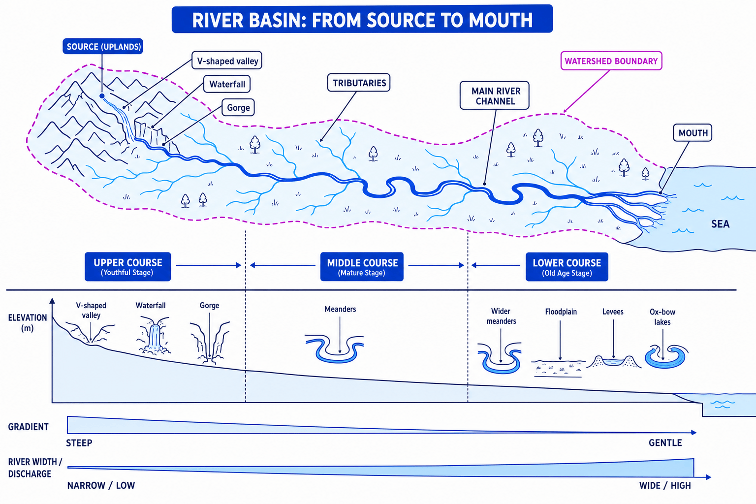
A river basin is the area of land drained by a river and its tributaries. Its edge is the watershed, the river begins at its source, and it ends at its mouth, often where it reaches the sea or a lake.
A tributary is a smaller river that joins a larger one. The point where they meet is called a confluence. As a river travels from source to mouth, its valley shape, channel size and landforms change.
The diagram below shows the typical pattern from the upper course to the lower course.
Long profile
A long profile is the side view of a river from its source to its mouth. It is usually steep near the source and becomes gentler downstream.
Downstream change
Near the source, rivers have steep gradients and mainly erode downwards. Further downstream, discharge increases, the channel becomes wider and deeper, and rivers increasingly erode sideways and deposit sediment.
2. The processes you need first
Before learning the landforms, you need the key processes.
Erosion means wearing away rock and sediment. In rivers, the main erosion processes are:
- Hydraulic action — the force of water hits the bed and banks, forcing air into cracks and weakening rock.
- Abrasion — stones carried by the river scrape and grind against the bed and banks.
- Attrition — sediment particles hit each other and become smaller, smoother and rounder.
- Solution — some minerals dissolve into the water.
Transportation means the river carrying its load, which is the sediment moved by the river.
Deposition means the river drops its load, usually when it loses energy. Fine river sediment deposited on land is called alluvium.
A river’s energy is strongly linked to gradient and discharge. Gradient is how steep the river is. Discharge is the amount of water flowing past a point in the river channel over time.
How processes vary from source to mouth
| Part of river | Typical conditions | Main processes | Common landforms |
|---|---|---|---|
| Upper course | Steep gradient, narrow channel, low discharge | Vertical erosion | V-shaped valleys, waterfalls, gorges |
| Middle course | Gentler gradient, wider channel, higher discharge | Lateral erosion and some deposition | Meanders |
| Lower course | Very gentle gradient, wide deep channel, high discharge | Deposition and lateral erosion | Floodplains, levees, ox-bow lakes |
Predicting landforms from river conditions
A fieldwork site has a steep gradient, shallow water, large angular stones and a narrow valley. What landforms would you expect nearby?
- The steep gradient means the river has enough energy to cut down into its bed, so vertical erosion is likely to dominate.
- Large angular stones suggest the river is close to its source, because the load has not yet been rounded much by attrition.
- These conditions match the upper course, so likely landforms include a V-shaped valley, and possibly a waterfall or gorge if resistant and softer rocks are present.
Mixing up erosion and weathering
Weathering breaks rock down where it is. Erosion removes and transports material away. In river landform answers, you usually need erosion processes such as hydraulic action and abrasion.
3. Upper-course landforms
The upper course is the section of river nearest the source. It is usually found in upland areas, such as the Pennines or Lake District in the UK.
V-shaped valleys
A V-shaped valley is a narrow valley with steep sides and a river at the bottom.
It forms because the river has a steep gradient and mainly erodes downwards through vertical erosion. The channel deepens, while weathering and small-scale mass movement loosen material on the valley sides. This material moves downslope into the river and is carried away, keeping the valley sides steep.
In the upper course, rivers are often not powerful enough to cut straight through ridges of harder rock. Instead, they wind around them, creating interlocking spurs — ridges of land that project into the valley from alternate sides.
A good UK example is upper Teesdale in northern England, where the River Tees flows through upland valleys before reaching High Force.
Waterfalls and gorges
Waterfall and gorge
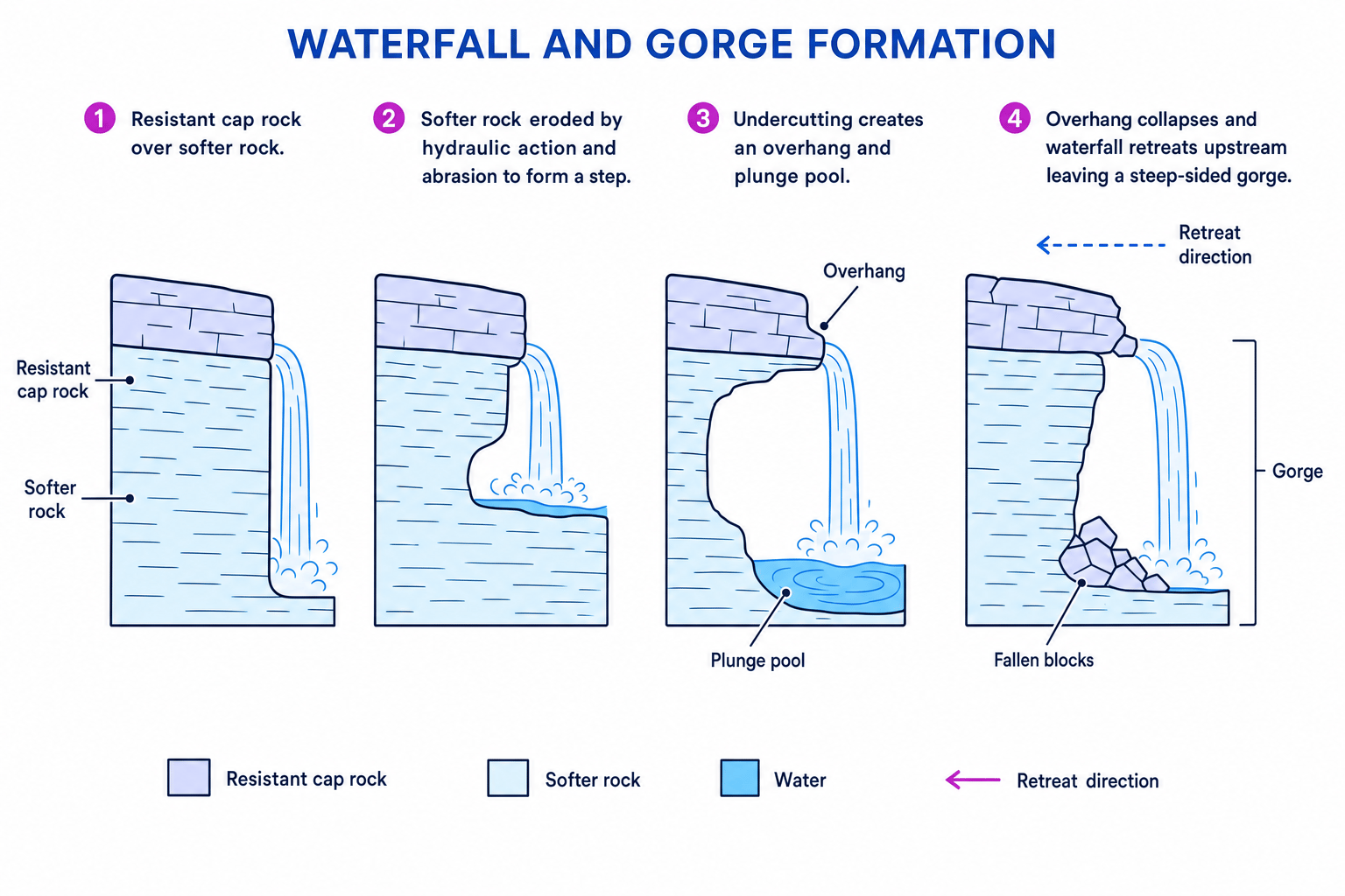
A waterfall is a sudden vertical or near-vertical drop in a river’s course. A gorge is a narrow, steep-sided valley, often formed as a waterfall retreats upstream.
Waterfalls often form where a river flows over resistant rock lying above softer rock. The softer rock erodes faster, creating a step.
High Force on the River Tees is a classic located example. The river flows over a hard Whin Sill dolerite layer, with softer rocks beneath. The waterfall is about 21 m high, though exact figures vary by source.
Explaining waterfall and gorge formation
- The river flows over resistant rock above softer rock, so the softer rock is eroded more quickly by hydraulic action and abrasion.
- Undercutting creates an overhang of resistant rock, while a plunge pool deepens at the base because falling water and swirling sediment increase erosion.
- The unsupported overhang eventually collapses, and the fallen blocks help erode the base by abrasion.
- This process repeats, so the waterfall retreats upstream and leaves behind a steep-sided gorge.
Use a process chain
For waterfall answers, try this order: resistant rock → softer rock erodes → overhang → collapse → retreat → gorge.
4. Middle-course landforms: meanders
The middle course has a gentler gradient and a larger discharge because tributaries have added more water. The river now has more energy overall, but less of it is used for cutting downwards. Instead, the river increasingly erodes sideways.
Meander
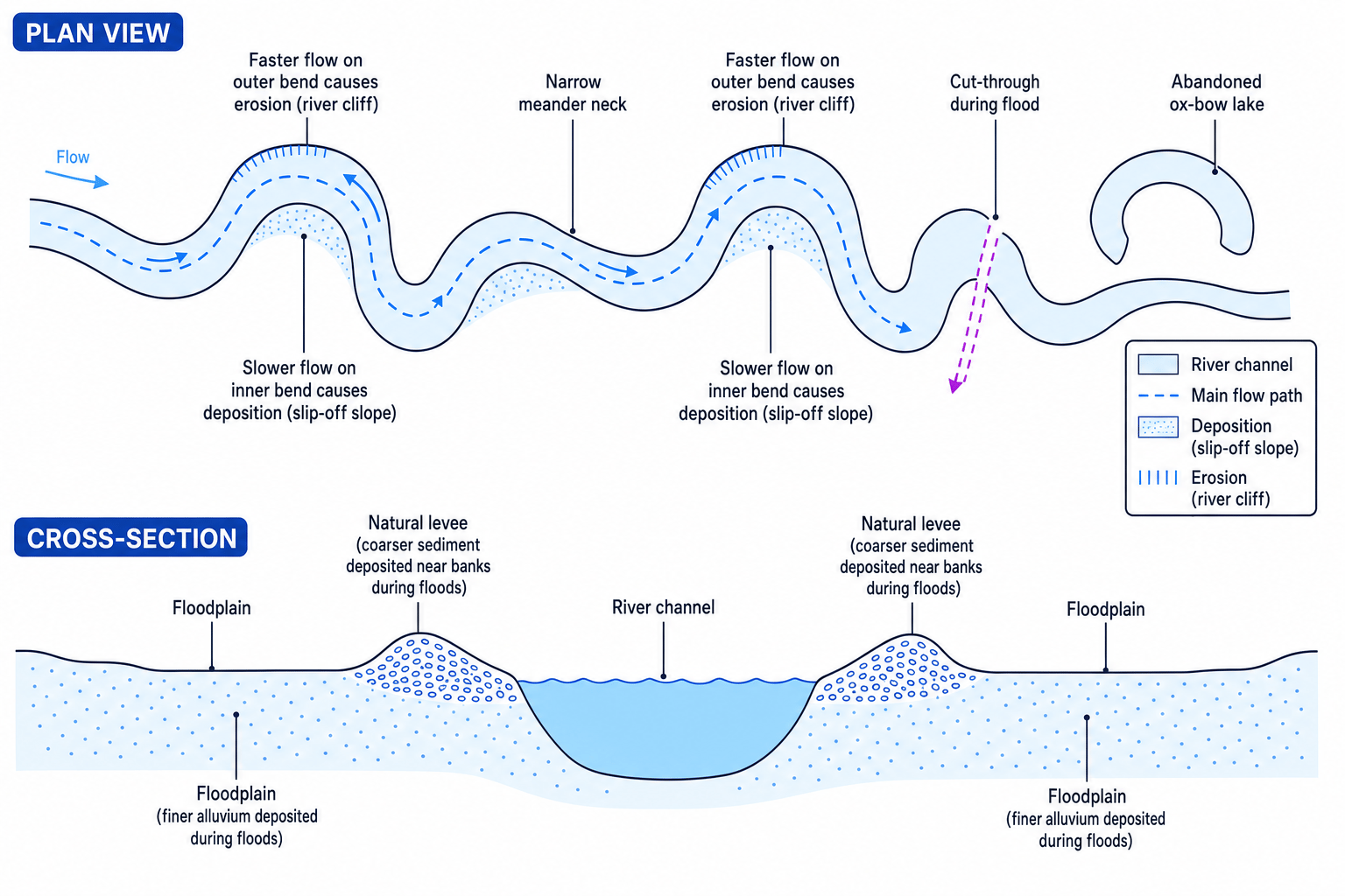
A meander is a bend in a river channel. Meanders form when erosion happens on the outside of bends and deposition happens on the inside of bends.
On the outside bend, water is deeper and flows faster. This causes erosion by hydraulic action and abrasion, forming a steep river cliff.
On the inside bend, water is shallower and slower. The river has less energy, so it deposits sediment, forming a gently sloping slip-off slope.
Over time, meanders migrate sideways and downstream. This widens the valley floor and helps prepare the landscape for floodplain formation later.
Using flow to explain a meander
- Compare the two sides of the bend: the outside bend has faster, deeper flow, while the inside bend has slower, shallower flow.
- Faster flow on the outside bend increases erosion, so a river cliff forms.
- Slower flow on the inside bend encourages deposition, so a slip-off slope forms.
- Continued erosion and deposition make the bend more pronounced, so the meander grows over time.
Saying meanders are only depositional
Meanders need both erosion and deposition. Erosion happens on the outside bend; deposition happens on the inside bend.
5. Lower-course landforms
The lower course is close to the mouth. The valley is wide and the gradient is very gentle. The river channel is usually wider and deeper, with high discharge and a large amount of fine sediment.
Ox-bow lakes
Ox-bow lake
An ox-bow lake is a crescent-shaped lake formed when a meander is cut off from the main river channel.
Ox-bow lakes form when erosion narrows the neck of a meander. During high discharge, such as a flood, the river may cut through the narrow neck and take the shorter, straighter route. Deposition then seals off the old bend, leaving a separate lake.
Over time, the ox-bow lake may dry up and become a curved marshy hollow.
Floodplains
Floodplain
A floodplain is the wide, flat area of land on either side of a river that is covered with water during floods.
Floodplains form through a combination of lateral erosion and deposition. As meanders move across the valley floor, they erode sideways and widen the valley. When the river floods, water spreads across the valley floor and loses energy. It deposits layers of alluvium, gradually building a flat, fertile floodplain.
Floodplains are common along lower-course rivers such as parts of the River Severn and lower River Tees.
Levees
Natural levee
A natural levee is a raised bank of sediment along the edge of a river channel, formed by repeated flooding.
When a river floods, water spills over the banks. As it leaves the channel, velocity drops suddenly. Coarser, heavier sediment is deposited closest to the channel, while finer sediment travels further across the floodplain. Repeated floods build up raised banks.
Explaining natural levees after a flood
- During a flood, the river exceeds bankfull capacity and water spills out of the channel onto the floodplain.
- As water leaves the deeper channel, it slows down, so it loses energy and deposits sediment.
- The heaviest sediment is dropped first beside the river, and repeated floods build raised natural banks called levees.
Confusing natural and artificial levees
A natural levee is built by deposited sediment during floods. An artificial levee is built by people as a flood defence. In formation questions, make it clear which one you mean.
6. How to link landforms to distance from the source
The key pattern is that landforms change because the balance between erosion, transportation and deposition changes downstream.
Near the source, steep gradients make vertical erosion important, forming V-shaped valleys, waterfalls and gorges.
In the middle course, the channel is wider and discharge is greater, so lateral erosion becomes more important, forming meanders.
Near the mouth, the river has a very gentle gradient and often carries lots of fine sediment. Deposition helps form floodplains, levees and ox-bow lakes.
The one-sentence summary
As a river moves downstream, landforms generally change from steep, erosion-dominated upper-course features to wider, flatter lower-course features shaped by lateral erosion and deposition.
7. Fieldwork link
This topic is ideal for local fieldwork. You might compare sites upstream and downstream by measuring channel width, depth, velocity, bedload size and valley shape.
For example, a local river investigation might show that upstream sites have larger, more angular sediment and a narrower channel, while downstream sites have a wider channel, smaller sediment and more evidence of deposition.
Good fieldwork language
When using fieldwork evidence, write about patterns downstream: “width increased”, “bedload became smaller and rounder”, or “the valley became wider and flatter”.
In the exam
- Link each landform to its river course: upper, middle or lower.
- Use process words accurately: vertical erosion, lateral erosion, hydraulic action, abrasion and deposition.
- Explain formation in a sequence using connectives like “because”, “therefore” and “over time”.
- Add a located example where useful, such as High Force on the River Tees for waterfalls and gorges.
- For diagrams or map extracts, describe what you can see first, then explain the process that caused it.
Check yourself
- Why are V-shaped valleys more common in the upper course than the lower course?
- How does a waterfall retreat to form a gorge?
- What is the difference between a floodplain, a levee and an ox-bow lake?
