

What you'll learn
- How erosion, transportation and deposition shape coastal landscapes.
- How headlands, bays, caves, arches and stacks form.
- How beaches and spits form through deposition and longshore drift.
- How to explain landform formation using clear process chains and named examples.
Start with the building blocks
A coastal landscape is the wider coastal area made up of linked landforms, processes and materials. A landform is a natural feature of the Earth’s surface, such as a beach, bay or stack.
At GCSE, the key skill is not just naming the landform. You need to explain how it formed by linking rock type, wave energy and coastal processes.
Coastal landform
A coastal landform is a natural feature at the coast created by processes such as erosion, transportation and deposition.
The main coastal processes
Erosion means the wearing away and removal of rock or sediment. At the coast, waves erode cliffs and headlands. Two especially useful processes are:
- Hydraulic action: waves force water and trapped air into cracks in rock, making the cracks widen.
- Abrasion: waves throw sand, pebbles and rock fragments against cliffs, scraping and wearing them away.
Weathering means rock breaking down in place, without being moved away immediately. For example, rainwater, salt and freeze-thaw action can weaken cliff rock.
Transportation means sediment being moved along the coast. Sediment is loose material such as sand, shingle, pebbles or mud.
Deposition happens when waves lose energy and drop sediment.
The process chain
Strong coastal explanations usually follow this chain: rock type or wave energy → process → change in shape → named landform.
Headlands and bays
A headland is a piece of land that sticks out into the sea. A bay is a curved indentation in the coastline, often with a beach inside it.
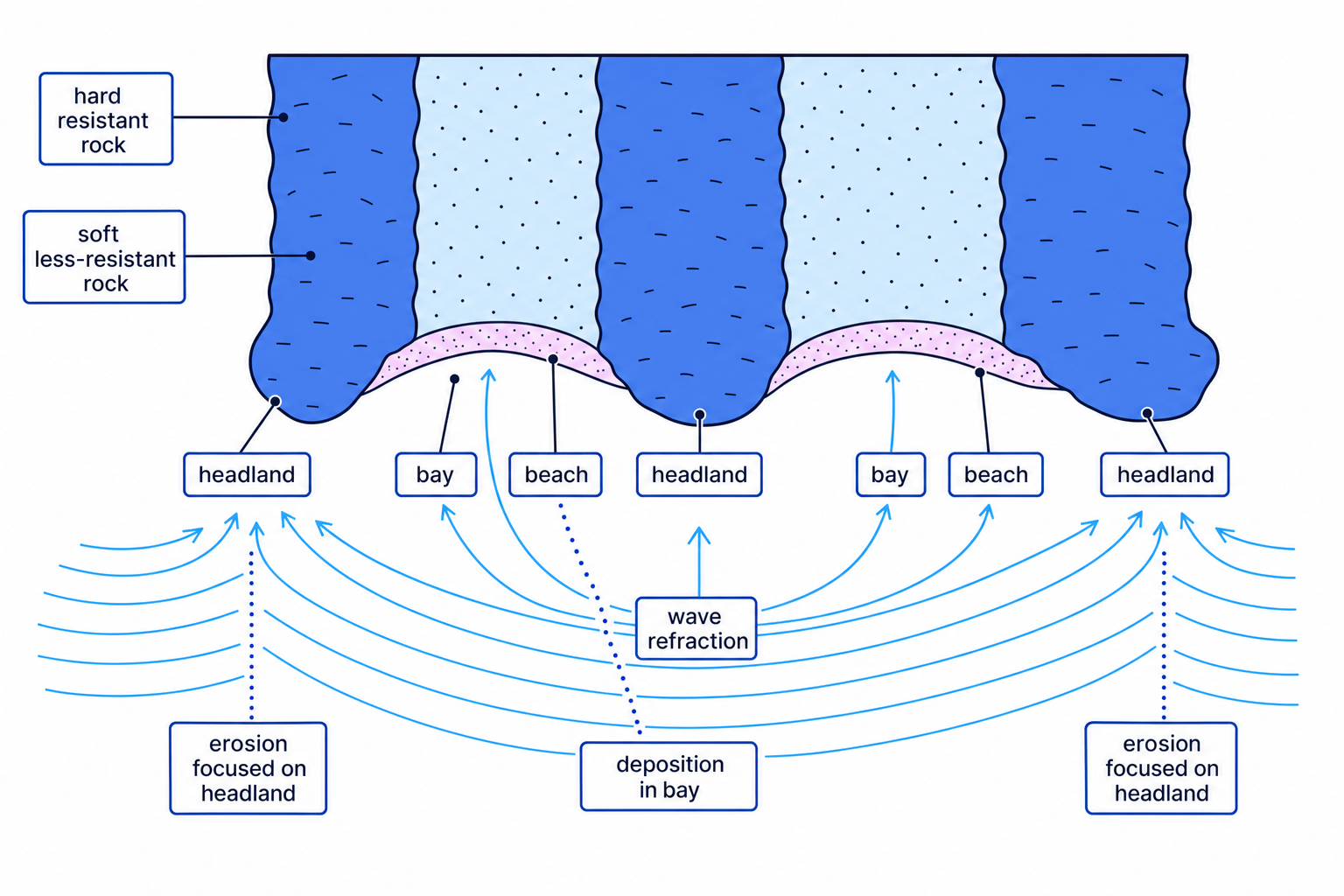
Headlands and bays usually form where bands of different rock meet the sea. Resistant rock is harder to erode. Less-resistant rock is easier to erode. When less-resistant rock erodes faster than resistant rock, this is called differential erosion.
Where less-resistant rock is eroded back, a bay forms. Where resistant rock remains sticking out, a headland forms.
A coastline with alternating bands of resistant and less-resistant rock at right angles to the sea is called a discordant coastline.
Why bays often contain beaches
Waves bend as they enter shallower water around a headland. This bending is called wave refraction. It concentrates wave energy on headlands, increasing erosion there.
Inside bays, wave energy is lower because the bay is more sheltered. This encourages deposition, so beaches often build up in bays.
A good UK example is Swanage Bay in Dorset, on the Jurassic Coast. Softer rocks have been eroded to form the bay, while more resistant rocks form headlands such as Ballard Point and Durlston Head.
Explaining headlands and bays from rock type
- Compare rock resistance: at Swanage, less-resistant rocks are eroded more easily than the more resistant rocks on either side.
- Apply differential erosion: hydraulic action and abrasion wear back the less-resistant rock more quickly, creating the curved bay.
- Link wave refraction to energy: waves bend around the headlands, so erosion is focused on the projecting resistant rock.
- Add deposition: the sheltered bay has lower wave energy, allowing sediment to be deposited as a beach.
Hard rock still erodes
Do not write that resistant rock “does not erode”. It erodes more slowly. Over time, headlands can still develop caves, arches and stacks.
Caves, arches and stacks
Headlands are exposed to powerful waves from several directions, so they often develop erosional landforms.
A crack is a line of weakness in rock. A joint is a natural crack in rock with little or no movement along it. Waves exploit these weaknesses.
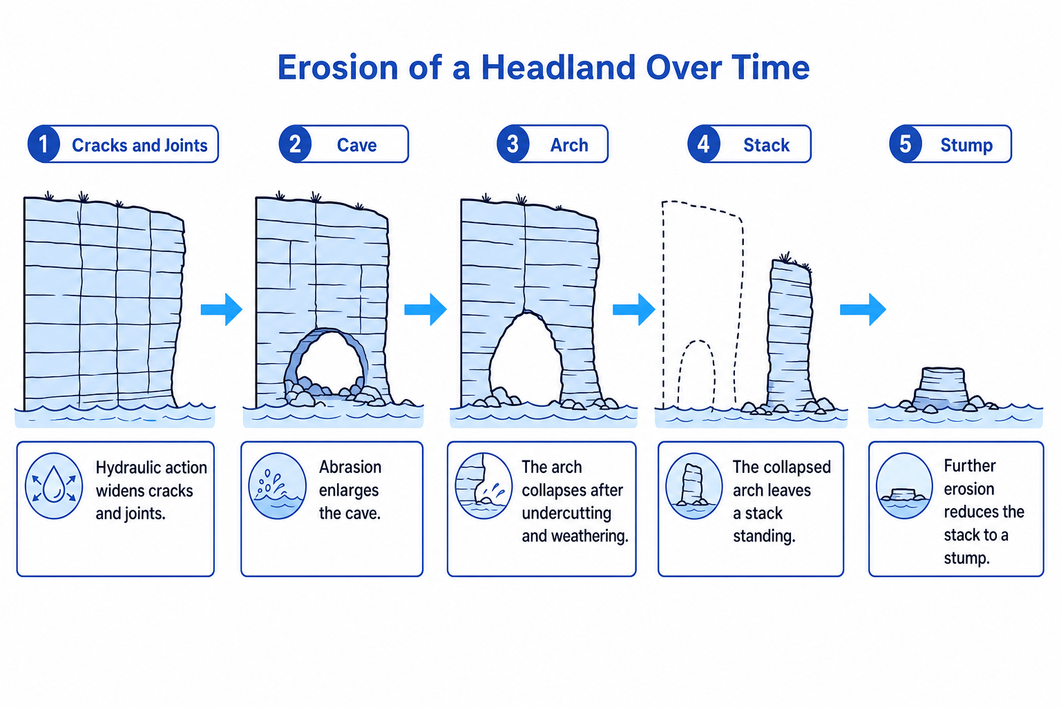
A cave is a hollow eroded into the base of a cliff or headland. An arch forms when erosion breaks through a headland, leaving a natural opening. A stack is an isolated pillar of rock left standing offshore after an arch collapses. A stump is the short remains of a stack after further erosion.
The formation sequence
The usual sequence is:
- Waves attack cracks and joints in a headland.
- Hydraulic action and abrasion widen the cracks into caves.
- Continued erosion deepens the cave until it breaks through the headland, forming an arch.
- Weathering weakens the arch roof, while erosion undercuts the base.
- The arch roof collapses under gravity, leaving a stack.
- Further erosion reduces the stack to a stump.
Named examples include Durdle Door, a famous arch in Dorset, and Old Harry Rocks, a group of chalk stacks near Studland in Dorset.
Sequencing cliff erosion on a headland
- Start with the weakness: waves attack joints in the headland because these are easier to widen than solid rock.
- Apply erosion: hydraulic action forces air and water into the joints, while abrasion scrapes the rock, forming a cave.
- Extend the landform: erosion continues through the headland until the cave becomes an arch.
- Explain the collapse: weathering weakens the arch roof and erosion undercuts the base, so gravity causes the roof to fall.
- Name the result: the remaining isolated pillar is a stack, which may later be eroded down into a stump.
Use sequence words
For cave–arch–stack formation, use words such as first, then, eventually and after further erosion. They help your explanation sound logical and geographical.
Beaches
A beach is an area of deposited sediment along the coast. Beaches may be made from sand, shingle or a mixture of both.
Beaches form where deposition is greater than erosion. This often happens in sheltered bays, where wave energy is lower. Sediment can come from cliff erosion, rivers, offshore deposits or longshore drift.
A constructive wave is a wave with a strong swash and weak backwash. Swash is the movement of water up the beach after a wave breaks. Backwash is the movement of water back down the beach due to gravity. Constructive waves build beaches because they push more sediment up the beach than they drag back.
A destructive wave has stronger backwash than swash, so it removes sediment and can make beaches narrower.
Beach features in the real world
At a local scale, beaches are not all the same. Sandy beaches are often flatter and wider, while shingle beaches are usually steeper because larger pebbles allow water to drain quickly, weakening backwash.
In fieldwork, you might investigate a beach by measuring a beach profile, which is a cross-section from the land towards the sea. You could also measure sediment size or roundness along a transect, which is a line used to collect data across a landscape.
Explaining beach deposition in a sheltered bay
- Judge the energy level: the bay is sheltered by headlands, so wave energy is lower than on an exposed headland.
- Apply the process: because waves have less energy, they cannot carry as much sediment, so deposition increases.
- Link waves to beach growth: constructive waves move sediment up the beach with strong swash and remove less with weak backwash.
- State the landform: over time, deposited sand or shingle builds up to form a beach.
Spits
A spit is a narrow ridge of sand or shingle joined to the land at one end, with the other end extending out into the sea or across an estuary.
An estuary is the tidal mouth of a river, where river water meets the sea. Spits often form where the coastline changes direction or at an estuary mouth.
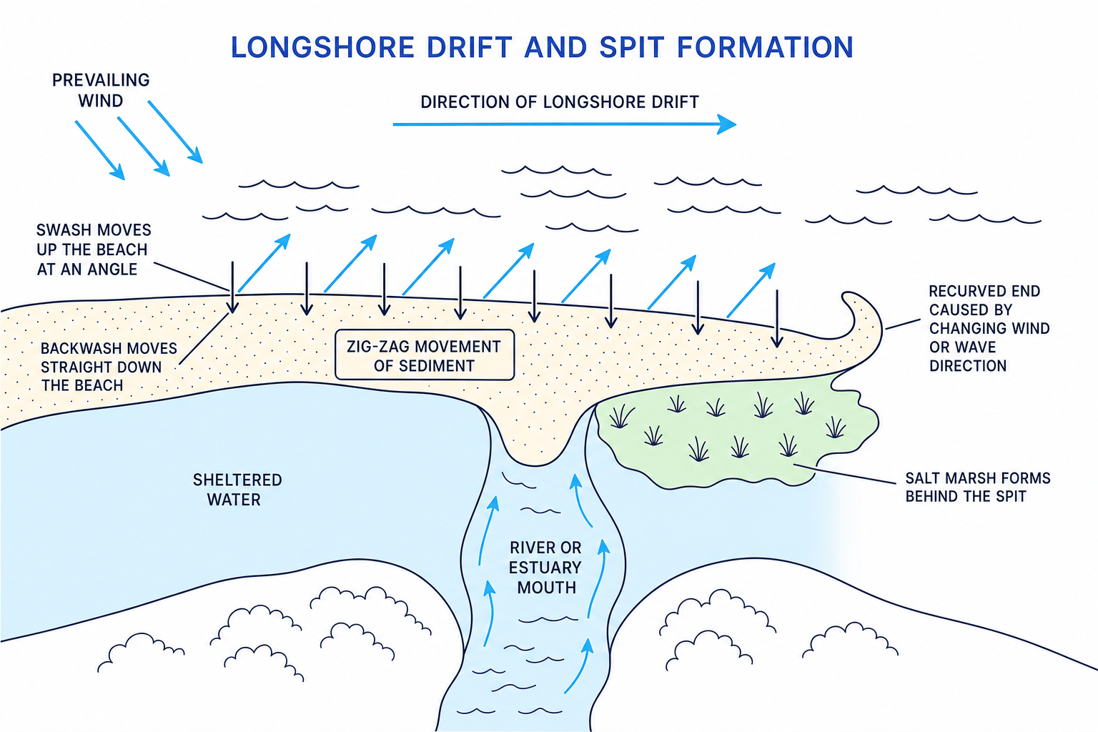
The key process is longshore drift, which is the zig-zag movement of sediment along the coast. It happens when the prevailing wind, the most common wind direction, makes waves approach the beach at an angle.
How longshore drift builds a spit
The swash moves sediment up the beach at an angle. The backwash then pulls it straight back down the beach under gravity. Repeated many times, this creates a zig-zag movement of sediment along the coast.
When the coastline suddenly changes direction, or when sediment reaches an estuary, longshore drift may continue moving sediment out into open water. Wave energy drops, so deposition forms a ridge: the spit.
The end of a spit may become recurved, meaning it bends back towards the land. This can happen when wind or wave direction changes.
Behind a spit, water is sheltered. Fine mud may be deposited, forming mudflats, which are flat areas of mud exposed at low tide. Over time, plants may colonise the mud and form a salt marsh, a coastal wetland that tolerates salty conditions.
A strong UK example is Spurn Head in East Yorkshire, where longshore drift moves sediment along the Holderness coast towards the Humber Estuary.
Predicting spit formation from wave direction
- Work out sediment movement: if waves approach the coast at an angle, swash moves sediment diagonally up the beach and backwash pulls it straight down.
- Apply longshore drift: repeated swash and backwash transport sediment along the coast in a zig-zag pattern.
- Identify the deposition point: when the coastline changes direction or reaches an estuary, wave energy falls and sediment is deposited outward from the land.
- Explain the final shape: a recurved end may form if wind or wave direction changes, while sheltered water behind the spit encourages mudflats and salt marsh.
Spit or bar?
A spit is attached to the land at one end only. A bar is a depositional ridge that joins two areas of land across a bay or river mouth.
Bringing the landforms together
Coastal landscapes are usually a mix of erosional and depositional features. For example, a regional coastline such as Dorset may include bays, beaches, arches and stacks. A local place such as Spurn Head may be dominated by deposition and longshore drift.
The best answers connect the landform to the process. Do not just say “erosion forms a cave”. Be precise: hydraulic action widens cracks, abrasion enlarges the hollow, and continued erosion forms a cave.
In the exam
- Use a clear sequence: process → effect → landform. For example, “hydraulic action widens joints, forming a cave.”
- Include accurate terms such as differential erosion, wave refraction, constructive waves and longshore drift where relevant.
- Use a named example if you can, such as Swanage Bay, Durdle Door, Old Harry Rocks or Spurn Head.
- For formation questions, avoid vague phrases like “the sea makes it”. Name the exact process and explain how the shape changes.
Check yourself
- How does differential erosion create a headland and bay coastline?
- What is the full sequence from crack to cave to arch to stack?
- Why does longshore drift help create a spit at an estuary mouth?
