

What you'll learn
- How geology (rock type and structure), climate (average weather conditions) and human activity shape UK landscapes.
- How to use one UK river basin and one UK coastal landscape as detailed case studies.
- How to explain landforms, processes and management using named place evidence.
- How to avoid “listing” factors and instead show how they work together.
The big idea: landscapes are systems
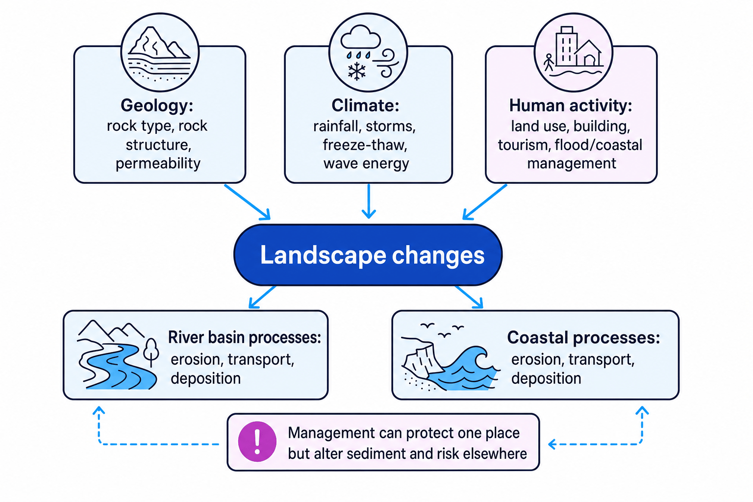
A landscape is not fixed. Rivers shift their channels, cliffs retreat, beaches grow or shrink, and people try to manage risk. In OCR GCSE Geography, you need to show that landscapes change because several factors interact.
These notes use two common UK case studies: the River Tees basin in North East England and the Holderness Coast in East Yorkshire. If your class uses different case studies, keep the same structure but swap in your own named evidence.
Core terms
- A landscape is a visible part of the Earth’s surface, including physical features such as rivers, cliffs and valleys, and human features such as settlements, roads and flood defences.
- Dynamic means changing over time.
- Geology means the rock type, rock structure and rock properties beneath a landscape.
- Climate means the average weather conditions of a place, including rainfall, temperature and storminess.
- Human activity means the ways people use, change and manage the landscape.
The diagram below shows the basic relationship: geology, climate and people all affect the land-shaping processes operating in river and coastal landscapes.
Process vocabulary you must be secure with
Geomorphic processes
Geomorphic processes are natural processes that shape the Earth’s surface. The key ones are weathering (rock breaks down in place), mass movement (material moves downslope under gravity), erosion (rock or sediment is worn away), transportation (material is moved) and deposition (material is dropped).
In both rivers and coasts, the same broad process pattern appears:
- Material is weathered and loosened.
- It is eroded by water, waves or gravity.
- It is transported as sediment.
- It is deposited when energy falls.
The difference is the energy source. In a river, flowing water provides energy. At the coast, waves, tides and currents provide energy.
Linking a storm to river-basin change
- Heavy rainfall saturates the soil, so infiltration — water soaking into the ground — decreases and surface runoff — water flowing over the land — increases.
- More runoff raises river discharge, which is the volume of water flowing past a point each second, so the river has more energy.
- With more energy, the river can erode its bed and banks by hydraulic action and abrasion, transport larger sediment, and later deposit material when floodwater slows on a floodplain.
Listing factors separately
Do not write three disconnected paragraphs on geology, climate and people. Strong answers show links, for example: “soft rock plus storm waves plus groynes interrupting sediment movement causes uneven erosion along the coast.”
Thinking at different scales
Scale
Scale means the size level you are thinking about: a whole region, one river basin, one coastline, one town, or one landform.
You need to move between scales:
- At a regional scale, geology and climate influence a whole river basin or coastal stretch.
- At a local scale, individual features such as a waterfall, meander, cliff, groyne or beach show detailed process impacts.
- Over short timescales, storms can cause sudden floods or cliff falls.
- Over longer timescales, rivers migrate across floodplains and coasts retreat or build out through deposition.
Use a chain of explanation
A strong case-study sentence often follows this pattern: driver → process → landform or impact → named place detail.
Example: “At Holderness, soft glacial till is easily saturated, so mass movement and wave erosion cause rapid cliff retreat, especially on undefended sections south of Mappleton.”
Case study 1: River Tees basin
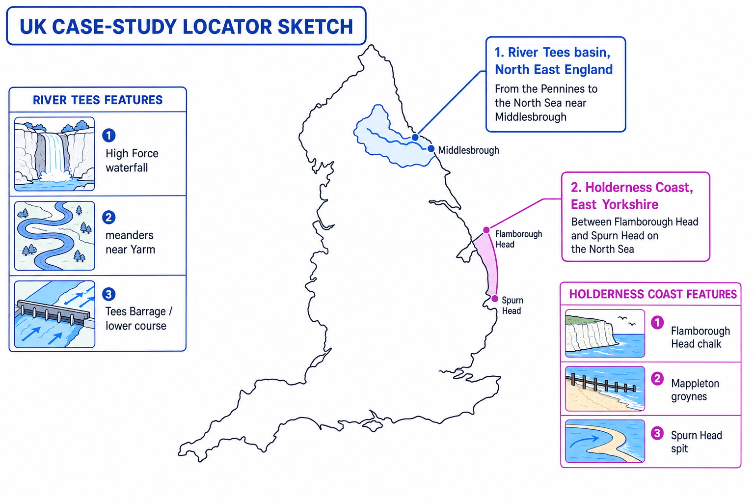
A river basin, also called a drainage basin, is the area of land drained by a river and its tributaries. The River Tees is about 137 km long, flowing from the Pennines near Cross Fell to the North Sea near Middlesbrough.
The map below locates the River Tees basin and the Holderness Coast, with key features you can use as named evidence.
How geology influences the River Tees
In the upper course, the Tees flows over resistant rocks in the Pennines, including the hard Whin Sill at High Force. Where hard rock lies above softer rocks, the softer rock erodes faster, helping to form a waterfall and gorge.
In the lower course, the valley is gentler and wider, with more deposition and floodplain development. The river has less gradient, so lateral erosion and deposition become more important than vertical erosion.
How climate influences the River Tees
The Pennine uplands are cooler and wetter than the lowlands. Heavy rainfall increases runoff, discharge and erosion. Freeze-thaw weathering can also break up exposed upland rock, adding angular material to slopes and channels.
During very wet periods, the river transports more sediment and flood risk increases downstream, especially where the valley is flatter and more built-up.
Landforms and features in the River Tees case study
Key landforms and features include:
- V-shaped valleys and interlocking spurs in the upper course, formed by vertical erosion.
- High Force waterfall, where resistant Whin Sill overlies softer rocks.
- A gorge downstream of High Force, created as the waterfall retreats upstream.
- Meanders near places such as Yarm, where lateral erosion forms river cliffs and deposition forms slip-off slopes.
- Floodplains and urban river management in the lower course around Stockton and Middlesbrough.
Explaining High Force waterfall formation
- The river crosses a band of hard Whin Sill rock lying above softer sedimentary rocks, so the softer rock is less resistant to erosion.
- Hydraulic action and abrasion erode the softer rock more quickly, creating an undercut section beneath the hard cap rock.
- The unsupported hard rock eventually collapses into the plunge pool, where the fallen blocks help further abrasion.
- Repeated collapse causes the waterfall to retreat upstream, leaving a steep-sided gorge behind.
Human activity and management in the River Tees basin
People influence the Tees in several ways. In the upper basin, Cow Green Reservoir stores and regulates water. This can reduce some peak flows downstream and provide water supply, but it may also alter natural flow and sediment movement.
In the lower basin, urban areas such as Stockton and Middlesbrough have more impermeable surfaces — surfaces water cannot easily soak through — so runoff can increase. The Tees Barrage, opened in 1995, controls tidal movement and helps maintain water levels for recreation and redevelopment. However, river management can also affect sediment movement, habitats and fish passage.
River landscapes are linked systems
A river landform is rarely caused by one factor. In the Tees, geology creates contrasts in resistance, climate controls flow energy, and human management changes discharge, sediment and flood risk.
Case study 2: Holderness Coast
A coastal landscape is the zone where land, sea and atmosphere interact. The Holderness Coast runs along East Yorkshire between Flamborough Head and Spurn Head. It is one of the fastest eroding coastlines in Europe, often quoted at around 1–2 m per year on average, though rates vary by location and year.
How geology influences Holderness
Holderness is mainly made of soft glacial till, also called boulder clay. This is a weak, unconsolidated mixture of clay, sand and stones left by ice sheets. It erodes much more easily than solid rock.
At Flamborough Head, the geology is more resistant chalk. This creates high cliffs and headland features, while the softer Holderness cliffs retreat more rapidly to the south.
How climate and marine conditions influence Holderness
Storms in the North Sea create high-energy destructive waves, especially when winds blow from the north-east across a long fetch, which is the distance of open water over which wind can build waves. Heavy rain also saturates the boulder clay, making it heavier and more likely to slump.
Coastal processes
At the coast, marine processes are caused by the sea, such as wave erosion and longshore drift. Sub-aerial processes are land-based processes, such as weathering and mass movement, that happen above sea level but still weaken cliffs.
Landforms and features in the Holderness case study
Important features include:
- Chalk cliffs at Flamborough Head, with caves, arches and stacks in places.
- Soft boulder clay cliffs along much of Holderness, affected by slumping and cliff retreat.
- Narrow beaches where sediment is quickly moved away.
- Spurn Head, a spit formed by deposition where sediment transported southwards by longshore drift is deposited.
Longshore drift
Longshore drift is the zig-zag movement of sediment along a coastline. Waves usually approach the beach at an angle, move sediment up the beach in the swash, and gravity pulls it back down in the backwash.
Human activity and management at Holderness
Human activity strongly affects the Holderness Coast because management changes the sediment budget, which is the balance between sediment being added, moved and removed from a stretch of coast.
At Mappleton, rock armour and groynes were built in 1991 to protect the village and the B1242 road. The groynes trap sediment moving south by longshore drift. This creates a wider beach at Mappleton, which absorbs wave energy and reduces erosion locally.
However, trapping sediment means less material reaches the coast further south. Beaches there may become narrower, so waves attack the cliffs more directly. This can increase erosion on undefended farmland and settlements down-drift.
Evaluating Mappleton groynes
- Identify the natural process: longshore drift moves sediment mainly from north to south along Holderness.
- Apply the management effect: groynes at Mappleton trap this sediment, building a wider protective beach in front of the village.
- Trace the knock-on impact: areas south of Mappleton receive less sediment, so beaches can narrow and cliff erosion may increase.
- Make a balanced judgement: the scheme is effective locally, but it transfers some erosion risk along the coast rather than removing it from the whole system.
Saying defences stop erosion
Coastal defences usually reduce erosion in a particular place. They do not stop coastal processes across the whole sediment cell, and they can create new problems elsewhere.
How to compare the two case studies
The River Tees and Holderness Coast are different landscapes, but the exam logic is similar.
Similarities
Both are shaped by:
- geology, especially rock resistance and permeability;
- climate, especially rainfall, storms and high-energy events;
- erosion, transportation and deposition;
- human management that changes natural flows of water or sediment.
Differences
The main energy source differs. In the River Tees, energy comes from river discharge and gradient. At Holderness, energy comes mainly from waves, tides, currents and storms.
The main management issue also differs. In the Tees, management often focuses on water levels, flood risk, supply and urban redevelopment. At Holderness, management focuses on coastal erosion, property protection and sediment movement.
Fieldwork links
This topic has strong fieldwork opportunities. In a river basin, you might measure channel width, depth, velocity and bedload size along a downstream transect, which is a line or route along which data is collected.
At the coast, you might measure beach profiles, sediment size and roundness, or compare managed and unmanaged stretches of coast. Photographs, field sketches and land-use mapping help you link physical processes with human decisions.
In the exam
- Use named evidence: include places such as High Force, Yarm, Middlesbrough, Mappleton, Flamborough Head and Spurn Head where relevant.
- Explain interactions: link geology, climate and human activity rather than treating them as separate lists.
- For management questions, always consider both the protected location and the knock-on effects elsewhere in the river basin or coastal system.
Check yourself
- How does geology help explain the formation of High Force on the River Tees?
- Why does Holderness erode rapidly, and why are erosion rates uneven along the coast?
- How can management protect one place while increasing risk somewhere else?
