

What you'll learn
- How tropical cyclones form from global atmospheric circulation and warm ocean conditions.
- Where tropical cyclones happen, how often they occur, and how this may be changing.
- Why tropical cyclones become natural hazards: wind, rain, storm surges, floods and landslides.
- How impacts and responses differ between a developed country and an emerging/developing country.
What is a tropical cyclone?
Tropical cyclone
A tropical cyclone is a powerful, rotating, low-pressure storm that forms over warm tropical oceans. It has very strong winds, heavy rain and organised bands of cloud around a central eye.
Different parts of the world use different names:
- Hurricanes: North Atlantic and northeast Pacific.
- Typhoons: northwest Pacific, especially East and Southeast Asia.
- Cyclones: Indian Ocean and South Pacific.
A storm is usually classed as a tropical cyclone once sustained winds reach at least 119 km/h. The strongest storms can be hundreds of kilometres wide and last for several days or even weeks if they stay over warm ocean water.
Weather hazard
A weather hazard is an atmospheric event that threatens people, property, infrastructure or the environment. A tropical cyclone is only a hazard when it has the potential to affect people or places.
How global circulation helps create tropical cyclones
To understand cyclone formation, start with the global atmospheric circulation: the worldwide pattern of air movement caused by uneven heating of Earth’s surface.
The tropics receive intense solar energy. Warm air rises near the Equator, creating low pressure and heavy convectional rainfall. This rising air is part of the Hadley cell, a large circulation cell between the Equator and about 30° north and south.
Coriolis effect
The Coriolis effect is the apparent deflection of moving air caused by Earth’s rotation. It helps storms spin anticlockwise in the Northern Hemisphere and clockwise in the Southern Hemisphere.
Tropical cyclones usually form between about 5° and 30° north or south of the Equator. They do not usually form exactly on the Equator because the Coriolis effect is too weak there to create strong rotation.
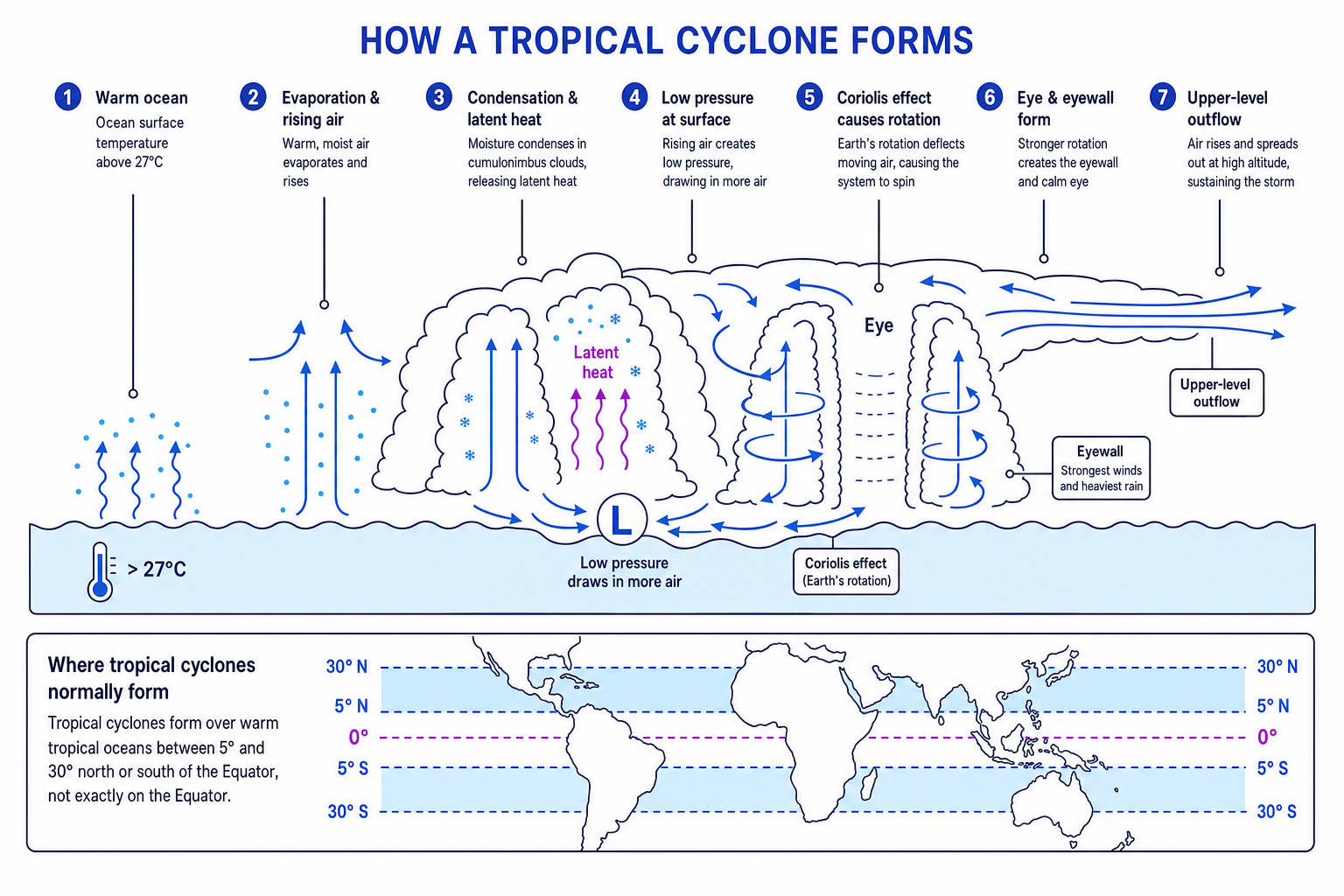
The formation sequence
A tropical cyclone needs several conditions:
- Sea surface temperatures of about 27°C or more.
- Deep warm water, so the storm is not quickly “starved” of heat.
- Moist, unstable air that can rise rapidly.
- Low vertical wind shear, meaning winds do not change too much with height.
- Enough Coriolis effect to make the system rotate.
- A small existing disturbance, such as a cluster of thunderstorms.
The sequence is:
- Warm ocean water causes rapid evaporation, adding moisture to the air.
- Warm, moist air rises, creating low pressure at the surface.
- More air is drawn in towards the low-pressure centre.
- Rising air cools and condenses into tall cumulonimbus clouds, releasing latent heat.
- Latent heat provides extra energy, making air rise faster and pressure fall further.
- The Coriolis effect makes the inflowing air rotate.
- A calm eye may form at the centre, surrounded by the violent eyewall, where the strongest winds and heaviest rain occur.
The energy source
A tropical cyclone is powered by heat and moisture from warm ocean water. When it moves over land or cooler water, it loses its main energy supply and usually weakens.
Deciding if a tropical cyclone could form
A weather disturbance is recorded at 2°N over ocean water at 29°C with low wind shear. Could it become a tropical cyclone?
- Check the sea temperature: 29°C is warm enough, so the ocean can provide heat and moisture.
- Check wind shear: low wind shear helps the storm stay vertically organised, so this condition is also favourable.
- Check latitude: 2°N is too close to the Equator, where the Coriolis effect is weak, so strong rotation is unlikely.
- Overall, the disturbance has warm water and low wind shear, but it is probably too close to the Equator to develop into a full tropical cyclone.
Equator misunderstanding
Do not write that tropical cyclones form “at the Equator”. They form in the tropics, but usually at least about 5° away from the Equator because they need the Coriolis effect to spin.
Distribution and frequency
Tropical cyclones occur over warm tropical oceans, especially in these main basins:
- North Atlantic, including the Caribbean and Gulf of Mexico.
- Northeast Pacific, off the west coast of Mexico and Central America.
- Northwest Pacific, affecting countries such as the Philippines, Japan and China.
- North Indian Ocean, including the Bay of Bengal.
- Southwest Indian Ocean, affecting places such as Madagascar and Mozambique.
- Around northern Australia and the South Pacific.
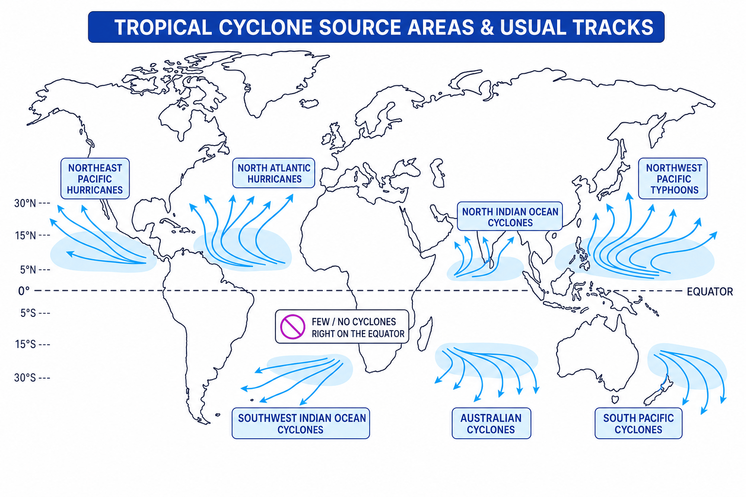
Globally, there are usually around 80 to 90 tropical storms each year, though not all become the strongest category of cyclone. Frequency varies by ocean basin and by year.
Tropical cyclones are seasonal:
- North Atlantic hurricane season: usually June to November.
- Northwest Pacific typhoons: can occur through much of the year, but often peak from summer to autumn.
- Southern Hemisphere cyclones: usually November to April.
How patterns may change over time
Climate change does not simply mean “more cyclones everywhere”. The evidence is more careful than that.
Warmer oceans can increase the chance of:
- Stronger storms, with a higher proportion reaching very intense categories.
- Heavier rainfall, because warmer air can hold more moisture.
- Higher storm-surge risk, because sea levels are rising.
- Rapid intensification, where a storm strengthens quickly before landfall.
However, the total number of tropical cyclones globally may not increase clearly, and some projections suggest there could be fewer storms overall but a larger share of very intense ones. Trends also vary between ocean basins.
A balanced climate-change sentence
A strong GCSE answer says: “Climate change is likely to increase cyclone intensity and rainfall, but changes in overall frequency are less certain and vary by region.”
Why tropical cyclones are natural hazards
Tropical cyclones are hazardous because they combine several dangerous processes at once.
Storm surge
A storm surge is a temporary rise in sea level caused by very low air pressure and strong winds pushing seawater towards the coast.
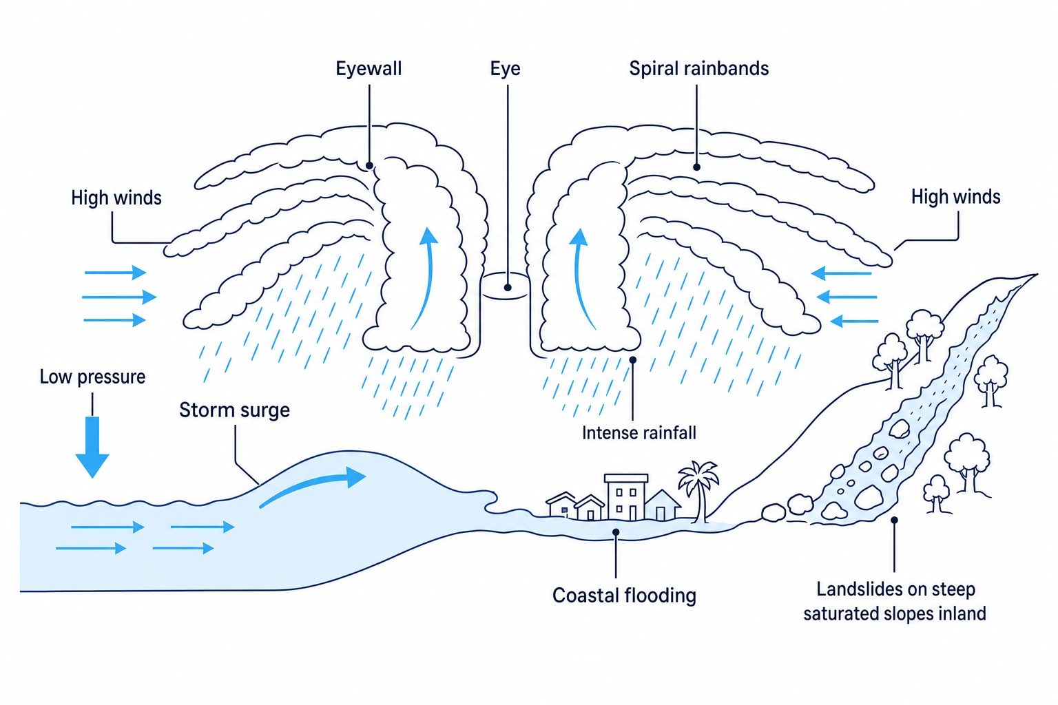
Main hazards
- High winds can destroy roofs, power lines, trees, vehicles and weak buildings.
- Intense rainfall can cause flash flooding and river flooding.
- Storm surges can flood low-lying coastal areas, especially if they arrive at high tide.
- Coastal flooding can damage homes, roads, ports, farmland and freshwater supplies.
- Landslides can occur where heavy rain saturates steep slopes, especially in deforested or mountainous areas.
Linking hazards to likely impacts
A tropical cyclone is forecast to hit a low-lying coastal city with steep hills inland. Which hazards are likely to be most serious?
- The low-lying coast increases exposure to storm surge and coastal flooding, because seawater can be pushed inland across flat land.
- The steep hills inland increase landslide risk, because intense rainfall can saturate slopes and make them unstable.
- The city setting increases social and economic impacts, because dense population, roads, power supplies and businesses are concentrated in the hazard zone.
Impacts depend on level of development
A country’s level of development affects both vulnerability and capacity to respond.
Richer countries often have stronger buildings, better forecasting, more emergency services and insurance systems. However, they may still suffer very high economic losses because infrastructure and property values are high.
Emerging and developing countries may have fewer resources for protection, evacuation, healthcare and rebuilding. Informal housing, poverty, weak infrastructure and limited insurance can make impacts more severe and recovery slower.
Deaths versus costs
Do not assume the “worst” cyclone is always the one with the highest financial cost. Developed countries often record huge economic losses, while poorer countries may suffer higher death tolls and longer-term social impacts.
Located example in a developed country: Hurricane Katrina, USA
Hurricane Katrina struck the USA in August 2005. The USA is a developed country with high income, advanced forecasting and major emergency services. The worst impacts were in New Orleans, Louisiana, a low-lying city on the Gulf Coast.
Katrina reached Category 5 over the Gulf of Mexico, then made landfall as a weaker but still extremely dangerous storm. The storm surge contributed to failures in New Orleans’ levee system.
Impacts
- Social: over 1,800 people died across affected areas, and many residents were displaced from New Orleans.
- Economic: damage was over US$100 billion, including homes, roads, oil facilities, businesses and flood defences.
- Environmental: floodwater was polluted by sewage, chemicals and oil; coastal wetlands were damaged.
Responses
- Individuals: many people evacuated before landfall, though some could not leave because of age, poverty, illness or lack of transport.
- Organisations: charities such as the American Red Cross provided shelters, food and medical support.
- Government: local, state and federal authorities organised evacuation orders, emergency shelters and later rebuilding. FEMA, the federal emergency agency, was criticised for a slow and poorly coordinated response in the first days after the disaster.
Located example in an emerging/developing country: Typhoon Haiyan, Philippines
Typhoon Haiyan struck the Philippines in November 2013. The Philippines is an emerging/developing country in Southeast Asia made up of many islands, with many coastal communities exposed to tropical cyclones. One of the worst-hit places was Tacloban City on Leyte Island.
Haiyan was one of the strongest tropical cyclones recorded at landfall, with extremely high winds and a devastating storm surge.
Impacts
- Social: over 6,000 people died, and millions were affected or displaced.
- Economic: homes, fishing boats, crops, roads and airports were damaged; total losses were several billion US dollars, depending on the source used.
- Environmental: saltwater flooded farmland, trees were flattened, and debris polluted coastal areas.
Responses
- Individuals: people moved to evacuation centres, although some shelters were damaged or overwhelmed.
- Organisations: the UN, Red Cross, NGOs and international governments sent emergency food, water, medical supplies and temporary shelter.
- Government: the Philippine government issued warnings, organised evacuations and later introduced “Build Back Better” recovery plans, including stronger shelters and no-build zones in some exposed coastal areas.
Comparing the two examples
Katrina and Haiyan show that tropical cyclones can be devastating in countries at very different development levels. The USA had more financial resources, but New Orleans was highly exposed because of its low-lying location and levee failures. The Philippines faced greater challenges with evacuation, emergency shelter, healthcare access and rebuilding across many islands.
Development affects risk
The hazard may be natural, but the disaster impact depends heavily on human factors: wealth, planning, building quality, warning systems, evacuation, healthcare and government organisation.
In the exam
- For formation questions, link warm ocean water, rising moist air, low pressure, latent heat and Coriolis rotation in a clear sequence.
- For distribution questions, use place language: name ocean basins and mention 5° to 30° north and south of the Equator.
- For impacts and responses, separate social, economic and environmental impacts, then compare individuals, organisations and governments.
- For case studies, include located detail such as New Orleans, Louisiana, USA, and Tacloban, Leyte, Philippines.
- For climate-change questions, be balanced: intensity and rainfall are likely to increase, but total frequency is less certain.
Check yourself
- Why do tropical cyclones need warm ocean water and the Coriolis effect?
- How are storm surges different from heavy rainfall flooding?
- How did the impacts and responses differ between Hurricane Katrina and Typhoon Haiyan?
