

What you'll learn
- How the atmosphere and oceans move heat around the planet.
- Why climate has changed naturally during the Quaternary period.
- How human activity strengthens the greenhouse effect.
- Why the UK has a distinctive climate, and why it varies from west to east and north to south.
1. The atmosphere as a global system
The atmosphere is the layer of gases surrounding Earth. It matters in geography because it moves heat energy and moisture around the planet, creating pressure belts, winds, rainfall patterns and climate zones.
Weather and climate
Weather means day-to-day atmospheric conditions, such as temperature, rainfall, wind and cloud. Climate means the average weather conditions of a place, usually measured over 30 years or more.
Earth is heated unevenly by the Sun. Near the Equator, incoming solar energy is concentrated over a smaller surface area, so it is hotter. Near the poles, the Sun’s rays are spread over a larger area and pass through more atmosphere, so it is colder.
This temperature difference creates convection, which is the movement of air caused by heating and cooling. Warm air expands, becomes less dense and rises. Cool air is denser and sinks.
The big driver
Global atmospheric circulation begins because the Equator receives more heat than the poles. The atmosphere then transfers some of this energy away from the Equator.
2. Global atmospheric circulation
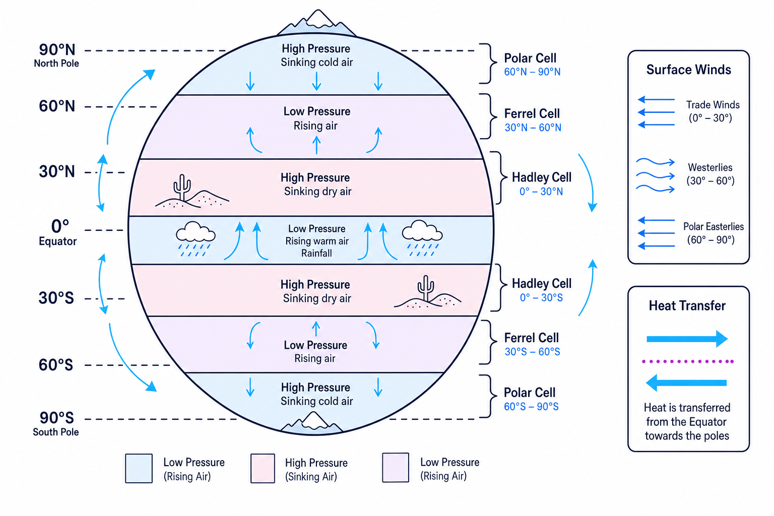
Global atmospheric circulation is the worldwide pattern of large-scale air movement. It is organised into three main circulation cells in each hemisphere: the Hadley cell, Ferrel cell and Polar cell.
Pressure belts
Air pressure is the weight of air pressing down on Earth’s surface.
- Low pressure forms where air rises. Rising air cools, water vapour condenses, and clouds and rainfall often form.
- High pressure forms where air sinks. Sinking air warms, becomes drier, and cloud formation is less likely.
At the Equator, warm moist air rises, creating low pressure and heavy rainfall. Around 30° north and south, air sinks, creating high pressure and dry conditions. This helps explain why many hot deserts, such as the Sahara in North Africa, are found near 30° latitude.
Wind belts
Wind is air moving from high pressure to low pressure. Earth’s rotation causes the Coriolis effect, which deflects winds: to the right in the Northern Hemisphere and to the left in the Southern Hemisphere.
The main surface winds are:
- Trade winds: blow towards the Equator from around 30°.
- Westerlies: blow from west to east between around 30° and 60°.
- Polar easterlies: blow from the poles towards around 60°.
Explaining desert belts near 30°
- Intense heating at the Equator makes warm, moist air rise, producing low pressure and frequent rainfall.
- Higher in the atmosphere, this air moves away from the Equator towards about 30° north and south.
- By around 30°, the air sinks, warms and becomes drier, so clouds are less likely to form and rainfall is low.
High pressure does not mean heavy rain
Students sometimes link “high” with “more rainfall”. In climate, high pressure usually means sinking air, clearer skies and drier conditions.
3. How oceans redistribute heat
The atmosphere is not working alone. Ocean currents are large-scale movements of seawater. They transfer heat around the world too.
Warm currents move heat from lower latitudes towards higher latitudes. Cold currents move cooler water back towards the tropics. This helps reduce the temperature difference between the Equator and the poles.
A key example for the UK is the North Atlantic Drift, a warm ocean current that brings relatively warm water across the Atlantic towards north-west Europe. This helps keep the UK milder than many places at similar latitudes, such as parts of Canada.
Atmosphere plus oceans
Heat is redistributed by both moving air and moving water. This is why global climate patterns are linked across oceans and continents.
4. Natural climate change in the past
Climate has never been completely fixed. The Quaternary period is the most recent geological period, beginning about 2.6 million years ago and continuing to today.
During the Quaternary, Earth has moved between:
- Glacial periods: colder phases when ice sheets expanded.
- Interglacial periods: warmer phases when ice retreated.
We are currently in an interglacial period called the Holocene.
Natural causes of climate change
Milankovitch cycles are slow changes in Earth’s orbit and tilt. They affect how much solar energy different parts of Earth receive, especially at high latitudes. They operate over thousands to hundreds of thousands of years.
They include:
- Changes in the shape of Earth’s orbit.
- Changes in the angle of Earth’s tilt.
- Wobble in Earth’s axis.
Solar variation means changes in the amount of energy released by the Sun. These are usually smaller and shorter-term than Milankovitch cycles.
Volcanism means volcanic activity. Major eruptions can send ash and sulphate particles into the atmosphere. These reflect some sunlight back into space, causing short-term cooling for months or years.
Evidence for past climate change
Geographers and scientists use several types of evidence:
- Ice cores: cylinders of ice drilled from ice sheets. They contain trapped air bubbles and chemical clues about past temperature and greenhouse gases.
- Pollen records: preserved pollen shows which plants grew in the past, helping us infer whether conditions were warmer, colder, wetter or drier.
- Tree rings: wider rings often suggest better growing conditions; narrower rings suggest stress, such as cold or drought.
- Historical sources: diaries, harvest records, paintings and written descriptions can show climate patterns in the last few centuries.
Using evidence to infer past climate
- If a sediment layer contains pollen from trees that prefer warmer conditions, this suggests the climate was warmer when that layer formed.
- If tree rings from the same period are wider than usual, that supports the idea of favourable growing conditions.
- If historical records also describe mild winters or good harvests, the evidence becomes stronger because several sources point in the same direction.
5. Human activity and the enhanced greenhouse effect
The greenhouse effect is the natural process where gases in the atmosphere trap some outgoing heat from Earth. Without it, Earth would be much colder.
Greenhouse gases are gases that trap heat, including carbon dioxide and methane. Human activity has increased their concentration, causing the enhanced greenhouse effect.
Main human sources include:
- Energy production: burning coal, oil and gas releases carbon dioxide.
- Industry: factories and cement production release carbon dioxide.
- Transport: cars, lorries, ships and planes burn fossil fuels.
- Farming: cattle, rice paddies and manure produce methane.
Do not confuse climate change with the ozone hole
The ozone hole and climate change are different issues. Climate change is mainly linked to greenhouse gases trapping more heat, not to a “hole” letting extra sunlight in.
6. Effects of climate change on people and environments
Climate change has many effects, but the spec focuses on three important ones.
Changing crop yields
Crop yield means the amount of crop produced from a given area of land. Climate change can increase yields in some cooler places by lengthening the growing season, but it can reduce yields where heat stress, drought, floods or pests become worse.
For example, parts of northern Europe may gain longer growing seasons, while some regions in Sub-Saharan Africa and South Asia are more vulnerable to drought and heat stress. Exact impacts vary by crop, farming methods and local climate.
Rising sea levels
Sea level rises mainly because warmer seawater expands and because melting land ice adds water to the oceans. Low-lying coasts and deltas are especially at risk.
Bangladesh, in South Asia, is often used as an example because it has large low-lying delta areas and a very high population density. Sea-level rise can increase flooding, coastal erosion, saltwater contamination of farmland and pressure for migration.
Retreating glaciers
A glacier is a slow-moving mass of ice on land. Many glaciers are retreating as melting becomes greater than snowfall and ice build-up.
In the European Alps and the Himalayas in Asia, glacier retreat can affect tourism, increase hazards such as glacial lake outburst floods, and change river flows that people rely on for water.
7. The UK’s climate today
The UK has a temperate maritime climate. Temperate means moderate, without extreme heat or cold. Maritime means strongly influenced by the sea.
Typical features include:
- Mild winters and relatively cool summers.
- Rainfall in all seasons.
- Changeable weather due to Atlantic weather systems.
- Frequent south-westerly winds.
Over the last 1000 years, the UK climate has varied naturally and recently warmed due to human activity. Important periods include the Medieval Warm Period around AD 900–1300, the Little Ice Age around AD 1300–1850, and rapid warming during the 20th and 21st centuries.
Calculating a rate of warming from a graph
- Suppose a graph shows mean annual temperature rising from 9.0°C in 1920 to 10.2°C in 2020. Calculate the total change: 10.2∘C−9.0∘C=1.2∘C10.2^\circ\text{C} - 9.0^\circ\text{C} = 1.2^\circ\text{C}10.2∘C−9.0∘C=1.2∘C.
- Convert the time period into decades: 100÷10=10 decades100 \div 10 = 10 \text{ decades}100÷10=10 decades.
- Divide the temperature change by the number of decades: 1.2∘C10=0.12∘C per decade\frac{1.2^\circ\text{C}}{10} = 0.12^\circ\text{C per decade}101.2∘C=0.12∘C per decade.
8. Why the UK climate varies from place to place
The UK is small, but its climate still varies clearly by region.
Temperature variation
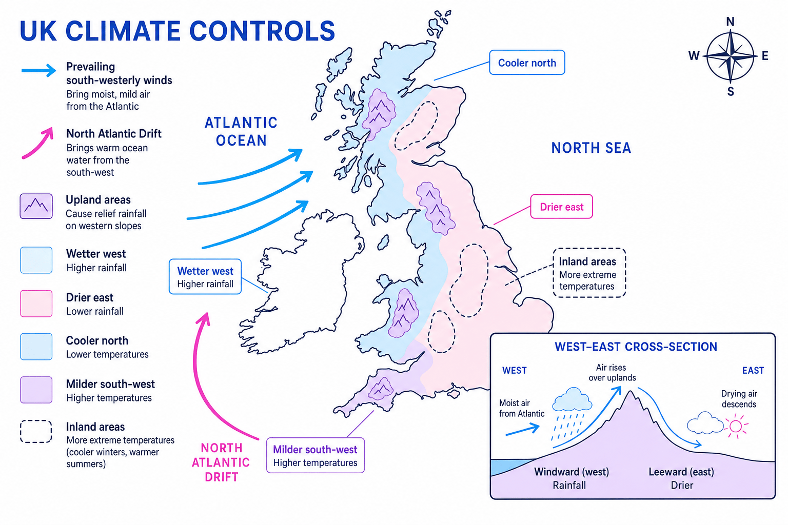
The south is generally warmer than the north because it is closer to the Equator. Coastal areas are often milder than inland areas because the sea heats up and cools down more slowly than land. Upland areas, such as the Scottish Highlands, are colder because temperature usually decreases with altitude.
Rainfall variation
The west of the UK is generally wetter than the east. Prevailing south-westerly winds bring moist air from the Atlantic. When this air reaches upland areas in Wales, western Scotland, north-west England and south-west England, it is forced to rise. This causes relief rainfall.
Wind variation
The UK lies in the belt of prevailing westerly winds between around 30° and 60° north. Its position on the western edge of Europe means Atlantic air masses often reach the UK first, making the weather changeable.
Explaining why western UK is wetter than eastern UK
- Prevailing south-westerly winds bring moist air from the Atlantic Ocean towards the UK.
- In western upland areas, the air is forced to rise, cool and condense, producing relief rainfall.
- After crossing the uplands, the air descends towards the east, becomes warmer and drier, creating a rain-shadow effect.
A useful UK climate chain
For UK rainfall, think: Atlantic moisture → south-westerly winds → upland rise → cooling and condensation → wetter west, drier east.
In the exam
- Link causes to effects clearly: for example, “air rises, cools and condenses, so rainfall increases.”
- Use named places when you can, such as the Sahara for 30° desert belts, Bangladesh for sea-level risk, or the Alps for glacier retreat.
- For graph questions, quote data carefully, calculate change if needed, and describe the overall trend before explaining it.
Check yourself
- Why does low pressure at the Equator usually lead to heavy rainfall?
- How do Milankovitch cycles differ from volcanic eruptions as causes of climate change?
- Why is the west of the UK generally wetter than the east?
