

What you'll learn
- How to describe the characteristics, distribution and measurement of tropical cyclones, earthquakes and volcanoes.
- Why tropical cyclones need warm oceans, low pressure, low wind shear and the Coriolis force.
- How plate boundaries and hotspots create earthquake and volcanic hazards.
- How to use named places, such as Japan, Iceland, Hawaii and the Philippines, to support your explanations.
1. What is a natural hazard?
A natural hazard is a natural event that could threaten people, property or the environment. It only becomes a major problem when it affects people or places we value.
Natural hazard
A natural hazard is a naturally occurring event, such as an earthquake, volcanic eruption or tropical cyclone, that has the potential to cause damage, injury, death or disruption.
A remote volcanic eruption in an uninhabited area is still a hazard, but it may not become a disaster. A disaster happens when the event causes serious impacts on people and society.
You can think of hazard risk like this:
Risk≈hazard magnitude×exposure×vulnerability\text{Risk} \approx \text{hazard magnitude} \times \text{exposure} \times \text{vulnerability}Risk≈hazard magnitude×exposure×vulnerabilityExposure means how many people, buildings and services are in harm’s way. Vulnerability means how likely they are to be badly affected, often linked to poverty, building quality, warning systems and preparedness.
Hazard does not just mean disaster
Do not write as if the natural event alone causes the disaster. A powerful earthquake in a well-prepared country may kill fewer people than a smaller earthquake in a more vulnerable country.
2. The main natural hazards in this section
For Edexcel IGCSE Geography, this key idea focuses on three major hazard types.
Tropical cyclones
A tropical cyclone is a large rotating storm that forms over warm tropical oceans. It has very strong winds, heavy rainfall, low pressure and often a storm surge.
The same type of storm has different regional names:
- Hurricane: Atlantic Ocean and north-east Pacific.
- Typhoon: north-west Pacific, for example near Japan and the Philippines.
- Cyclone: Indian Ocean and south Pacific, for example near Bangladesh or Mozambique.
Earthquakes
An earthquake is a sudden shaking of the ground caused by energy being released inside the Earth, usually when rocks suddenly slip along a crack called a fault.
The point underground where the earthquake starts is the focus. The point directly above it on the surface is the epicentre.
Volcanoes
A volcano is an opening in the Earth’s crust where molten rock, ash and gases can erupt. Molten rock underground is called magma. Once it reaches the surface, it is called lava.
Primary and secondary hazards
A primary hazard is the direct effect of the event, such as ground shaking, lava flows or strong winds. A secondary hazard is triggered by the first event, such as a tsunami after an earthquake, lahars after an eruption, or flooding after a tropical cyclone.
3. Characteristics of natural hazards
When you describe a hazard, do not only name it. Geographers look at its characteristics.
| Characteristic | Meaning | Example |
|---|---|---|
| Magnitude | The size or energy of the event | A magnitude 7 earthquake releases far more energy than magnitude 6 |
| Frequency | How often it happens | The Philippines experiences many tropical cyclones each year |
| Duration | How long it lasts | Earthquake shaking may last seconds; flooding after a cyclone may last days |
| Speed of onset | How quickly it begins | Earthquakes are sudden; some volcanic eruptions give warning signs |
| Areal extent | The area affected | A cyclone can affect hundreds of kilometres of coastline |
| Predictability | How well it can be forecast | Cyclone tracks can often be forecast; exact earthquake timing cannot |
Describe, then explain
For higher marks, move beyond “there was an earthquake”. Say what kind of hazard it was, how strong it was, where it happened, and why that location was at risk.
4. Distribution: where hazards happen
Natural hazards are not randomly spread. They cluster in particular zones because of physical processes.
Tropical cyclones mainly form over warm tropical oceans between about 5° and 30° north and south of the Equator. They are rare at the Equator because the Coriolis force is too weak, and they weaken over land because they lose their warm ocean energy source.
Earthquakes occur mostly along plate boundaries, especially around the Pacific Ring of Fire, the Mid-Atlantic Ridge, the Himalaya collision zone and major transform faults such as the San Andreas Fault in California.
Volcanoes are also common along plate boundaries, especially destructive and constructive boundaries. They also occur at hotspots, such as Hawaii, where magma rises through the middle of a plate.
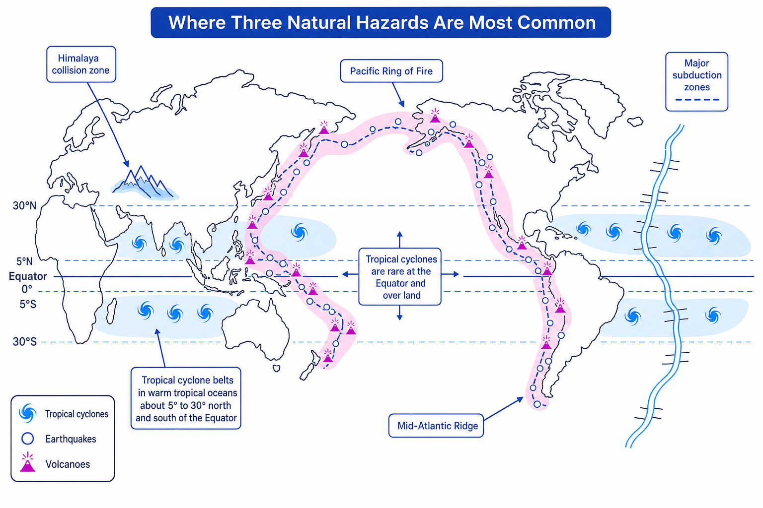
Explaining why the Philippines is hazard-prone
- Use its location: The Philippines lies in the western Pacific, within the tropical cyclone belt between about 5° and 30° north of the Equator.
- Link to atmospheric hazards: Warm ocean water in this region helps tropical cyclones form and intensify, bringing high winds, heavy rain and storm surges.
- Link to tectonic hazards: The Philippines also lies on the Pacific Ring of Fire, close to subduction zones, so it faces earthquakes and volcanic eruptions as well as cyclones.
Use distribution words
Good map descriptions use phrases like clustered along, concentrated near, between 5° and 30°, mostly coastal, rare at the Equator, and associated with plate boundaries.
5. Measuring natural hazards
Different hazards are measured in different ways.
| Hazard | Common measurement | What it tells you |
|---|---|---|
| Tropical cyclone | Saffir-Simpson scale, categories 1 to 5 | Based on sustained wind speed |
| Tropical cyclone | Central pressure in hPa | Lower pressure usually means a stronger storm |
| Tropical cyclone | Rainfall in mm and storm surge height in m | Helps show flood risk |
| Earthquake | Moment magnitude or Richter scale | Measures energy released |
| Earthquake | Mercalli scale | Measures observed damage and effects |
| Volcano | Volcanic Explosivity Index, VEI 0 to 8 | Measures explosiveness using erupted material, plume height and duration |
The Saffir-Simpson Hurricane Wind Scale classifies storms from Category 1 to Category 5. Category 1 begins at sustained winds of 119 km/h. Category 5 storms have sustained winds of at least 252 km/h.
The Moment Magnitude scale is now widely used for earthquakes, though you may still see the older term Richter scale in textbooks. Both are magnitude scales. The Mercalli scale is different: it measures the intensity of shaking and damage at a particular place.
Magnitude and intensity are not the same
An earthquake has one magnitude, but its intensity varies from place to place. Areas closer to the epicentre, on soft ground, or with weaker buildings usually experience greater damage.
Classifying a tropical cyclone from wind speed
A storm has sustained winds of 210 km/h.
- Compare the value with the category boundaries: Category 3 is 178–208 km/h, while Category 4 is 209–251 km/h.
- Choose the correct category: 210 km/h is just above 209 km/h, so the storm is Category 4.
- Add a hazard implication: A Category 4 storm can cause severe wind damage, coastal flooding from storm surge and disruption to power, transport and communications.
6. Why tropical cyclones form
Tropical cyclones need a very specific set of conditions.
Warm ocean water
Sea surface temperatures usually need to be about 27°C or higher. Warm water increases evaporation, which is the change of liquid water into water vapour. This gives the storm a supply of warm, moist air.
Low atmospheric pressure
Atmospheric pressure is the force of air pressing down on the Earth’s surface. In a developing tropical cyclone, warm moist air rises, leaving lower pressure at the surface. Air then rushes inward to replace it.
Condensation and latent heat
As moist air rises, it cools and condenses into clouds and rain. Latent heat is energy released during condensation. This heat makes the air rise even more strongly, powering the storm.
Low wind shear
Wind shear means a change in wind speed or direction with height. Tropical cyclones need low vertical wind shear so the storm can stay upright and organised. Strong wind shear can tilt the storm and tear it apart.
Coriolis force
The Coriolis force is the apparent deflection of moving air caused by the Earth’s rotation. It helps the air spiral around the low-pressure centre. It is too weak at the Equator, which is why tropical cyclones rarely form there.
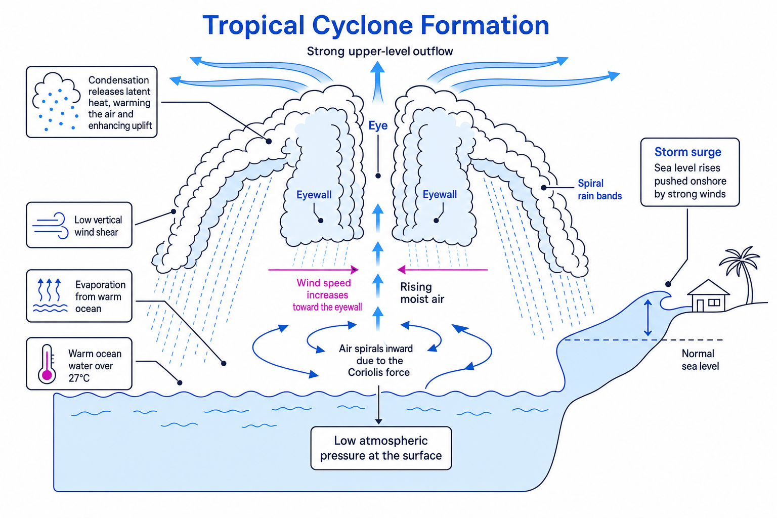
Checking whether a tropical cyclone can form
A weather system is over ocean water of 28°C at 12°N. Surface pressure is falling, and vertical wind shear is low.
- Check the heat supply: 28°C is warm enough to provide strong evaporation and moist rising air.
- Check the rotation condition: 12°N is far enough from the Equator for the Coriolis force to help the storm spin.
- Check storm organisation: Low wind shear means the rising air columns are less likely to be tilted apart, so the system could develop into a tropical cyclone.
Forgetting the Equator problem
Warm water alone is not enough. Tropical cyclones rarely form right on the Equator because the Coriolis force is too weak to create organised rotation.
7. Why earthquakes and volcanoes happen
The Earth’s outer shell is broken into large slabs called tectonic plates. These plates move slowly, usually only a few centimetres per year, but their movement creates huge stress.
A plate boundary is the edge where two plates meet. Most earthquakes and volcanoes occur at or near these boundaries.
Constructive plate boundaries
At a constructive boundary, plates move apart. Magma rises to fill the gap, cools and forms new crust. This can create volcanoes and shallow earthquakes.
Example: Iceland lies on the Mid-Atlantic Ridge, where the North American and Eurasian plates move apart.
Destructive plate boundaries
At a destructive boundary, usually an oceanic plate moves towards a continental plate. The denser oceanic plate is forced down into the mantle in a process called subduction.
As the plate sinks, it melts and magma rises, forming volcanoes. Stress also builds up along the boundary, causing earthquakes. These earthquakes can be shallow, intermediate or deep.
Example: Japan and Indonesia are affected by destructive plate boundaries around the Pacific Ring of Fire.
Conservative plate boundaries
At a conservative boundary, plates slide past each other. They often get stuck, pressure builds, and then they suddenly slip, causing earthquakes. Volcanoes are not usually found here because magma is not being created or forced upwards.
Example: the San Andreas Fault in California.
Collision zones
At a collision zone, two continental plates push into each other. Neither plate easily sinks, so the crust crumples and thickens, forming fold mountains. Earthquakes are common, but volcanoes are rare.
Example: the Himalayas, formed by the collision of the Indian and Eurasian plates.
Hotspots
A hotspot is an area where magma rises from deep within the mantle, away from a plate boundary. As a plate moves over the hotspot, a chain of volcanoes can form.
Example: Hawaii is a chain of volcanic islands formed as the Pacific Plate moves over a hotspot.
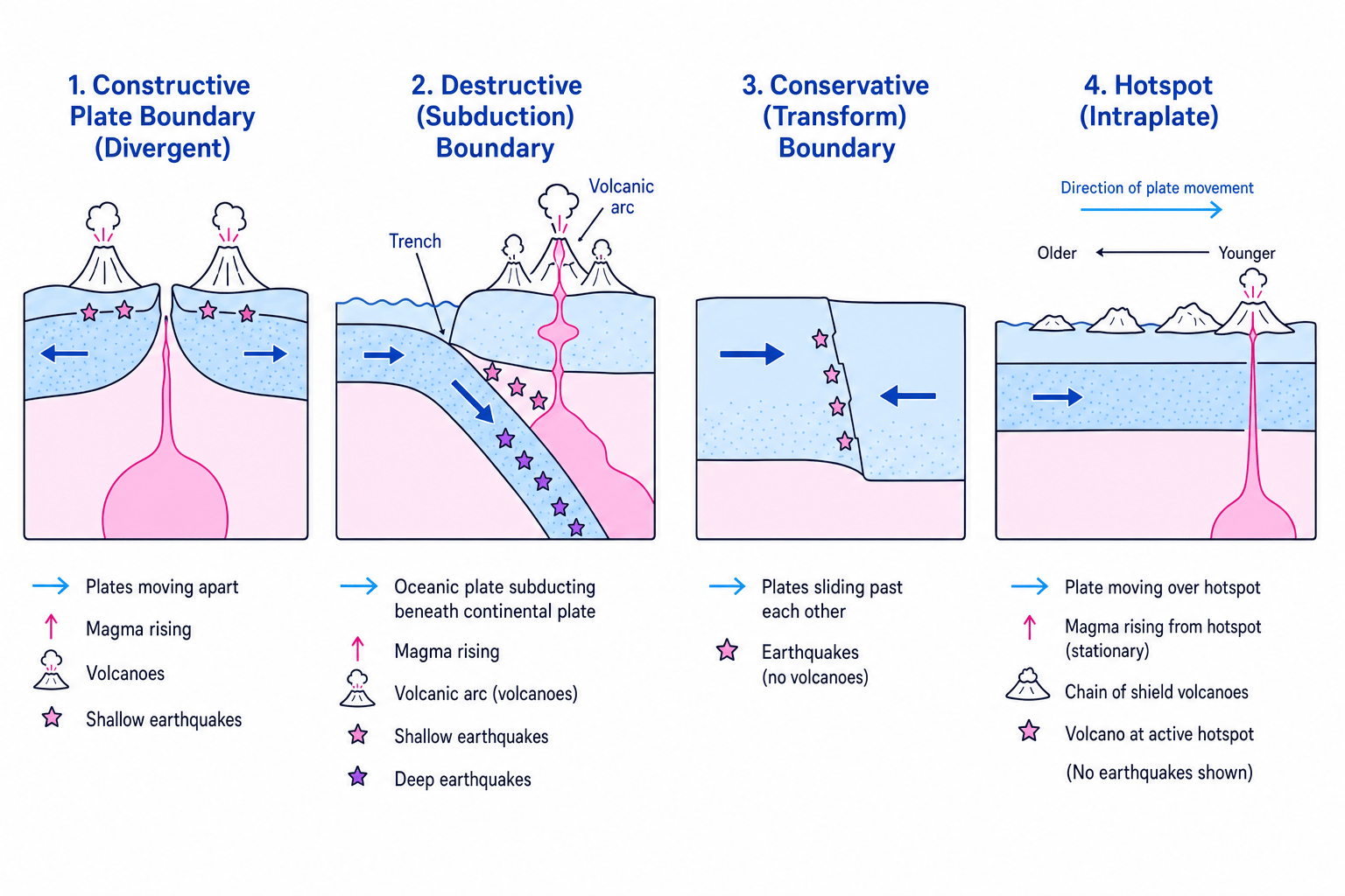
Identifying hazards at a plate boundary
The Nazca Plate is moving beneath the South American Plate along the west coast of South America.
- Identify the boundary type: One oceanic plate is being forced beneath another plate, so this is a destructive subduction boundary.
- Infer the earthquake hazard: Stress builds as the plates lock and then suddenly slip, causing powerful earthquakes.
- Infer the volcanic hazard: The subducted plate melts, magma rises through the continental crust, and volcanoes form in the Andes.
Why some places are more hazardous
Places are more hazardous when they lie in physical hazard zones, such as tropical cyclone belts, plate boundaries or hotspots. Risk becomes even higher where many people and important infrastructure are exposed.
8. Bringing it together
Some countries face multiple hazards because their physical geography overlaps. For example:
- Japan lies on the Pacific Ring of Fire, so it experiences earthquakes, volcanoes and tsunami risk.
- The Philippines lies in both a tropical cyclone belt and a tectonically active zone.
- Iceland has earthquakes and volcanoes because it sits on a constructive plate boundary.
- Hawaii has volcanoes because it lies over a hotspot, even though it is not on a plate boundary.
In exam answers, named examples help you show geographical understanding. You do not need exact statistics for every place, but you should use accurate locations and processes.
In the exam
- Name the hazard and measure it correctly: Use wind speed and category for tropical cyclones, magnitude or Mercalli intensity for earthquakes, and VEI for volcanoes.
- Link distribution to process: Do not just say “near the coast” or “near plates”; explain warm oceans, Coriolis force, subduction, plate movement or hotspots.
- Use located examples: Refer to real places such as Japan, the Philippines, Iceland, Hawaii, the Andes or the San Andreas Fault to support your explanation.
Check yourself
- Why do tropical cyclones rarely form at the Equator even when the sea is warm?
- What is the difference between earthquake magnitude and intensity?
- Which plate boundaries usually produce volcanoes, and which usually do not?
