

What you'll learn
- Why coasts matter for homes, jobs, ecosystems and transport.
- How different coastal users can come into conflict over conservation and development.
- Why coastal flooding happens through storm surges, tsunamis and climate change.
- How hard engineering, soft engineering and shoreline management plans are used in real places.
1. Why coasts need management
The coast is the zone where land and sea meet. It is valuable because people use it for housing, ports, fishing, farming, energy, tourism and transport. It is also environmentally valuable: dunes, beaches, saltmarshes and mangroves can be habitats for wildlife and natural flood buffers.
Coastal management
Coastal management means making decisions and taking actions to reduce coastal erosion and flooding while balancing the needs of people, the economy and the environment.
Sustainable management means meeting today’s needs without damaging the ability of future generations to meet theirs. At the coast, that often means asking: “Can we afford this? Will it last? Does it protect one place by damaging another?”
The big idea
Coastal management is not just about stopping the sea. It is about choosing the fairest and most sustainable option for a particular place.
2. Conflicts between coastal users
A stakeholder is a person or group affected by a decision. Coasts have many stakeholders, so conflicts are common.
- Residents may want sea walls to protect homes.
- Tourism businesses may want wide sandy beaches and promenades.
- Farmers may want farmland protected from erosion or flooding.
- Conservationists may want natural dunes, saltmarshes or mangroves left undisturbed.
- Local councils and taxpayers may worry about high defence costs.
- Developers may want new hotels, housing or roads near the sea.
Two main viewpoints often clash:
- Development means using the coast for economic growth, such as tourism, ports, housing or industry.
- Conservation means protecting natural environments and allowing coastal systems to function with less human interference.
Explaining a coastal conflict
- At Mappleton on the Holderness Coast, UK, rock groynes and rock armour were built to protect the village and the B1242 road, so residents and road users gained protection.
- The groynes trapped sediment moving south by longshore drift, leaving less beach material for places down-drift such as Great Cowden.
- This creates conflict because one group benefits from protection, while down-drift landowners may face faster erosion and taxpayers may question whether defending a small settlement is worth the cost.
3. Causes of coastal flooding
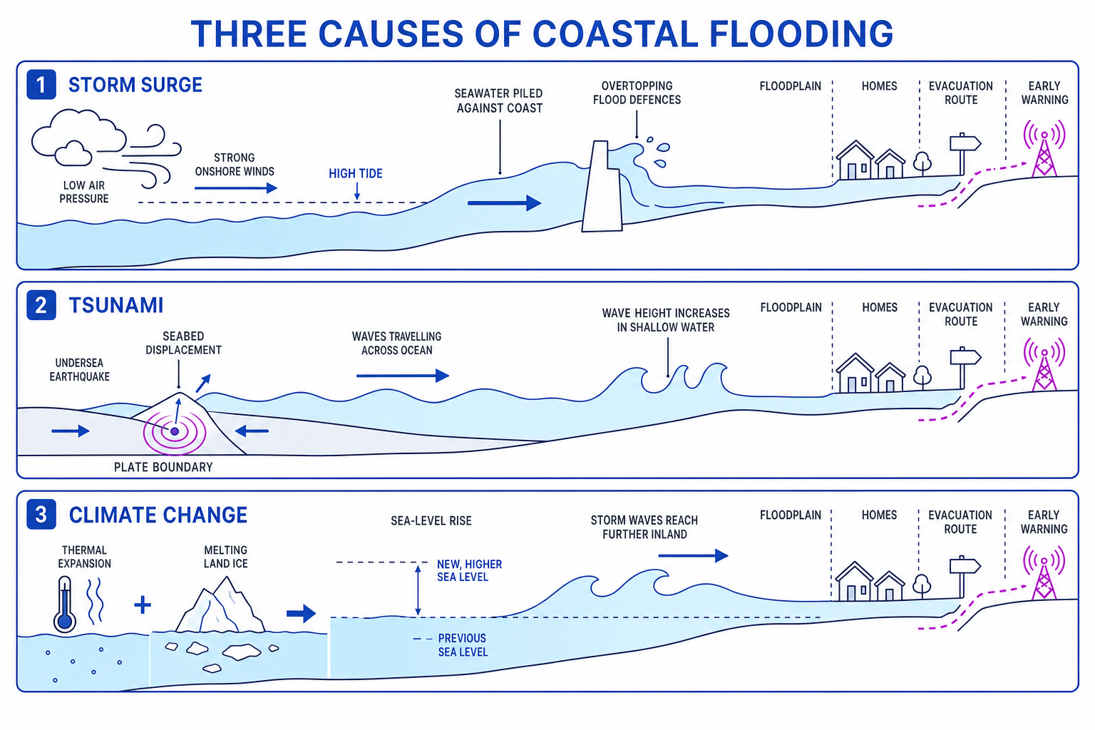
Coastal flooding happens when seawater covers normally dry land. It can be sudden, such as during a storm surge or tsunami, or become more likely over time as sea level rises.
Storm surges
A storm surge is a temporary rise in sea level caused by low air pressure and strong onshore winds pushing water towards the coast. Flood risk is worse if the surge arrives at high tide, especially in shallow or funnel-shaped seas. The 1953 North Sea storm surge caused serious flooding in eastern England and the Netherlands.
Tsunamis
A tsunami is a series of large waves usually caused by an undersea earthquake, volcanic eruption or landslide. In deep ocean the waves may be low but fast; near the coast, shallower water makes them slow down and grow taller. The 2004 Indian Ocean tsunami is a major named example.
Climate change
Climate change is the long-term change in global climate patterns, mainly linked today to rising greenhouse gas concentrations. It increases coastal flood risk because:
- warmer seawater expands, raising sea level;
- melting land ice adds water to the oceans;
- a higher sea level means storm waves and surges can reach further inland.
Tsunamis are not storm waves
Tsunamis are not caused by wind, so weather forecasts cannot predict them days ahead. Warning systems detect earthquakes, sea-level changes and ocean-buoy signals, then issue evacuation alerts.
4. Predicting and reducing coastal flooding
Prediction means estimating when and where flooding may occur. Prevention is often really risk reduction, because no coast can be made completely flood-proof.
Useful methods include:
- Forecasting: satellites, weather models, tide gauges and storm-surge models predict high-risk conditions. Tsunami systems use seismometers, ocean buoys and tide gauges.
- Building design: homes may be raised on stilts or plinths, use flood-resistant materials, or have sacrificial ground floors. Cyclone shelters are often built on raised ground.
- Planning: governments can create setback zones, avoid building on low-lying floodplains, protect dunes and mangroves, and mark evacuation routes.
- Education: warning sirens, school drills, hazard maps, text alerts and community volunteers help people know what to do quickly.
Assuming defences remove all risk
Sea walls, embankments and shelters reduce risk, but extreme events can still overtop, breach or bypass them. In evaluation, say “reduces flood risk” rather than “stops flooding forever”.
5. Coastal management strategies
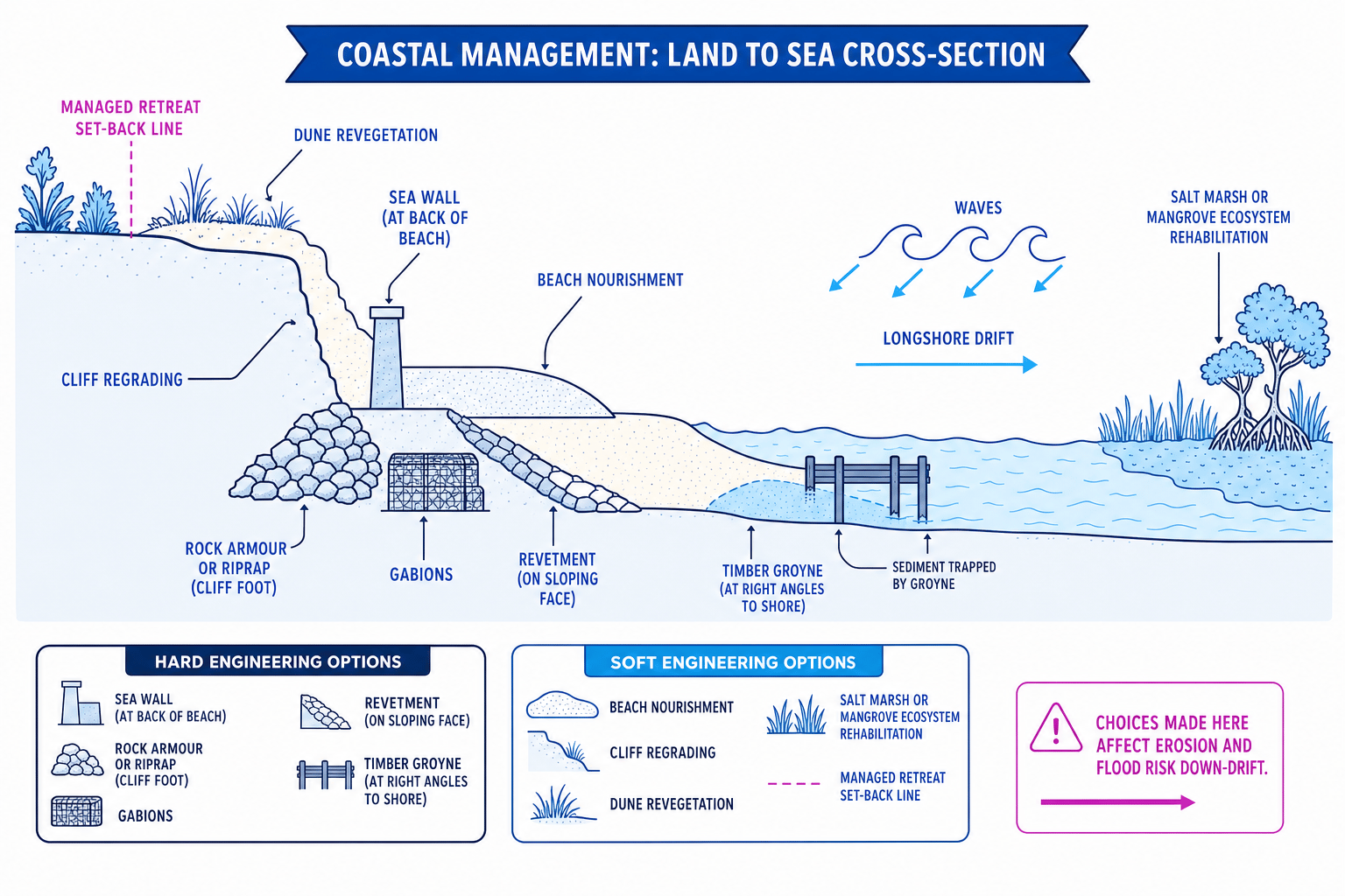
Coastal defences are often grouped into hard engineering and soft engineering. The diagram below shows the main options you need to recognise and evaluate.
Hard and soft engineering
- Hard engineering uses built structures to resist waves, erosion or flooding.
- Soft engineering works more with natural processes, often by adding sediment, restoring ecosystems or giving the sea more space.
Hard engineering
- Sea walls: concrete walls that reflect or absorb wave energy; effective but expensive and can increase beach scouring.
- Groynes: barriers built at right angles to the coast to trap sediment moved by longshore drift; they widen beaches but may starve down-drift areas.
- Revetments: sloping wooden, rock or concrete barriers that absorb wave energy.
- Gabions: wire cages filled with rocks; cheaper, but can rust and look unattractive.
- Riprap, also called rock armour: large boulders placed at the cliff foot or shore to absorb wave energy.
Soft engineering
- Beach replenishment or nourishment: adding sand or shingle to make a beach wider, so it absorbs wave energy.
- Cliff regrading: reducing the cliff angle to make collapse less likely, often combined with drainage.
- Ecosystem rehabilitation: restoring habitats such as saltmarshes, dunes or mangroves so they absorb wave energy and store sediment.
- Revegetation: planting vegetation, such as marram grass on dunes or mangroves in tropical coasts, to stabilise sediment.
- Managed retreat: deliberately allowing some low-value land to flood or erode, often creating saltmarsh as a natural buffer.
Forgetting down-drift effects
A defence can protect one place but increase erosion elsewhere. Always check what happens to sediment movement along the coast.
Choosing a management strategy
- If a coastline has low-value farmland, important saltmarsh habitat and rising sea level, building an expensive sea wall may protect land short term but could squeeze out the saltmarsh.
- Managed retreat would allow seawater onto selected land, creating a wider natural flood buffer and reducing long-term maintenance costs.
- The most sustainable choice may be managed retreat with compensation for landowners, because it balances cost, flood protection and habitat creation.
6. Shoreline management plans
A shoreline management plan or SMP is a long-term plan for managing a stretch of coastline, often over 20, 50 and 100 years. It considers whole sediment cells, which are sections of coast where sediment movement is mostly contained.
Typical SMP policies are:
- Hold the line: keep the coastline in its current position using defences.
- Advance the line: build new defences further seaward.
- Managed realignment: move defences inland or allow controlled flooding.
- No active intervention: allow natural processes to continue without major new defences.
SMPs are important because defending everywhere is usually too expensive and may be environmentally damaging.
7. 🌐 Case studies: two contrasting countries
For Edexcel, you need coastal-management case studies in a developed country and a developing or emerging country. The two below are strong examples because they show different levels of wealth, risk and management capacity.
Developed country case study: Holderness Coast, UK
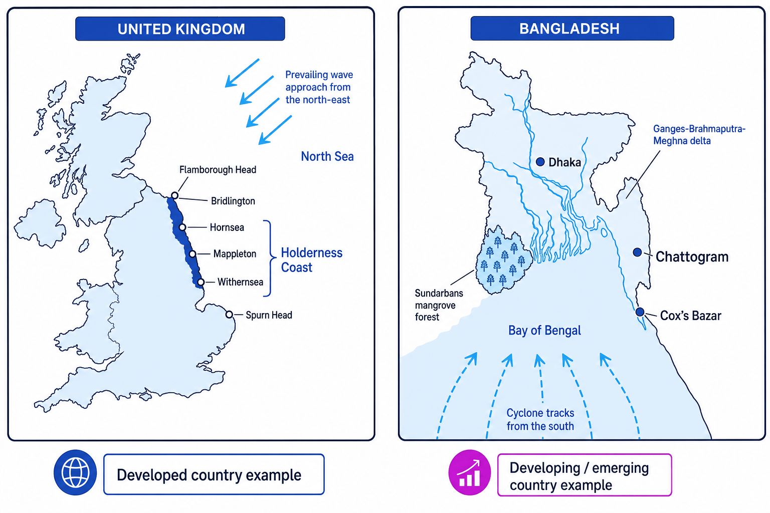
The Holderness Coast is on the east coast of Yorkshire, facing the North Sea. The UK is a high-income developed country with formal planning systems and shoreline management plans.
Holderness is one of Europe’s fastest-eroding coastlines, commonly quoted at around 1–2 metres per year on average, though rates vary. Erosion is rapid because cliffs are made from soft glacial till, beaches can be narrow, and destructive North Sea waves attack the coast.
Management includes:
- Mappleton: rock groynes and rock armour built in 1991, costing about £2 million, to protect the village and B1242 road.
- Hornsea and Withernsea: sea walls, groynes and promenades protect larger settlements and tourism.
- Rural stretches: often have no active intervention because the cost of protection is higher than the value of land.
The key issue is sustainability. Defences protect people and infrastructure, but groynes interrupt sediment movement and can worsen erosion down-drift.
Developing/emerging country case study: Bangladesh coast
Bangladesh is a densely populated lower-income country on the Ganges-Brahmaputra-Meghna delta, facing the Bay of Bengal. Much of the coast is low-lying, so cyclones and storm surges are major hazards.
Management includes:
- Cyclone forecasting and warnings through the Cyclone Preparedness Programme, radio, mobile alerts and community volunteers.
- Cyclone shelters on raised ground, often used as schools or community buildings outside emergencies.
- Embankments and polders to protect farmland and settlements, although they can be breached and need maintenance.
- Mangrove protection and replanting, especially around the Sundarbans, which helps absorb wave energy and provides habitat.
- Education and evacuation drills so people know where to go before a cyclone arrives.
Bangladesh shows that sustainable coastal management is not only about expensive concrete defences. Warnings, shelters, education and ecosystem protection can save many lives, although poverty, population pressure and sea-level rise make management difficult.
In the exam
- Name the place and country, then add national context: developed, developing or emerging.
- Link process to management: explain how waves, longshore drift, storm surges or sea-level rise create the problem.
- Evaluate sustainability by considering cost, maintenance, winners and losers, environmental impacts and down-drift effects.
Check yourself
- Why can protecting one coastal settlement increase conflict further down the coast?
- How are storm surges, tsunamis and climate-change sea-level rise different?
- For one case study, which management strategy is most sustainable, and why?
