

What you'll learn
- Why rivers are valuable for water supply, farming, industry, hygiene and leisure.
- Why some places have water surplus while others face water shortage.
- How pollution, treatment works, dams and pipelines affect water quality.
- Why rivers flood, how hydrographs help predict floods, and how management differs in a developed and a developing country.
The big idea: rivers as resources and risks
A river environment includes the river channel, banks, floodplain, nearby settlements, ecosystems and the wider land area draining into the river. Rivers are useful because they provide water and transport sediment and nutrients, but they can also create hazards such as flooding and pollution.
Sustainable river management
Sustainable river management means using and controlling rivers in a way that meets people’s needs now, while protecting ecosystems and not increasing risks or costs for future generations.
Balance is the key
A river is not just a “water pipe”. It is a natural system. Management works best when it balances social needs, economic benefits and environmental impacts.
Uses of water
People use river water directly from channels, reservoirs and groundwater connected to rivers. The main uses in this topic are:
| Use | What it includes | Why it matters |
|---|---|---|
| Agriculture | Irrigation, livestock, washing crops | Food production; often the largest water user globally |
| Industry | Cooling machinery, manufacturing, cleaning, energy production | Jobs and economic growth |
| Human hygiene | Drinking, handwashing, sanitation, washing clothes | Public health and quality of life |
| Leisure | Fishing, boating, riverside tourism, walking | Wellbeing and local income |
Rising demand for water
Water demand means the amount of water people want or need. Demand is rising because populations are growing, cities are expanding, people use more appliances, industries need water, and diets often shift towards more water-intensive foods such as meat and dairy.
Water supply means the amount of water available for use. Supply depends on rainfall, river flow, geology, reservoirs, pipelines and treatment capacity. Supply can be increased by building reservoirs, transferring water through pipelines, recycling water, treating wastewater or, in some coastal countries, using desalination.
Water surplus and water shortage
A water surplus happens when supply is greater than demand. A water shortage happens when demand is greater than reliable supply, either because there is physically little water or because people cannot access clean water.
For example, the UK often has a north-west/south-east contrast: upland areas of Scotland, Wales and northern England tend to have higher rainfall and lower population density, while south-east England has lower rainfall but very high demand from London and surrounding towns.
Calculating rising water demand
A town’s water demand rises from 120 million litres per day to 150 million litres per day.
-
Choose the correct percentage-change formula:
percentage change=new value−old valueold value×100\text{percentage change} = \frac{\text{new value} - \text{old value}}{\text{old value}} \times 100percentage change=old valuenew value−old value×100 -
Substitute the values:
150−120120×100=25%\frac{150 - 120}{120} \times 100 = 25\%120150−120×100=25% -
Interpret the result geographically: demand has risen by 25%, so the town may need extra storage, reduced leakage, water-saving measures or new supply routes.
Water quality: why clean water varies
Water quality means how clean and safe water is for people and ecosystems. High-quality water is low in harmful chemicals, bacteria and suspended waste. Potable water is water that is safe to drink.
The main pollution sources in the specification are:
- Sewage: human waste and dirty water from homes. Untreated sewage can add bacteria and organic matter, reducing oxygen in the water.
- Industrial waste: chemicals, oils, heavy metals or heated water from factories and power stations.
- Agriculture: fertiliser, pesticides and slurry washed from fields into rivers by rain.
Agricultural pollution can cause eutrophication. This is when excess nutrients, especially nitrates and phosphates, cause rapid algal growth. When algae die, decomposers use up dissolved oxygen, which can kill fish and other aquatic life.
Clean water supply usually needs storage, movement and treatment: dams and reservoirs store water, pipelines transfer it, and treatment works remove solids, kill harmful microbes and make water safe to use.
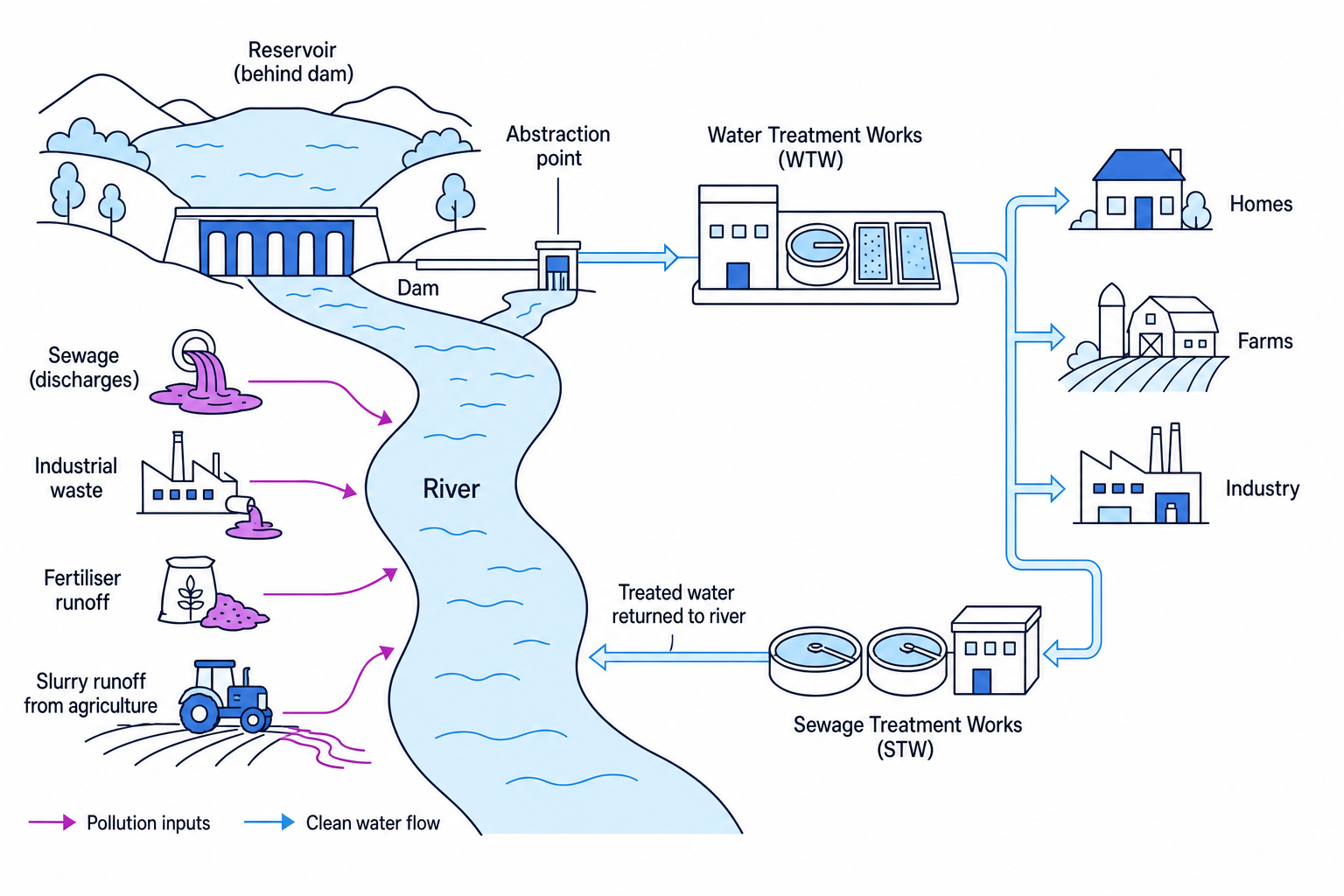
Identifying a likely pollution source
A river sample downstream of farmland has high nitrate levels, an algal bloom and low dissolved oxygen.
-
Link the evidence to a source: high nitrates are strongly associated with fertiliser and slurry runoff from agriculture.
-
Apply the process: nutrients encourage algal growth; when algae die and decay, decomposers use up oxygen.
-
Make the conclusion: agriculture is the most likely pollution source, and the low oxygen means fish and invertebrates may be at risk.
Confusing water quantity and water quality
A river can have plenty of water but still be unsafe to use. In geography, always separate how much water is available from how clean it is.
Why rivers flood
A flood happens when a river’s discharge becomes too large for its channel and water spills onto the floodplain, the flat land beside the river.
Discharge
Discharge is the volume of water passing a point in a river each second. It is usually measured in cubic metres per second, written as m³/s.
Main causes of flooding
Rainfall intensity matters because heavy rain can fall faster than soil can absorb it. This increases surface runoff, which is water flowing over the ground into streams and rivers.
Seasonal discharge varies in some regions. In monsoon climates, months of intense seasonal rain can greatly increase river flow. In mountain areas, spring or early summer snowmelt can add large amounts of water to rivers.
Relief means the shape and steepness of the land. Steep slopes move water quickly into river channels, creating a short lag time and high flood risk. Low-lying land may flood because water drains away slowly.
Urbanisation increases flood risk because roads, roofs and pavements are impermeable surfaces, meaning water cannot soak into them. Drains also move water into rivers quickly.
A storm hydrograph shows how a river’s discharge changes after rainfall. It helps geographers compare flood risk in different drainage basins.
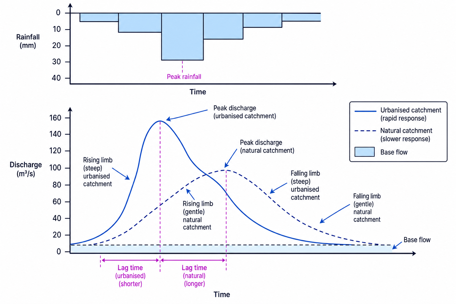
Reading flood risk from a hydrograph
A natural catchment peaks at about 95 m³/s with a lag time of 8 hours. An urbanised catchment peaks at about 160 m³/s with a lag time of 4 hours.
-
Compare peak discharge: the urbanised catchment has the higher peak, so more water reaches the river channel at once.
-
Compare lag time: the urbanised catchment peaks sooner, giving people and emergency services less warning time.
-
Apply this to risk: the urbanised catchment is more likely to experience a rapid, damaging flood because discharge rises quickly and reaches a higher maximum.
Predicting and preventing floods
Floods cannot always be prevented, but their impacts can be reduced. Prediction uses weather forecasts, rain gauges, river-level gauges, radar, satellites and computer models. These feed into warning systems, evacuation plans and emergency responses.
Hard engineering means building structures to control rivers, such as dams, reservoirs, embankments, flood walls and flood-relief channels. These can protect valuable urban areas but are expensive and may transfer risk downstream.
Soft engineering works more with natural processes. Examples include floodplain zoning, washlands, wetland restoration, afforestation and sustainable drainage systems in cities. These often have lower environmental impact, but they may need more land and may not protect against extreme events.
Prevention does not mean zero risk
In geography, “flood prevention” usually means reducing the probability or impact of flooding. Extreme rainfall, blocked drains or failed defences can still cause floods.
Case study: river management in a developed country — River Thames, UK
🌐 The UK is a developed, high-income country with strong engineering capacity and dense urban development. The River Thames flows through London, a global city of about 9 million people, so flood protection and water quality are nationally important.
Key management strategies include:
- The Thames Barrier, flood walls and forecasting systems, which reduce the risk of tidal and river flooding in London.
- The Jubilee River, an 11.6 km flood-relief channel near Maidenhead, Windsor and Eton, which diverts some floodwater away from settlements.
- Upgrades to sewage treatment and the Thames Tideway Tunnel, designed to reduce sewage overflows into the river.
- Increasing use of floodplain planning, wetlands and sustainable drainage in parts of the catchment.
This management is effective because it protects very high-value land and infrastructure. However, it is expensive, needs constant maintenance and must adapt to climate change and sea-level rise.
Case study: river management in a developing country — Bangladesh
🌐 Bangladesh is a densely populated lower-middle-income country on the Ganges-Brahmaputra-Meghna delta. Much of the country is low-lying, and river flooding is linked to monsoon rainfall, Himalayan snowmelt and sometimes cyclones. Floods can be disastrous, but they also deposit fertile silt for farming.
Management includes:
- Embankments and polders to protect farmland and settlements.
- Flood forecasting and warning systems run through national agencies and local communication networks.
- Raised homes, raised tube wells, flood shelters and evacuation routes.
- Community preparedness, flood-resistant crops and adapting to seasonal flooding.
These approaches are more affordable than relying only on large engineering schemes. However, embankments can fail, trap water, stop natural silt deposition and require maintenance. A sustainable approach in Bangladesh often means reducing deaths and damage while accepting that some flooding is natural and useful.
Comparing case studies
For each case study, remember context, actions, benefits, problems. Developed-country schemes often show expensive engineering and strong forecasting; developing-country schemes often show a mix of low-cost adaptation, community action and selective hard engineering.
In the exam
- Use precise terms: write demand, supply, water quality, discharge, lag time and floodplain accurately.
- When using a case study, name the river and country, then add national context before evaluating the management.
- For hydrographs, compare both peak discharge and lag time before deciding which river basin has greater flood risk.
Check yourself
- Why might south-east England face water shortages even though the UK is a relatively wet country?
- How can fertiliser runoff lead to fish deaths in a river?
- Why does urbanisation usually make a storm hydrograph “flashier”?
