

What you'll learn
- How erosion, weathering, mass movement, transportation and deposition shape river channels and valleys.
- How a river’s width, depth, velocity, discharge and sediment change from source to mouth.
- How classic river landforms form, including V-shaped valleys, interlocking spurs, waterfalls, meanders, oxbow lakes, floodplains and levees.
- How to use the River Tees, North East England as a located river example.
Start with the river as a system
A river channel is the hollow or route that the river flows in. The bed is the bottom of the channel, and the banks are the sides. A river valley is the wider low area shaped by the river and processes on the valley sides.
The source is where a river begins, often in upland areas. The mouth is where it enters the sea, a lake or another river. The river’s course means its journey from source to mouth, usually split into the upper, middle and lower course.
Fluvial processes
Fluvial processes are river-related processes that shape the landscape: erosion, weathering, mass movement, transportation and deposition.
The main processes shaping river valleys
Erosion: wearing away rock
Erosion is the wearing away and removal of rock by moving water and the sediment it carries. Sediment means pieces of rock, sand, silt and clay carried by the river; this is also called the river’s load.
There are two important directions of erosion:
- Vertical erosion cuts down into the river bed, making the channel and valley deeper.
- Lateral erosion cuts sideways into the banks, making the channel and valley wider.
Rivers erode in several ways:
- Hydraulic action: the force of water hits banks and cracks in rock, weakening them.
- Abrasion: sediment carried by the river scrapes and wears away the bed and banks.
- Attrition: sediment particles collide with each other, becoming smaller and rounder.
- Solution: soluble minerals dissolve into the water.
Energy controls river work
A river with more energy can erode and transport more material. If it loses energy, it is more likely to deposit sediment.
Choosing vertical or lateral erosion
-
In an upper-course river such as the River Tees near the Pennines, the gradient is steep, so gravity pulls water strongly downslope and energy is focused onto the bed.
-
Because the channel is narrow and the load is often large and angular, abrasion and hydraulic action deepen the bed, so vertical erosion dominates.
-
Further downstream, the gradient is gentler but discharge is higher, so the river has enough energy to swing across its valley. Erosion is concentrated on the outside of bends, so lateral erosion becomes more important.
Weathering and mass movement: preparing material for the river
Weathering is the breakdown of rock where it is, without the material being carried away by the river. For example, freeze-thaw weathering happens when water enters cracks, freezes, expands and breaks rock apart.
Mass movement is the downslope movement of rock or soil under gravity. Examples include rockfall on steep slopes and slumping, where saturated soil slides downhill as a block.
These processes matter because they supply loose material to the river. The river can then erode it further and transport it downstream.
Weathering is not erosion
Weathering breaks rock down in place. Erosion removes material. Transportation then moves that material downstream.
Transportation and deposition
Transportation is the movement of sediment by the river. Rivers carry load in four main ways:
- Traction: large stones roll along the bed.
- Saltation: small pebbles bounce along the bed.
- Suspension: fine sediment is carried within the water.
- Solution: dissolved minerals are carried in the water.
Deposition happens when a river drops sediment because it no longer has enough energy to carry it. This often happens on the inside of meander bends, on floodplains after flooding, or near the mouth where the river enters slower water.
What affects river processes?
River processes vary from place to place. The main controls are:
| Factor | How it affects river processes |
|---|---|
| Climate | Heavy rainfall increases discharge, so erosion and transportation often increase. Cold climates can increase freeze-thaw weathering. |
| Slope / gradient | A steep gradient usually increases velocity and vertical erosion. A gentle gradient encourages lateral erosion and deposition. |
| Geology | Resistant rocks erode slowly; less resistant rocks erode faster. Permeable rock lets water pass through, while impermeable rock encourages surface runoff. |
| Altitude | Higher land is usually cooler and steeper, so freeze-thaw weathering and vertical erosion can be important. |
| Aspect | Aspect means the direction a slope faces. In the UK, north-facing slopes receive less direct sunlight, so they may stay colder and wetter for longer. |
Downstream changes: the River Tees
🌐 A useful located example is the River Tees in North East England, UK. It rises in the Pennines, near Cross Fell, and flows east for about 137 km to the North Sea at Teesmouth, near Middlesbrough and Redcar. It flows from sparsely populated uplands into the more urban and industrial Teesside area.
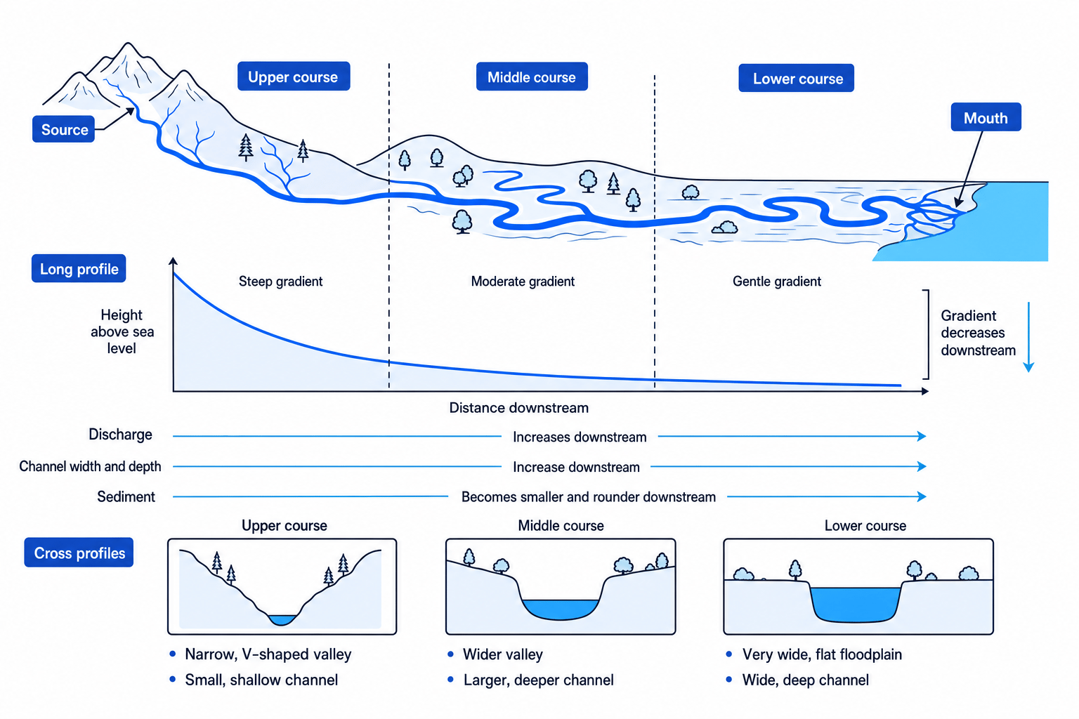
A long profile is a side view of a river from source to mouth. A cross profile is a slice across the valley or channel from one side to the other. Gradient means steepness. Velocity is the speed of the water. Discharge is the volume of water passing a point each second, usually measured in m³/s.
Typical downstream changes
In the upper course of the River Tees, the channel is narrow and shallow, the gradient is steep, and vertical erosion creates a steep-sided valley. Sediment is often large and angular.
In the middle course, the valley becomes wider and the channel becomes deeper. Tributaries join the river, increasing discharge. Sediment becomes smaller and more rounded due to attrition.
In the lower course, near Stockton-on-Tees and Middlesbrough, the river is wider and deeper with a gentler gradient. Discharge is higher, sediment is finer, and deposition becomes more important, especially on the floodplain and near the estuary.
Velocity is not just gradient
Although gradient decreases downstream, velocity often increases overall because the channel becomes deeper, wider and smoother, so there is less friction slowing the water down.
The discharge equation is:
Q=A×vQ = A \times vQ=A×vwhere QQQ is discharge, AAA is cross-sectional area, and vvv is mean velocity.
Calculating river discharge
-
If a channel is 5.0 m wide and has a mean depth of 0.4 m, estimate its cross-sectional area: A≈5.0×0.4=2.0A \approx 5.0 \times 0.4 = 2.0A≈5.0×0.4=2.0 m².
-
If mean velocity is 0.6 m/s, substitute into the discharge equation: Q=A×v=2.0×0.6Q = A \times v = 2.0 \times 0.6Q=A×v=2.0×0.6.
-
Calculate the discharge: Q=1.2Q = 1.2Q=1.2 m³/s. A downstream site would normally have a higher discharge because more tributaries and surface runoff have added water.
Upper-course landforms
V-shaped valleys
A V-shaped valley is a narrow, steep-sided valley formed mainly by vertical erosion. In the upper course, the river has a steep gradient, so it cuts down into its bed. Weathering weakens the valley sides, and mass movement moves loose material downslope. The river carries this material away, leaving a steep valley profile.
Interlocking spurs
Interlocking spurs are ridges of higher land that project into a river valley from alternating sides. In the upper course, the river has limited power for lateral erosion, so it winds around more resistant areas of land instead of cutting straight through them.
Waterfalls and gorges
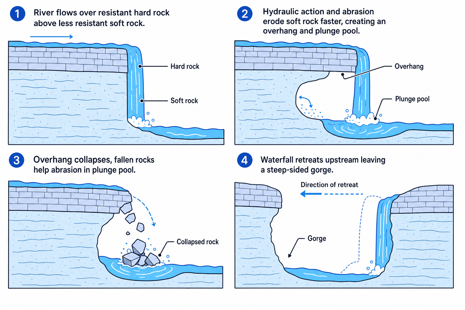
A waterfall is a sudden vertical drop in the river’s course. A gorge is a narrow, steep-sided valley often left behind as a waterfall retreats upstream. Waterfalls commonly form where resistant rock lies above less resistant rock.
Explaining waterfall retreat
-
At High Force on the River Tees, resistant rock overlies less resistant rock, so the softer rock is eroded faster by hydraulic action and abrasion.
-
This creates an undercut section and a plunge pool, which is a deep hollow at the base of the waterfall.
-
The unsupported hard rock forms an overhang and eventually collapses. Repeated collapse makes the waterfall move upstream, leaving a gorge behind.
Middle- and lower-course landforms
Meanders
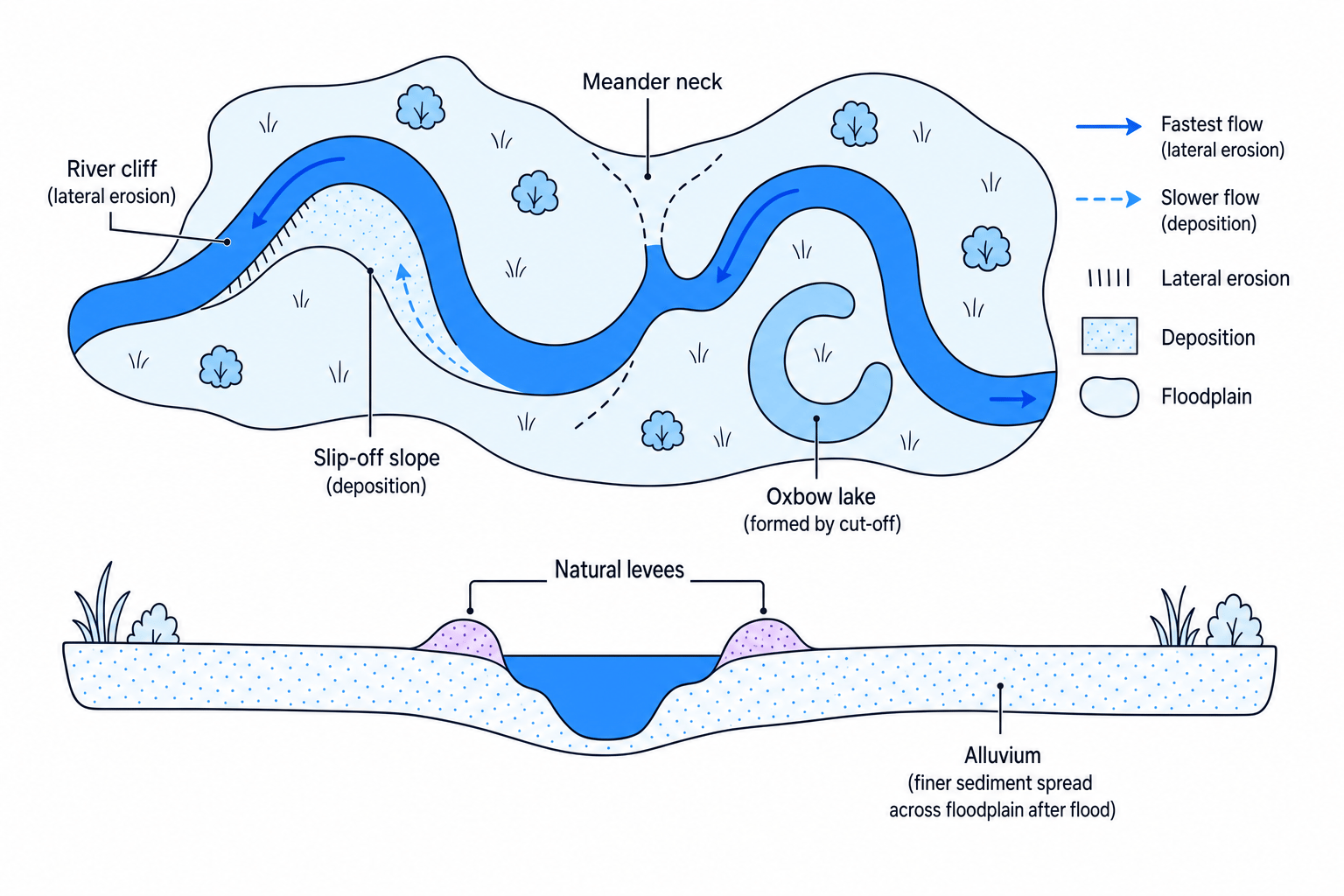
A meander is a large bend in a river. On the outside of a bend, water is deeper and faster, so lateral erosion forms a steep river cliff. On the inside of a bend, water is shallower and slower, so deposition forms a gentle slip-off slope.
Over time, meanders migrate across the valley floor, helping to widen the floodplain.
Oxbow lakes
An oxbow lake is a curved lake formed when a meander is cut off from the main river. Lateral erosion narrows the meander neck. During high discharge, the river may cut straight through the neck. Deposition then seals the old bend, leaving a separate lake.
Floodplains and levees
A floodplain is the wide, flat valley floor beside a river, built by lateral erosion and deposition. Alluvium means river-deposited sediment. When a river floods, water spreads over the floodplain and loses velocity, so it deposits alluvium.
Levees are raised natural banks beside the river channel. They form because heavier sediment is deposited first, close to the channel, while finer sediment is carried further across the floodplain.
Use process chains
For landform questions, write in chains: process → effect → landform. For example: faster flow on the outside bend → lateral erosion → river cliff and widening meander.
The big downstream pattern
From source to mouth, the river changes from a steep, narrow, erosion-dominated upland system to a wider, deeper, deposition-influenced lowland system. The key reason is that gradient, discharge, sediment load and channel efficiency all change downstream.
This does not mean erosion stops in the lower course or deposition never happens upstream. It means the dominant processes change.
In the exam
-
Name the process precisely: vertical erosion, lateral erosion, transportation, deposition, weathering or mass movement.
-
Link the process to a feature of the river, such as steep gradient, high discharge, resistant geology or slower velocity.
-
Use a named river where asked. For this topic, the River Tees works well: Pennine source, High Force waterfall, wider lower course towards Teesside.
-
For formation questions, use a clear sequence rather than a description of the final landform only.
Check yourself
- Why does vertical erosion dominate in the upper course of a river?
- How do width, depth, discharge and sediment shape usually change downstream?
- Explain how a meander can eventually become an oxbow lake.
