

What you'll learn
- How waves, weathering and mass movement shape coastal environments.
- How geology, vegetation, people and sea-level change influence what a coast looks like.
- How erosional landforms such as headlands, bays, cliffs and stacks form.
- How depositional landforms such as beaches, spits and bars develop.
1. The coast as a dynamic environment
A coast is the zone where the land meets the sea. It is constantly changing because energy and sediment are moving through the system.
Coastal processes
Coastal processes are the actions that shape the coastline. They include marine processes from the sea, weathering on exposed rock, and mass movement down slopes under gravity.
A useful way to think about coasts is as a sediment system. Sediment can enter from cliff erosion, rivers and offshore sources; it can move along the coast; and it can be stored in beaches, spits and dunes.
The big picture
Coastal landforms are not random: they form because different processes act on different materials with different levels of resistance.
2. Waves: the main source of marine energy
Most coastal erosion and deposition begins with waves. Waves are created when wind blows over the sea surface.
Fetch
Fetch is the distance of open water over which wind blows. A longer fetch usually allows waves to become larger and more powerful.
Wave energy depends mainly on:
- wind speed
- how long the wind blows for
- fetch
- the depth and shape of the seabed near the coast
Swash and backwash
When a wave breaks on the beach, water runs up the beach as swash. Water then drains back down the beach under gravity as backwash.
Constructive and destructive waves
Constructive waves have stronger swash than backwash, so they tend to build beaches. Destructive waves have stronger backwash than swash, so they tend to remove sediment from beaches.
Constructive waves are usually lower and less frequent. Destructive waves are usually steeper, more powerful and more frequent, especially during storms.
3. Marine erosion, transportation and deposition
Marine erosion
Erosion means the wearing away and removal of material. On coasts, the sea erodes cliffs and shore platforms in several ways.
Types of marine erosion
- Hydraulic action: waves force air and water into cracks, increasing pressure until rock breaks apart.
- Abrasion: waves throw sand, pebbles and boulders against the cliff, scraping it like sandpaper.
- Attrition: rock fragments carried by the sea knock into each other, becoming smaller and rounder.
- Solution: some rocks, especially limestone and chalk, dissolve slowly in seawater.
Marine transportation
Transportation means the movement of sediment. Waves and currents can move material in several ways: rolling larger stones along the seabed, bouncing pebbles, carrying fine material in suspension, and carrying dissolved minerals in solution.
The most important coastal transportation process for this topic is longshore drift.
Longshore drift
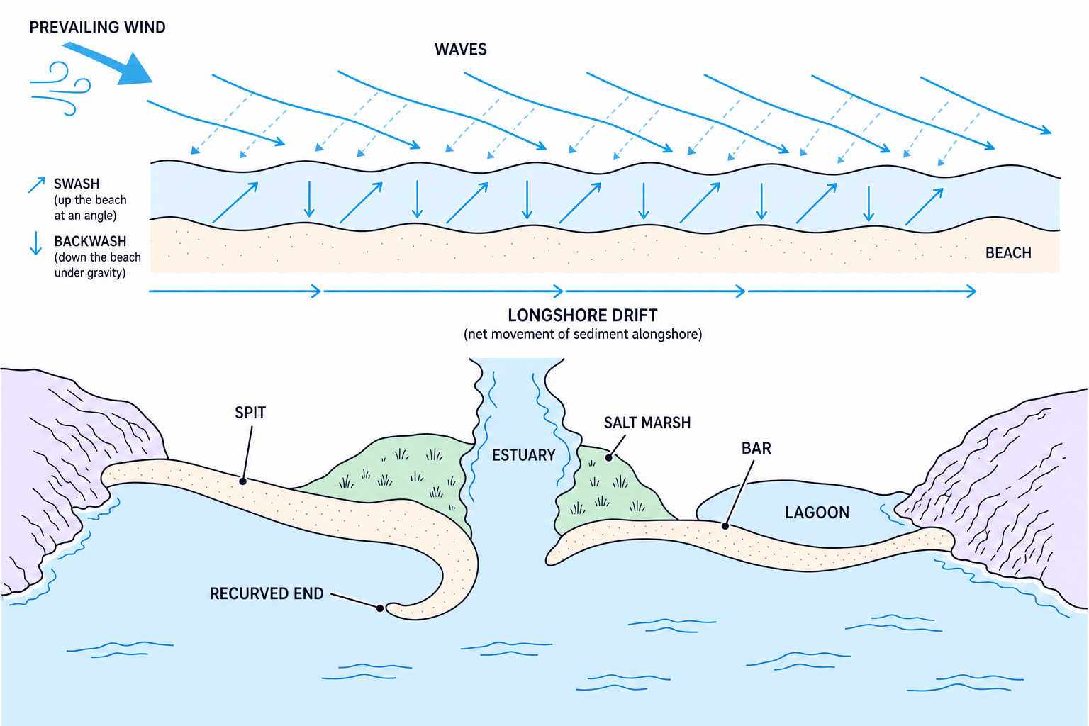
Longshore drift is the net movement of sediment along a beach when waves approach the coast at an angle.
Swash carries sediment diagonally up the beach in the direction of the prevailing wind. Backwash then moves sediment straight down the beach under gravity. Over time, sediment zig-zags along the coastline.
Longshore drift
Longshore drift is mainly the movement of sediment, not the whole sea moving sideways along the coast.
Marine deposition
Deposition happens when the sea loses energy and drops the sediment it is carrying. This often occurs in sheltered areas such as bays, behind spits, or where constructive waves dominate.
Working out the direction of longshore drift
- Identify the angle of wave approach: if waves arrive from the south-west, swash will move sediment diagonally up the beach towards the north-east.
- Apply gravity to the backwash: backwash runs straight down the beach, not back along the wave angle.
- Combine the two movements: the sediment follows a zig-zag path, so the net movement is along the coast towards the north-east.
4. Weathering and mass movement
Marine erosion acts at the base of cliffs, but other processes weaken cliffs from above and within.
Weathering
Weathering is the breakdown of rock in place, without the material being transported away.
There are three main types:
- Mechanical weathering: physical breakdown, such as freeze-thaw weathering or salt crystallisation.
- Chemical weathering: chemical changes, such as limestone dissolving in weakly acidic rainwater.
- Biological weathering: breakdown caused by living things, such as plant roots widening cracks.
Mass movement
Mass movement is the downhill movement of rock, soil or clay under gravity.
Two important types for Edexcel IGCSE are:
- Sliding: material moves downslope along a fairly straight slip plane.
- Slumping: saturated material, often clay, moves down a curved slip plane, leaving a rotated, stepped slope.
Slumping is common on soft, weak coasts after heavy rainfall because water adds weight and reduces friction. The Holderness Coast in eastern England is a good UK example, where soft glacial till is easily eroded and prone to slumping.
Erosion, weathering and mass movement
Do not use these terms as if they mean the same thing. Weathering breaks rock down in place, erosion removes material, and mass movement shifts material downslope under gravity.
5. What controls the shape of a coast?
Geology
Geology means the rock type and rock structure of an area. It strongly affects coastal landforms.
Rock resistance
A resistant rock is harder to erode, such as granite or chalk. A less resistant rock is eroded more quickly, such as clay or some sands.
A discordant coastline has bands of different rock types at right angles to the coast. Less resistant rock erodes quickly to form bays. More resistant rock remains sticking out as headlands.
A concordant coastline has rock bands running roughly parallel to the coast. It may have a resistant outer layer protecting weaker rock behind it, although weaknesses can still be breached.
Rock structure matters too. Joints, faults and bedding planes are weaknesses that waves can exploit, especially on headlands.
Vegetation
Vegetation can stabilise coastal environments. Plant roots bind sediment together, while grasses and salt-marsh plants trap sediment and reduce wind and water energy.
For example, marram grass helps stabilise sand dunes by trapping wind-blown sand. Salt marshes behind spits can also trap fine sediment in sheltered water.
People
People can change coastal processes through building, farming, tourism and coastal management.
Examples include:
- Sea walls, which reflect wave energy and protect cliffs locally.
- Groynes, which trap sediment moving by longshore drift and build up beaches.
- Rock armour, which absorbs wave energy.
- Beach nourishment, where sediment is added to maintain a beach.
Human intervention can protect one place but increase erosion somewhere else. At Mappleton on the Holderness Coast, rock groynes have helped protect the village, but they also reduce sediment moving southwards by longshore drift, which can worsen erosion downdrift.
Sea-level change
Relative sea-level change means sea level changes compared with the land. It can happen because global sea level rises or because land rises or sinks.
Rising sea level can:
- allow waves to attack higher up cliffs
- increase coastal flooding risk on low-lying land
- push beaches and salt marshes inland if space is available
- drown river valleys and create sheltered inlets
Global sea level has risen by roughly 20 cm since 1900, though local change varies. In the UK, parts of southern and eastern England are especially vulnerable because some land is slowly sinking.
Controls on coastal shape
The same wave energy can create different landforms depending on rock resistance, rock structure, sediment supply, vegetation, human intervention and sea-level change.
6. Erosional landforms
Headlands and bays
Headlands and bays form where rocks have different resistance to erosion. Less resistant rock is eroded faster, forming a bay. More resistant rock erodes slowly and is left protruding as a headland.
Waves are refracted around headlands. This concentrates wave energy on the headland, increasing erosion. Bays are more sheltered, so wave energy is lower and deposition is more likely.
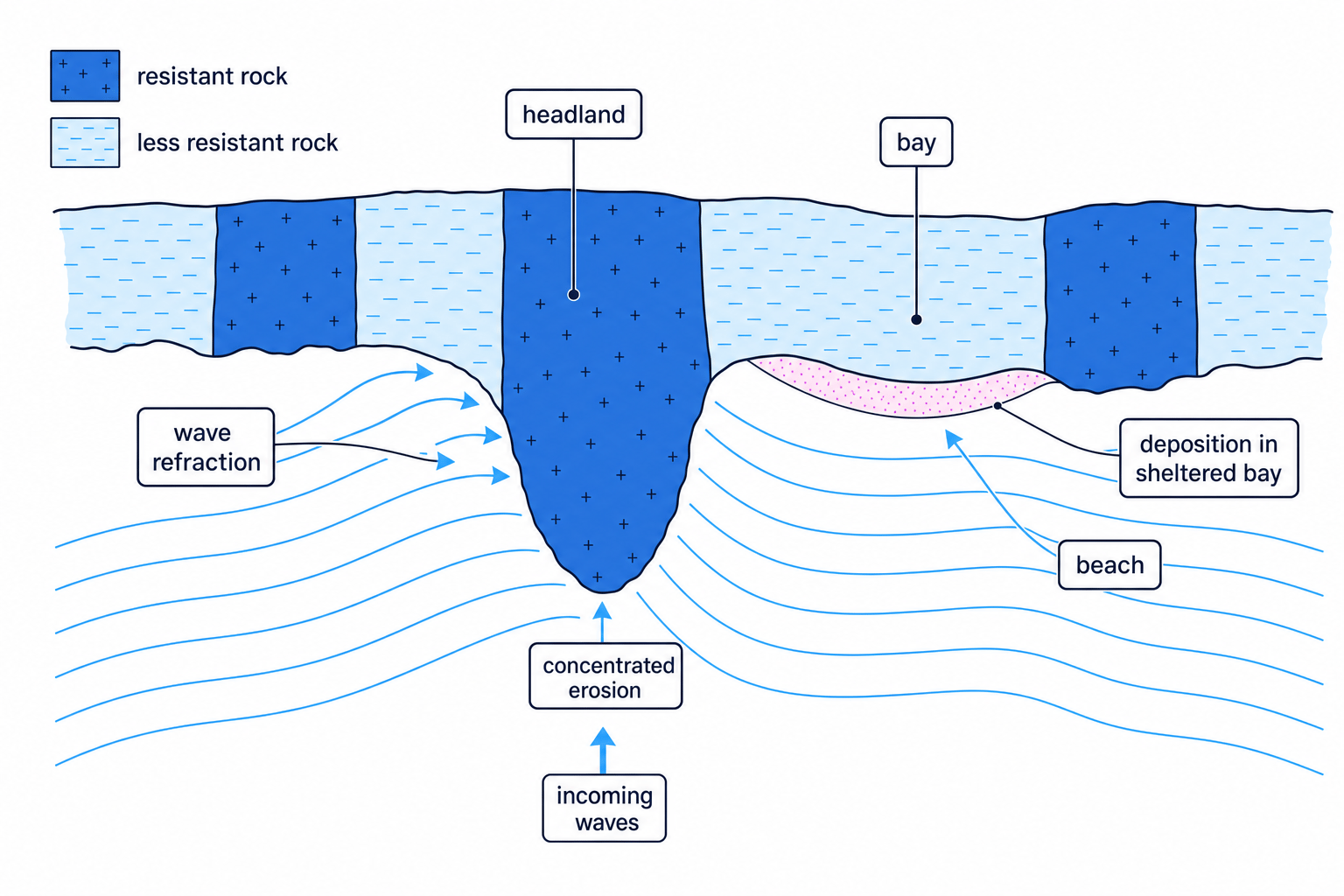
Good UK located examples include the Dorset coast, where harder limestone and chalk form headlands while softer clays and sands are eroded into bays. Old Harry Rocks and Studland Bay are useful named examples from the Jurassic Coast area.
Predicting headlands and bays from geology
- Compare rock resistance: if clay lies next to limestone, the clay will usually erode faster than the limestone.
- Link erosion to shape: the clay area retreats inland to form a bay, while the limestone remains as a protruding headland.
- Add wave energy: wave refraction focuses erosion on the headland, while the bay becomes more sheltered and may develop a beach.
Cliffs and wave-cut platforms
A cliff is a steep rock face along the coast. Cliffs often form where destructive waves attack the base of a slope.
The process is:
- Waves erode the base of the cliff by hydraulic action and abrasion.
- A wave-cut notch forms at the cliff foot.
- The notch deepens, leaving an overhang.
- The overhang collapses due to gravity.
- The cliff retreats inland.
- A gently sloping wave-cut platform is left behind, often visible at low tide.
Wave-cut platform
A wave-cut platform is a gently sloping rocky surface at the base of a retreating cliff, created by repeated erosion and cliff collapse.
Caves, arches, stacks and stumps
On headlands, waves exploit weaknesses such as joints and faults.
The sequence is:
- A crack is widened into a cave.
- Caves may erode through a headland to form an arch.
- The arch roof collapses, leaving an isolated pillar called a stack.
- The stack is eroded down into a lower stump.
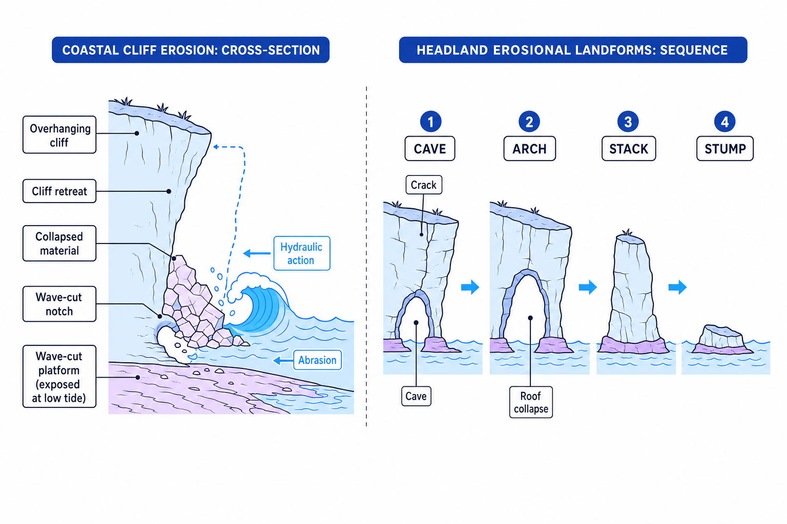
Old Harry Rocks in Dorset is a classic UK example of chalk stacks. The landforms show how marine erosion, weathering and mass movement work together over time.
Explaining the cave-to-stump sequence
- Start with a weakness: waves attack a joint or fault in the headland using hydraulic action and abrasion.
- Extend the weakness: the crack widens into a cave, and continued erosion may cut through the headland to form an arch.
- Add collapse and continued erosion: weathering weakens the arch roof, it collapses into a stack, and further erosion reduces the stack to a stump.
7. Depositional landforms
Beaches
A beach is an accumulation of sand, shingle or pebbles between the high and low tide marks. Beaches form where deposition is greater than erosion.
Constructive waves help build beaches because strong swash pushes sediment up the beach, while weaker backwash removes less material.
Beach material affects beach shape:
- Sand beaches are usually wider and gently sloping.
- Shingle beaches are usually steeper because water drains quickly through the gaps, weakening backwash.
Spits
A spit is a narrow ridge of sand or shingle joined to the land at one end and extending out into the sea or across an estuary.
Spits form when longshore drift moves sediment along the coast and the coastline suddenly changes direction, such as at a river mouth. Sediment continues to be deposited into the open water. The end may become curved due to changing wind and wave direction.
Sheltered water behind a spit allows fine mud to settle, often forming salt marsh. Spurn Head on the Holderness Coast and Hurst Spit in Hampshire are useful UK examples.
Bars
A bar forms when a spit grows across a bay, joining two headlands. Water trapped behind the bar can form a lagoon.
Chesil Beach in Dorset is often used as a major UK depositional example, although its exact formation is more complex than a simple spit-to-bar model.
Explaining spit formation from a map
- Identify the sediment movement: if longshore drift moves eastwards, beach material is transported along the coast in that direction.
- Find the break in the coastline: at an estuary, waves lose energy and cannot carry all the sediment further, so deposition begins.
- Build the landform: sediment accumulates out from the coast as a spit, while river flow prevents it completely blocking the estuary.
- Add detail for development: changing wind or wave direction may curve the end, and sheltered water behind the spit can develop into salt marsh.
A strong landform explanation
For landform formation questions, use the chain: process → action → result → named landform. For example: “Longshore drift transports sediment along the coast; where the coastline changes direction, energy falls and deposition forms a spit.”
8. Bringing the processes together
Most coastal landforms are not produced by one process alone. A cliff, for example, may be shaped by:
- destructive waves eroding the base
- chemical and mechanical weathering weakening the face
- slumping after heavy rainfall
- human defences changing wave energy or sediment supply
- sea-level rise allowing waves to reach higher areas
This is why Edexcel questions often ask you to “explain” rather than just “describe”. You need to connect the process to the landform.
In the exam
- Name the landform and the key process early: for example, “A spit forms mainly by longshore drift and deposition.”
- Build a sequence using connectives such as “because”, “therefore” and “over time” so the examiner can see cause and effect.
- Use precise terms: swash, backwash, hydraulic action, abrasion, deposition, resistant rock, slumping and wave-cut platform.
- Add a located example where possible, such as Holderness, Dorset’s Jurassic Coast, Old Harry Rocks, Spurn Head or Hurst Spit.
- For diagrams or photos, use the evidence shown: rock bands, cracks, beach direction, cliff collapse or a river mouth.
Check yourself
- How does longshore drift move sediment along a beach?
- Why do headlands and bays form on some discordant coastlines?
- What is the sequence from wave-cut notch to wave-cut platform?
