What you'll learn
- Why the global hydrological cycle is described as a closed system.
- The main stores and transfers of water.
- The key features of a drainage basin, including the source, watershed, channel network and mouth.
- How precipitation, temperature, vegetation, land use, water abstraction and dams affect river regimes and storm hydrographs.
1. The hydrological cycle as a closed system
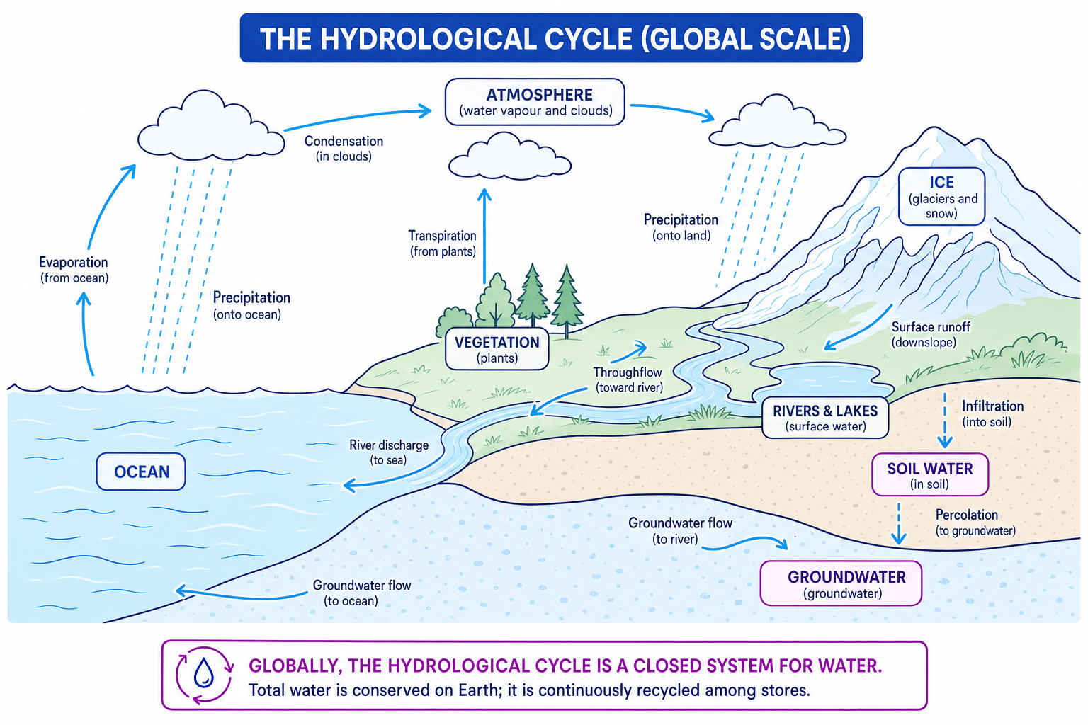
The hydrological cycle is the continuous movement of water between the land, oceans, atmosphere and living things. At a global scale, Earth’s water is recycled again and again: water changes location and state — for example from liquid water to water vapour — but the total amount of water stays almost the same.
Closed system
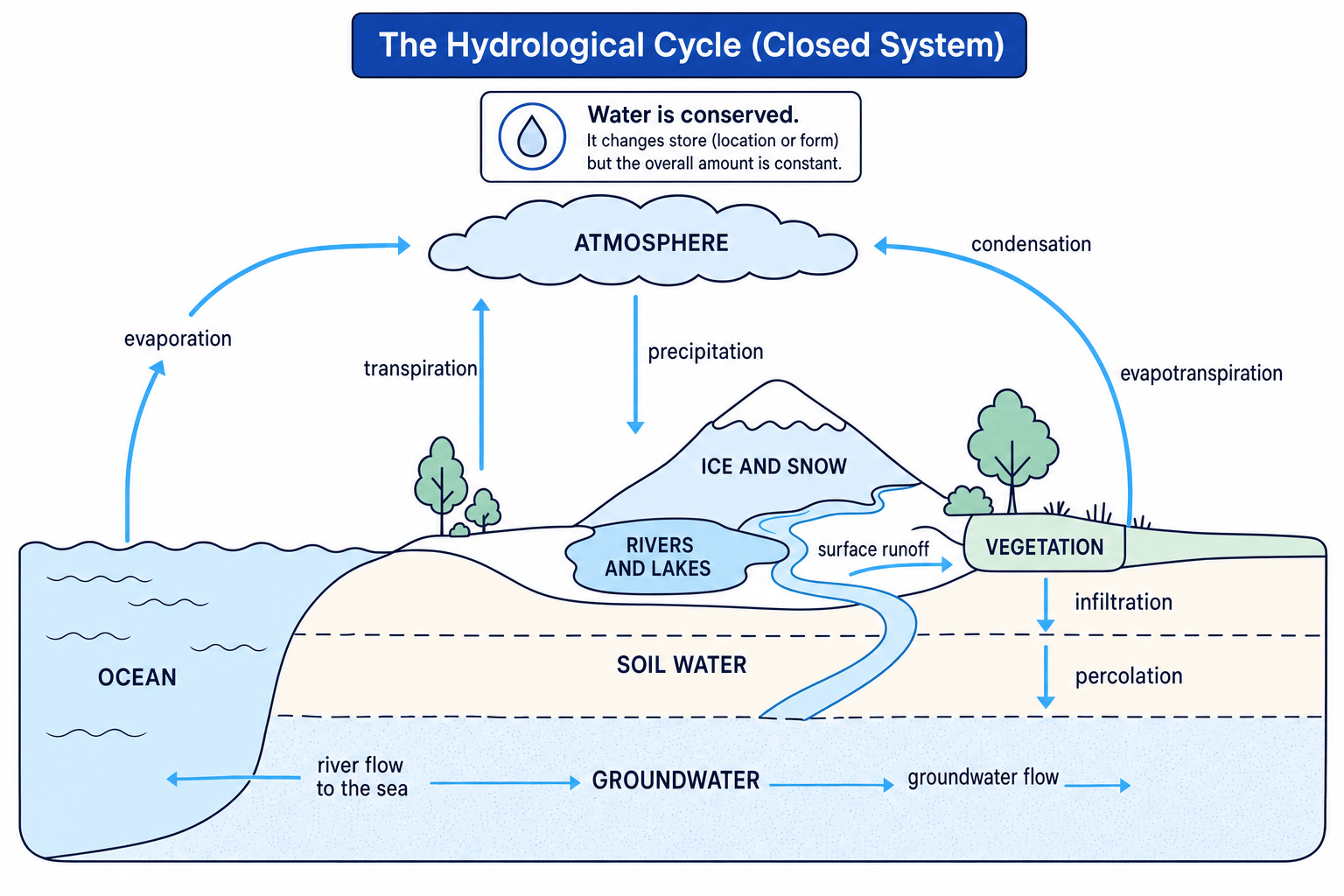
A closed system has no significant input or output of matter. In the global hydrological cycle, water is not usually added to or removed from Earth in meaningful amounts, although energy from the Sun drives the cycle.
At IGCSE level, the key idea is simple: the world’s water supply is finite. The same water is constantly moved, stored and recycled.
Closed does not mean still
A closed system can still have lots of movement inside it. Water is constantly transferred between oceans, air, rivers, ice, soil and groundwater — it is just not significantly entering or leaving Earth overall.
2. Stores: where water is held
A store is a place where water is held for a period of time. Some stores hold water for days or weeks; others hold it for thousands of years.
Water store
A water store is any part of the hydrological cycle where water is held, such as the ocean, atmosphere, ice, groundwater, soil, rivers, lakes or vegetation.
Main global water stores
- Oceans: the largest store, containing about 97% of Earth’s water, mostly salty.
- Ice and snow: water stored in glaciers, ice sheets and snowfields.
- Groundwater: water stored underground in rocks and pores in soil.
- Soil water: water held in the soil, available to plants.
- Rivers and lakes: smaller surface stores, but very important for people and ecosystems.
- Atmosphere: water vapour, droplets and ice crystals in the air.
- Vegetation: water stored in plants.
The big picture
Most of Earth’s water is in the oceans, while only a very small proportion is fresh, liquid and easily available for human use.
3. Transfers: how water moves between stores
A transfer is a movement of water from one store to another. Transfers are the “arrows” in the hydrological cycle.
Water transfer
A water transfer is a process that moves water between stores, such as evaporation, precipitation, infiltration, surface runoff or river flow.
Key transfers you need to know
- Evaporation: liquid water changes into water vapour due to heat, especially from oceans, lakes and rivers.
- Transpiration: water vapour is released from plants through tiny openings in leaves.
- Evapotranspiration: the combined total of evaporation and transpiration.
- Condensation: water vapour cools and changes into tiny water droplets, forming clouds.
- Precipitation: water falls from the atmosphere as rain, snow, sleet or hail.
- Infiltration: water soaks from the ground surface into the soil.
- Percolation: water moves deeper through soil and rock into groundwater stores.
- Surface runoff: water flows over the land surface into streams and rivers.
- Throughflow: water moves sideways through the soil towards a river.
- Groundwater flow: water moves slowly through rocks underground.
- River discharge: water flows through a river channel towards the sea or a lake.
Tracing water through the cycle
-
A water droplet in the ocean is heated by the Sun, so it changes from liquid water into water vapour by evaporation.
-
The water vapour rises, cools and turns into cloud droplets by condensation, moving into the atmospheric store.
-
The droplet falls as precipitation onto a hillside, then either infiltrates into the soil, flows over the surface as runoff, or enters a river channel.
-
If it reaches a river, it is carried by river flow back towards the sea, completing one possible route through the hydrological cycle.
4. Drainage basins: the hydrological cycle at river scale
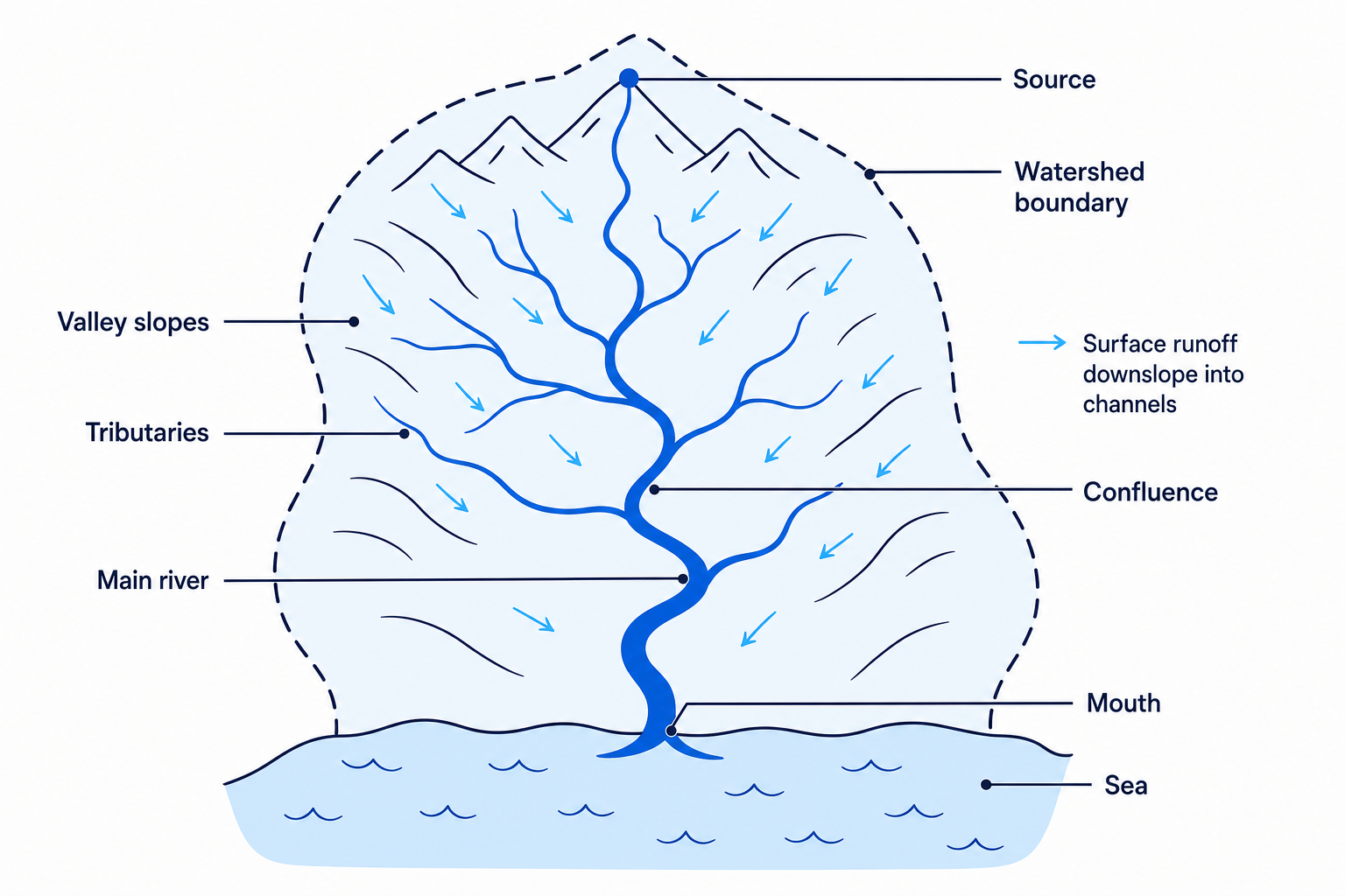
A drainage basin is the area of land drained by a river and its tributaries. You can think of it as the land area that “feeds” water into one river system.
Drainage basin
A drainage basin is an area of land drained by a river and its tributaries, separated from neighbouring basins by a watershed.
At the drainage basin scale, the system is usually treated as an open system. It has inputs, stores, transfers and outputs.
- Input: precipitation entering the basin.
- Stores: soil water, groundwater, lakes, vegetation and channel storage.
- Transfers: infiltration, overland flow, throughflow, groundwater flow and river flow.
- Outputs: river discharge leaving the basin at the mouth, plus evapotranspiration.
Key drainage basin features
- Source: the place where a river begins, often in upland areas.
- Watershed: the boundary between one drainage basin and another, usually along higher land.
- Channel network: the pattern of the main river and its tributaries.
- Tributary: a smaller stream or river that flows into a larger river.
- Confluence: the point where two rivers or streams meet.
- Mouth: the place where a river flows into the sea, a lake or a larger river.
A named example you may see in the UK is the River Severn, which rises in the Cambrian Mountains in Wales and flows through western England to the Bristol Channel. Its drainage basin includes tributaries, uplands, towns, farmland and floodplains — all of which affect how water reaches the river.
Source to mouth
A river usually starts at its source in higher land and ends at its mouth. The watershed is not the river edge — it is the outer boundary of the whole drainage basin.
5. River regimes: how discharge changes over time
A river regime is the seasonal pattern of a river’s discharge over a year. Discharge means the volume of water flowing past a point in a river each second, usually measured in cubic metres per second, written as m³/s.
River regime
A river regime is the typical pattern of river discharge across the year, influenced by climate, geology, vegetation, land use and human management.
For example, a river in a snowy mountain region may have high discharge in spring or summer when snow melts. A river in a tropical monsoon climate may have very high discharge during the wet season and much lower discharge during the dry season.
6. Storm hydrographs
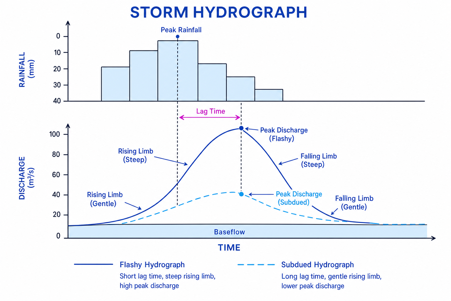
A storm hydrograph shows how a river’s discharge changes after a rainfall event. It helps you link rainfall to river response.
Storm hydrograph
A storm hydrograph is a graph showing rainfall and river discharge over time after a storm. It is used to judge how quickly and strongly a drainage basin responds to precipitation.
Key storm hydrograph terms
- Baseflow: the normal river flow before the storm, mainly supplied by groundwater.
- Rising limb: the part of the graph where discharge increases after rainfall.
- Peak discharge: the highest discharge reached.
- Lag time: the time between peak rainfall and peak discharge.
- Falling limb: the part of the graph where discharge decreases after the peak.
A flashy hydrograph has a steep rising limb, high peak discharge and short lag time. This means water reaches the river quickly, increasing flood risk.
A subdued hydrograph has a gentler rising limb, lower peak discharge and longer lag time. This means water reaches the river more slowly.
Interpreting lag time and flood risk
A storm hydrograph shows peak rainfall at 13:00 and peak discharge at 19:00. Baseflow is 20 m³/s and peak discharge is 95 m³/s.
-
Calculate the lag time by subtracting the time of peak rainfall from the time of peak discharge: 19:00 minus 13:00 gives 6 hours.
-
Compare peak discharge with baseflow: discharge rises from 20 m³/s to 95 m³/s, an increase of 75 m³/s.
-
Use both results together: a 6-hour lag time with a large discharge rise suggests the basin responds fairly quickly, so flood risk may be significant, especially if the rising limb is steep.
7. Factors affecting river regimes and hydrographs
Different drainage basins respond differently to rainfall. The same storm can cause a rapid flood in one basin but a slower, smaller rise in another.
Precipitation
Precipitation is one of the strongest controls on river flow.
- Heavy rainfall increases surface runoff and raises discharge.
- Long-duration rainfall can saturate the soil, reducing infiltration and increasing overland flow.
- Snowfall may be stored as snow or ice, delaying river flow until temperatures rise.
In areas with intense rainfall, such as parts of Bangladesh during the monsoon season, rivers can rise rapidly. In contrast, rivers in dry climates may have very low discharge for long periods.
Temperature
Temperature affects how much water is lost through evapotranspiration and whether precipitation is stored as snow or ice.
- Higher temperatures usually increase evaporation and transpiration, reducing river discharge.
- In cold areas, water may be stored as snow and ice, lowering winter discharge.
- When snow melts in spring or summer, discharge can rise sharply.
Vegetation
Vegetation can slow water down before it reaches the river.
- Leaves and branches cause interception, where rainfall is temporarily stored on vegetation surfaces.
- Roots help create spaces in the soil, increasing infiltration.
- Plants return water to the atmosphere through transpiration.
Forested basins often have longer lag times and lower peak discharge than deforested basins, if other factors are similar.
Land use
Land use means how people use the land, such as farming, forestry, housing, roads or industry.
- Urban areas have impermeable surfaces like concrete and tarmac, so infiltration is reduced.
- Drains and gutters move water quickly into rivers, shortening lag time.
- Compacted farmland can reduce infiltration and increase surface runoff.
- Bare soil after vegetation clearance is more exposed to erosion and rapid runoff.
Urbanisation affects both speed and amount
Do not just say urbanisation “causes flooding”. Explain the process: impermeable surfaces reduce infiltration, drains speed up transfer to the channel, lag time shortens and peak discharge rises.
Water abstraction
Water abstraction means taking water from rivers, lakes or groundwater for human use, such as drinking water, irrigation or industry.
Abstraction can reduce river discharge, especially during dry seasons. For example, heavy water use in the Colorado River basin in the USA and Mexico has reduced flows downstream; in some years, very little water reaches the Gulf of California. Exact figures vary by year and management decisions.
Dams and reservoirs
A dam is a barrier built across a river to store or control water. The reservoir behind it stores water that can be used for water supply, irrigation, flood control or hydroelectric power.
Dams often reduce peak discharge downstream because storm water is stored and released more slowly. They can also increase dry-season flows if water is released from the reservoir. A well-known example is the Aswan High Dam on the River Nile in Egypt, which has helped control seasonal flooding and provide water for irrigation, while also changing sediment movement and downstream ecosystems.
Controls on river response
A river regime is shaped by both natural factors, such as precipitation, temperature and vegetation, and human factors, such as land use, abstraction and dams.
In the exam
-
When describing a hydrograph, use precise terms: peak discharge, lag time, rising limb, falling limb and baseflow.
-
When explaining a factor, link cause to process to result: for example, “urban surfaces reduce infiltration, so more water becomes surface runoff, which shortens lag time and raises peak discharge.”
-
If you use a named example, keep it relevant and located: for example, River Severn in the UK, Colorado River in the USA/Mexico, or River Nile in Egypt.
Check yourself
- Why is the global hydrological cycle described as a closed system, but a drainage basin often described as an open system?
- What is the difference between infiltration, percolation and surface runoff?
- How would deforestation or urbanisation change the shape of a storm hydrograph?