What you'll learn
- Why earthquake impacts depend on risk, not just magnitude.
- How preparation reduces deaths and damage before an earthquake happens.
- What short-term responses do in the first hours and days after a disaster.
- How longer-term planning helps communities rebuild more safely, using Japan and Nepal as case studies.
The big idea: earthquakes cannot be stopped, but risk can be reduced
An earthquake is a sudden shaking of the ground caused by energy being released in the Earth’s crust, usually along a fault — a fracture where rocks move past each other. Earthquakes become a serious hazard when they threaten people, buildings and infrastructure.
A large earthquake in an empty desert may cause little damage. A smaller earthquake beneath a crowded city with weak buildings can be disastrous. So, geographers focus on risk.
Key terms
- Risk means the chance of people or property being harmed by a hazard.
- Exposure means how many people, buildings and services are in the hazard zone.
- Vulnerability means how easily people or places are damaged.
- Capacity means the ability to prepare, respond and recover.
- Resilience means the ability to cope with and recover from a hazard.
Risk, not just magnitude
Earthquake management aims to reduce risk by lowering vulnerability, improving capacity and planning for exposed places.
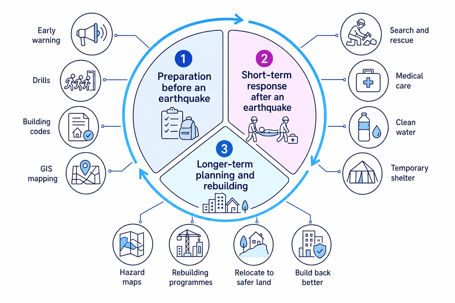
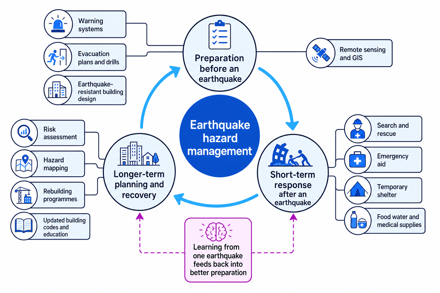
Earthquake management is a cycle: prepare before the event, respond quickly afterwards, then rebuild and plan better for the next one.
1. Preparation before an earthquake
Preparation means actions taken before an earthquake to reduce deaths, injuries and damage. It includes warning systems, evacuation planning, building design, remote sensing and GIS.
Warning and evacuation
An earthquake warning system detects the first, less damaging P-waves and sends alerts before the stronger shaking arrives. This may give only a few seconds to tens of seconds, but that can still allow trains to stop, gas supplies to shut off and people to “drop, cover and hold on”.
Evacuation means moving people away from danger. For earthquakes, this often means practising safe behaviour during shaking and evacuating unsafe buildings afterwards. If the earthquake is offshore, evacuation may also mean moving quickly to higher ground because of a possible tsunami — a series of large sea waves triggered by sudden movement of the seabed.
Warning is not prediction
A warning system does not predict earthquakes days in advance. It detects an earthquake after it has started and sends an alert before the strongest shaking reaches some places.
Remote sensing and GIS
Remote sensing means collecting information from a distance, for example using satellites, aircraft or drones. Before an earthquake, it can help identify fault lines, unstable slopes and dense urban areas.
GIS stands for Geographical Information Systems. It is computer software used to store, layer and analyse map data. GIS can combine data on population density, building age, roads, hospitals, fault lines and landslide risk to show where preparation should be focused.
Earthquake-resistant building design
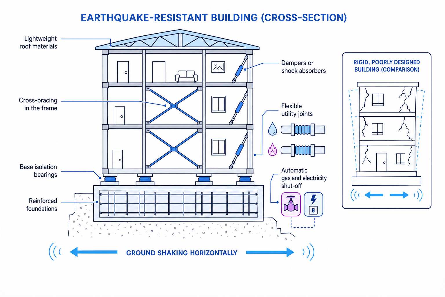
Earthquake-resistant buildings are designed to bend, sway or absorb energy rather than collapse. Common features include base isolation, cross-bracing, shock absorbers, reinforced foundations and flexible gas, water and electricity pipes.
A better phrase than earthquake-proof
Use earthquake-resistant, not “earthquake-proof”. Very strong earthquakes can still damage buildings, but good design makes collapse less likely.
Prioritising preparation in a coastal city
A city is near an active fault, has old brick housing, several schools and a low-lying coast.
- Identify the main risks: shaking could collapse old brick buildings, while an offshore earthquake could also create tsunami risk for coastal districts.
- Match preparation to risk: strengthen schools and hospitals first, enforce building codes for new housing, and mark tsunami evacuation routes to higher ground.
- Justify the priority: schools and hospitals contain vulnerable people and are essential after a disaster, so protecting them reduces both deaths and recovery problems.
2. Short-term responses and relief
Short-term responses are actions taken immediately after an earthquake, usually in the first hours, days and weeks. Their aim is to save lives and reduce suffering.
Relief means emergency help such as search and rescue, medical care, temporary shelter, clean water, food, blankets and sanitation. The first 72 hours are especially important because trapped survivors are more likely to be found alive during this period.
A strong short-term response needs:
- Emergency aid: medical teams, rescue equipment, water purification, food and tents.
- Shelter: safe temporary housing in schools, sports halls, camps or community centres.
- Supplies: clean water, food, medicines, blankets, toilets and fuel.
- Coordination: local government, national agencies, charities and international organisations working together.
Choosing urgent relief priorities
A mountain village has collapsed houses, blocked roads and no clean water after an earthquake.
- Deal with life-threatening needs first: search and rescue, first aid and evacuation of badly injured people are the top priorities.
- Reduce secondary hazards: provide clean water and sanitation to prevent disease, especially if pipes and toilets have been damaged.
- Adapt to access problems: if roads are blocked by landslides, helicopters, drones or local footpaths may be needed to deliver supplies.
3. Longer-term planning
Longer-term planning happens after the emergency phase and can last months or years. It aims to reduce future risk, not just repair damage.
A risk assessment estimates where losses are most likely by considering hazard, exposure, vulnerability and capacity. A hazard map shows where hazards are more likely or more severe, such as strong shaking, landslides, liquefaction or tsunami flooding. Liquefaction happens when waterlogged sediment loses strength during shaking and behaves more like a liquid.
Rebuilding programmes repair and replace homes, schools, hospitals, roads and services. The best programmes aim to build back better, meaning reconstruction is safer than what existed before.
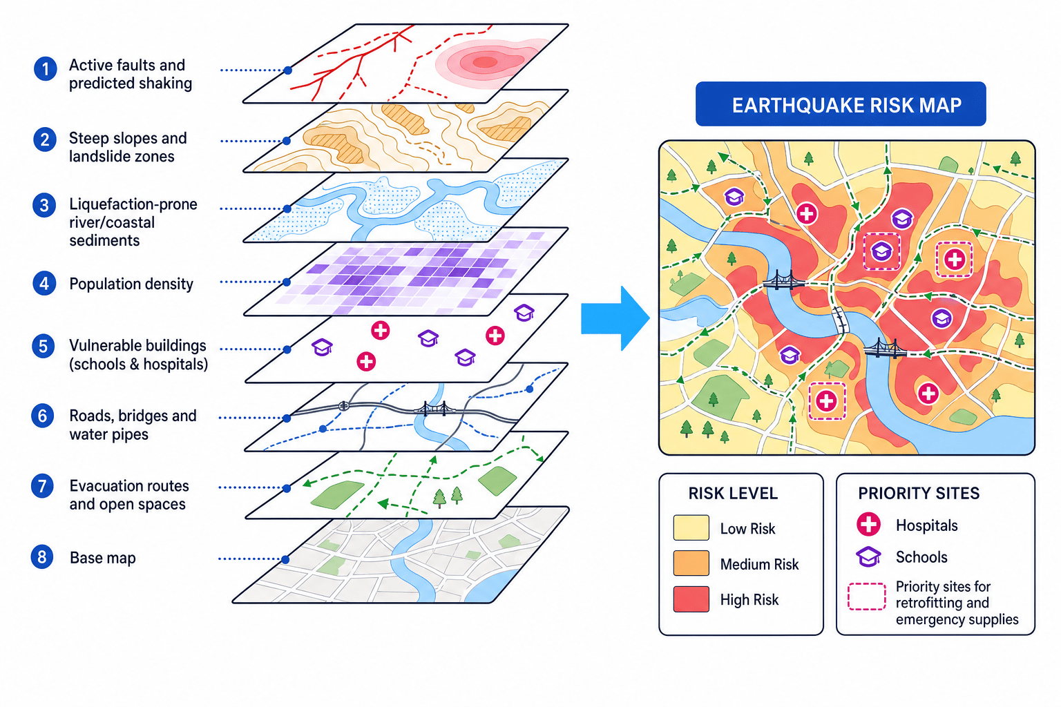
GIS is very useful here because it can combine many layers of evidence into one risk map.
Using GIS layers to plan rebuilding
A council wants to decide where to rebuild homes after an earthquake.
- Overlay hazard layers: faults, predicted shaking, landslide zones and liquefaction-prone river sediments show where physical danger is highest.
- Add exposure and vulnerability layers: population density, schools, hospitals, old buildings, roads and bridges show where damage would affect most people.
- Choose safer planning actions: avoid rebuilding on the highest-risk land, retrofit important buildings, widen evacuation routes and store emergency supplies near vulnerable communities.
🌐 Case studies: developed and developing country earthquake management
For Edexcel IGCSE, you need contrasting case studies of earthquake hazard management in a developed country and a developing or emerging country. A developed country usually has higher income, stronger infrastructure and greater government capacity. A developing country often has lower income and more limited resources, though this varies within countries.
Developed country: Japan — Tohoku earthquake, 2011
Japan is a high-income developed country on the Pacific Ring of Fire, where several tectonic plates meet. It has frequent earthquakes, strict building codes and advanced monitoring.
In March 2011, a magnitude 9.0 earthquake struck offshore from north-east Honshu. It triggered a devastating tsunami. About 16,000 people died, over 450,000 were displaced at the peak, and the Fukushima nuclear disaster added a major technological hazard.
Preparation: Japan had earthquake early warning alerts, tsunami warning systems, regular drills, hazard maps and strict seismic building codes. Many buildings survived the shaking well.
Short-term response: The Self-Defence Forces, firefighters, medical teams and coastguard carried out search and rescue. Evacuation centres in schools and public buildings provided shelter, food, water and medical support.
Longer-term planning: Japan created major rebuilding programmes, improved tsunami defences in some areas, relocated some communities to higher ground and updated hazard mapping. However, the tsunami exceeded some previous planning assumptions, showing that even rich countries remain vulnerable.
Developing country: Nepal — Gorkha earthquake, 2015
Nepal is a lower-income developing country in the Himalayas, between India and China. It has steep mountains, remote rural settlements and many buildings made from brick, stone or mud mortar, which are vulnerable to shaking.
In April 2015, a magnitude 7.8 earthquake struck near Gorkha, affecting Kathmandu and many mountain districts. Around 9,000 people died, about 22,000 were injured and millions were affected. Landslides and avalanches made access harder.
Preparation: Nepal had some community awareness, school safety projects and building codes, but enforcement was limited by poverty, rapid urban growth and remote terrain.
Short-term response: The Nepalese army, police, local communities and international teams provided search and rescue, emergency medical care, tents, tarpaulins, food and water. Aid delivery was difficult because roads were blocked, villages were isolated and the monsoon season was approaching.
Longer-term planning: The National Reconstruction Authority supported rebuilding of homes, schools, health posts and heritage sites. “Build back better” was promoted, but progress was slowed by bureaucracy, shortages of skilled labour and the challenge of reaching remote mountain communities.
Why the impacts differed
Japan’s stronger preparation reduced deaths from building collapse, but the tsunami caused extreme damage. Nepal’s lower capacity, weaker buildings and difficult relief access increased vulnerability, even though the earthquake magnitude was lower.
In the exam
- Structure management answers by time: preparation before, short-term response after, then longer-term planning and rebuilding.
- Use named evidence: for example, Japan 2011 as a developed country and Nepal 2015 as a developing country.
- Explain effectiveness, not just actions: link each strategy to reduced deaths, reduced damage or faster recovery.
Check yourself
- Why is earthquake risk not determined by magnitude alone?
- How do remote sensing and GIS help with preparation and longer-term planning?
- What are two reasons Nepal found emergency relief harder than Japan?