What you'll learn
- How to describe distribution — where features are found — for higher, steeper uplands and lower, gentler lowlands across the United Kingdom (UK).
- How past ice created glaciated landscapes — landscapes shaped by glaciers and ice sheets.
- How geology — rock type and structure — and climate — long-term weather patterns — help explain landscape differences.
- How human activity — the ways people use land — varies between upland, lowland and glaciated areas.
1. The starting point: what is a landscape?
A physical landscape is the visible shape and character of the land, including hills, valleys, rivers, rocks, soils and landforms. In GCSE Geography, you also consider how people use that land, because farming, settlement, tourism and transport often respond to the physical setting.
Core vocabulary
- Relief means the height and shape of the land, including altitude, slope steepness and whether the land is flat, rolling or mountainous.
- Altitude means height above sea level.
- Geology means the rocks beneath the surface, including their type, age, hardness and structure.
- Climate means the average weather conditions of a place over a long period, usually at least 30 years.
- Human activity means how people use and change the land, such as farming, building settlements, tourism, forestry and transport.
A useful way to think about this topic is: rocks help make the shape of the land, climate affects water and vegetation, and people use the land in ways that fit the opportunities and limits of that landscape.
2. The big UK pattern: north and west versus south and east
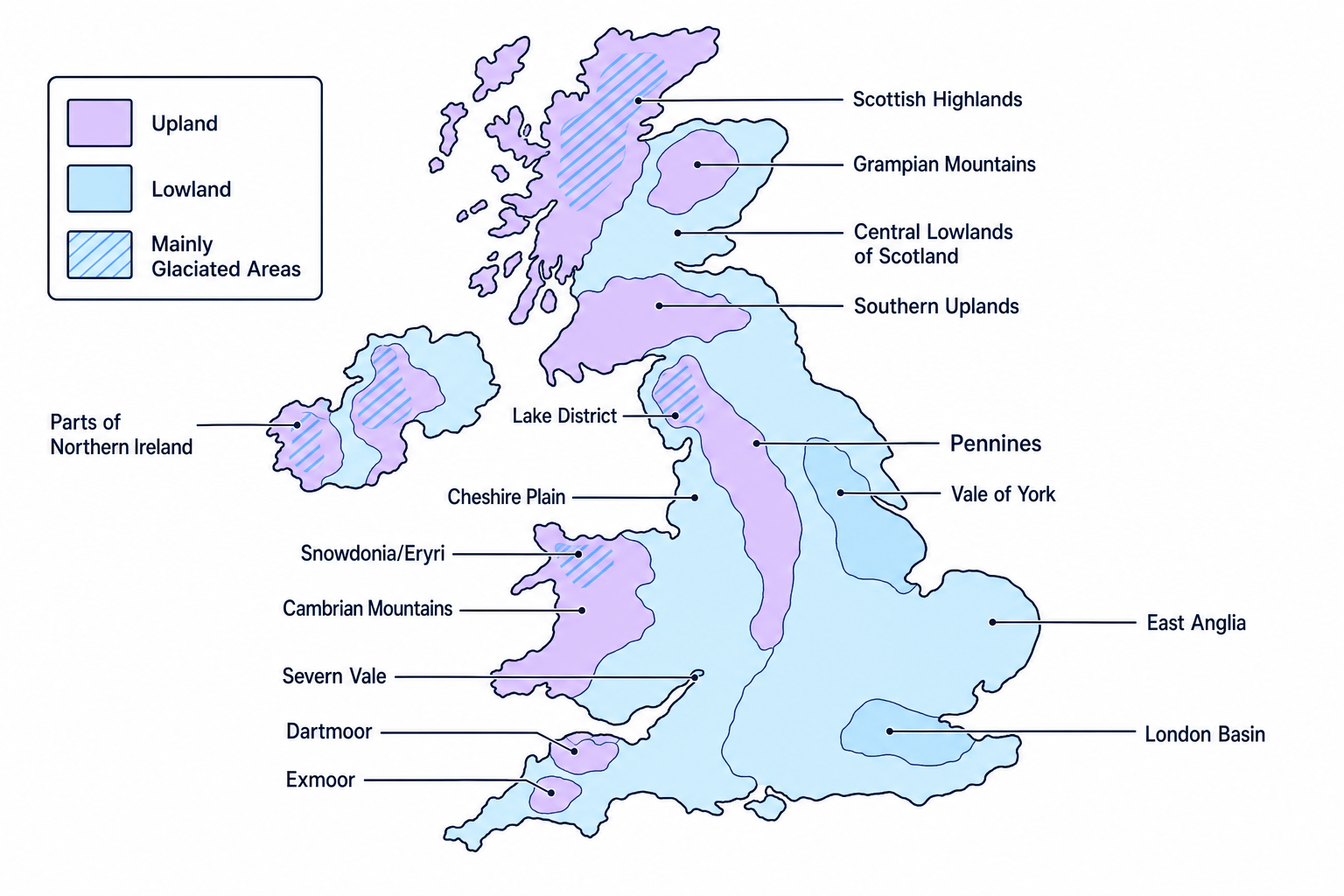
At a national scale, the UK has a clear pattern. The main upland and formerly glaciated landscapes are mostly in the north and west, while the main lowland landscapes are mostly in the south and east. The map below shows this simplified overview.
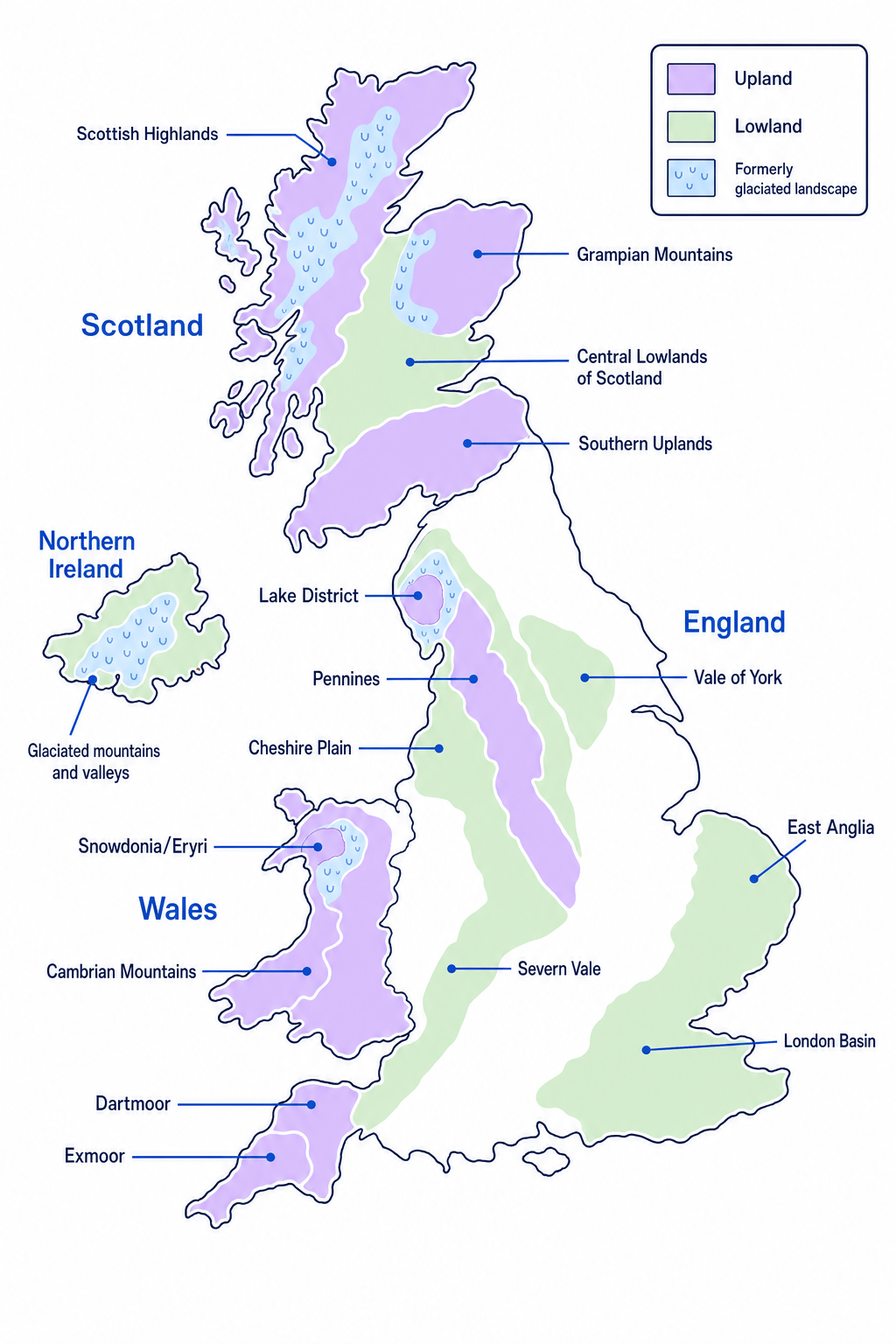
The national pattern
The UK’s higher, wetter, more rugged landscapes are mainly in the north and west; its lower, drier, more intensively farmed and urbanised landscapes are mainly in the south and east.
This pattern is not random. It reflects the UK’s geological history, its position next to the Atlantic Ocean, and the effects of the last ice age.
Worked example: describing a national distribution
Describing the distribution of UK uplands
- Start with the overall pattern: UK uplands are mainly found in the north and west of the country, rather than being evenly spread.
- Add named evidence: examples include the Scottish Highlands, Lake District, Pennines, Snowdonia/Eryri, Cambrian Mountains, Dartmoor and Exmoor.
- Add a contrast: many lowland areas are found in the south and east, such as East Anglia, the London Basin and the Vale of York.
- Make the description precise: mention that some uplands also occur in south-west England, so the pattern is “mainly” north and west, not “only” north and west.
3. Upland landscapes
Upland landscapes are areas of higher altitude, often with steep slopes, thin soils and exposed conditions. There is no single height that makes somewhere an upland; the key idea is that uplands are higher and more rugged than the surrounding lowlands.
Important UK upland areas include the Scottish Highlands, Grampian Mountains, Southern Uplands, Lake District, Pennines, Snowdonia/Eryri, Cambrian Mountains, Dartmoor and Exmoor.
Geology of uplands
Many UK uplands are made of older, harder rocks, including igneous rocks and metamorphic rocks. Igneous rocks form when molten rock cools and solidifies. Metamorphic rocks are rocks changed by heat and pressure. These rocks are often more resistant to erosion, so they can form high, rugged relief.
Some uplands also include hard sedimentary rocks, such as limestone or sandstone. Sedimentary rocks form from layers of material such as sand, mud, shells or organic matter that become compacted over time.
Climate of uplands
Uplands are generally cooler, wetter and windier than lowlands. Temperature falls with altitude, so higher places tend to be colder. Uplands in the west are especially wet because moist air arrives from the Atlantic Ocean.
The UK’s prevailing wind — the most common wind direction — is from the south-west. When this moist air is forced to rise over mountains, it cools, condenses and produces rain. This is called relief rainfall.
Explaining why western uplands are wet
- Moist air is carried towards the UK from the Atlantic by the prevailing south-westerly winds.
- When the air reaches uplands such as Snowdonia/Eryri, the Lake District or the Scottish Highlands, it is forced to rise over the higher land.
- Rising air cools, so water vapour condenses into clouds and rainfall.
- This means western uplands receive high rainfall, while areas further east can be drier in a rain shadow.
Human activity in uplands
Upland landscapes often have low population density, meaning fewer people live there per square kilometre. Farming is usually limited by steep slopes, thin soils and wetter conditions, so pastoral farming — farming animals rather than crops — is common. Sheep farming is especially important in upland Wales, northern England and Scotland.
Other common activities include:
- Tourism and recreation, such as walking, climbing and mountain biking in National Parks like the Lake District and Snowdonia/Eryri.
- Forestry, where conifer plantations are grown in wetter upland areas.
- Reservoirs, because uplands receive high rainfall and have valleys suitable for storing water.
- Quarrying, where valuable rock is extracted.
- Wind energy, because exposed uplands can be windy.
Thinking uplands are unused wilderness
Uplands may look remote, but they are not empty or untouched. They are working landscapes used for farming, water supply, forestry, tourism, conservation, energy and sometimes quarrying.
4. Lowland landscapes
Lowland landscapes are areas of lower altitude with gentler relief. They often have deeper soils, broader valleys and more accessible land, so they are usually more suitable for settlement, transport and intensive farming.
Major UK lowland areas include East Anglia, the London Basin, the Vale of York, the Cheshire Plain, the Severn Vale and the Central Lowlands of Scotland.
Geology of lowlands
Lowlands are often made from younger, softer sedimentary rocks such as clay, chalk, sandstone and limestone. Softer rocks are more easily eroded, which helps create gentler slopes and lower relief.
However, lowland does not always mean completely flat. Some lowland areas include rolling hills, scarps and gentle ridges, especially where more resistant rocks such as chalk form higher ground.
Climate of lowlands
Lowlands, especially in the south and east of England, are usually warmer and drier than uplands. East Anglia is one of the driest parts of the UK because it is further from the Atlantic and is partly sheltered by uplands to the west.
The south-east also tends to be warmer because it is generally lower, closer to continental Europe, and less exposed to cool Atlantic air than western uplands.
Human activity in lowlands
Lowlands are often the most intensively used parts of the UK. Arable farming — growing crops — is common where soils are fertile and slopes are gentle. East Anglia, for example, is important for crops such as wheat, barley, sugar beet and vegetables.
Lowlands also contain many of the UK’s largest towns and cities. This is because flatter land makes it easier to build houses, roads, railways, airports and industry. The London Basin is a good example of a lowland area with very dense settlement and major transport links.
Lowland clues
If a place has gentle slopes, fertile soils, large fields, major roads, dense settlement and lots of arable farming, it is likely to be a lowland landscape.
5. Glaciated landscapes
A glaciated landscape is an area shaped by glaciers or ice sheets. A glacier is a moving mass of ice. During the Pleistocene ice ages — cold periods ending about 11,700 years ago — ice covered large parts of northern and western Britain.
The strongest glacial landscapes are found in upland areas such as the Scottish Highlands, Lake District, Snowdonia/Eryri and parts of Northern Ireland. Ice also left deposits across some lower areas, but the most dramatic glacial scenery is usually found in the mountains.
Characteristics of glaciated landscapes
Glaciated landscapes often have:
- U-shaped valleys, which are wide, steep-sided valleys carved by ice.
- Ribbon lakes, which are long, narrow lakes found in over-deepened glacial valleys.
- Corries, which are bowl-shaped hollows on mountainsides where glaciers formed.
- Arêtes, which are narrow ridges between corries or glacial valleys.
- Moraines, which are ridges or piles of rock material deposited by ice.
You do not need to explain all these landforms in detail for this overview section, but you should recognise that they make glaciated landscapes distinctive: steep, rugged, scenic and often wet.
Human activity in glaciated areas
Glaciated uplands often attract tourism because of their dramatic scenery. The Lake District, for example, is famous for mountains, lakes and walking routes. Snowdonia/Eryri attracts visitors for hiking, climbing and mountain views.
But these areas can also be challenging places to live and work. Steep slopes restrict building and farming, thin soils limit crop growth, and narrow valley roads can become congested during tourist seasons.
6. Comparing the three landscape types
| Landscape type | Typical UK distribution | Physical characteristics | Common human activity |
|---|---|---|---|
| Upland | Mainly north and west, plus south-west moors | Higher altitude, steep slopes, older/harder rocks, cooler and wetter climate | Sheep farming, forestry, reservoirs, tourism, quarrying, wind energy |
| Lowland | Mainly south and east, plus major river valleys and basins | Lower altitude, gentler slopes, deeper soils, often younger sedimentary rocks, warmer and drier climate | Arable farming, large settlements, transport routes, industry and services |
| Glaciated | Mainly northern and western uplands | U-shaped valleys, corries, arêtes, lakes, steep rugged relief | Tourism, water storage, hill farming, conservation |
Mixing up upland and glaciated
Not every upland is glaciated, and not every glacial deposit is in a mountain area. For GCSE, remember that the most obvious glaciated landscapes are usually in northern and western uplands.
7. Linking geology, climate and people
The strongest answers do not treat geology, climate and human activity as separate facts. They link them together.
For example, in the Lake District, hard rocks and past glaciation create steep mountains, deep valleys and lakes. The high relief leads to wet conditions because of relief rainfall. These conditions limit arable farming but create opportunities for reservoirs, sheep farming and tourism.
In East Anglia, lower relief, gentler slopes and fertile soils support large-scale arable farming. The drier climate helps crop production, and the flatter land makes transport, settlement and mechanised farming easier.
Cause and effect
A landscape’s character comes from the interaction of physical factors and human use: geology influences relief, relief affects climate and soils, and people adapt their activities to those conditions.
In the exam
- Use pattern language when describing distribution: “mainly”, “mostly”, “concentrated in”, “scattered”, “north and west”, “south and east”.
- Always add named UK examples, such as Scottish Highlands, Lake District, Snowdonia/Eryri, Pennines, East Anglia or the London Basin.
- Link characteristics together: do not just list “wet, steep, sheep farming”; explain that steep, wet uplands have thin soils, which limits crops and encourages pastoral farming.
Check yourself
- Can you describe where the UK’s uplands and lowlands are mainly found?
- Can you explain why western uplands are generally wetter than eastern lowlands?
- Can you give one human activity typical of upland, lowland and glaciated landscapes?