What you'll learn
- How extreme weather can turn heavy rain into a flood hazard in the UK.
- Why some UK places are especially vulnerable to flooding.
- A detailed case study: the Somerset Levels floods, winter 2013–14.
- How to explain causes, effects and management at local, regional and national scales.
Flooding: the basics
A flood happens when water covers land that is not normally under water. In GCSE Geography, you usually explain flooding as a process: rainfall falls, water moves through the drainage basin, river discharge rises, and the river may overflow.
Flood hazard
A flood hazard is the risk that flooding will threaten people, property, infrastructure or the environment. It is not just “water”; it becomes a hazard when it affects something valuable or vulnerable.
A drainage basin or catchment is the area of land drained by a river and its tributaries. Discharge means the volume of water flowing in a river channel each second. Infiltration is water soaking into the ground, while surface runoff is water flowing over the land surface into streams and rivers.
Flooding is a chain reaction
Flood risk increases when a catchment receives lots of rain, stores little of it, and transfers water quickly into river channels.
Why extreme flood hazards may be becoming more common in the UK
Extreme weather means weather that is unusual in its intensity, duration or timing for a particular place. In the UK, flood-producing extreme weather often means long periods of rainfall, very intense downpours, or storms arriving when soils are already wet.
Climate change means long-term change in average weather conditions. A warmer atmosphere can hold more moisture, so heavy rainfall events are expected to become more likely or more intense in many parts of the UK. This does not mean every flood is “caused by climate change”, but it can increase the probability of extreme rainfall.
Other human factors can also raise flood risk. Urbanisation creates impermeable surfaces, such as roads, roofs and car parks, which do not let water soak in. Building on a floodplain, the flat land beside a river that naturally floods, also puts more people and property in harm’s way.
Weather and climate are not the same
Do not write “climate change caused this one flood” as a simple fact. A stronger answer says climate change may increase the likelihood of heavy rainfall, while local flood risk also depends on land use, drainage and river management.
Reading flood risk with a storm hydrograph
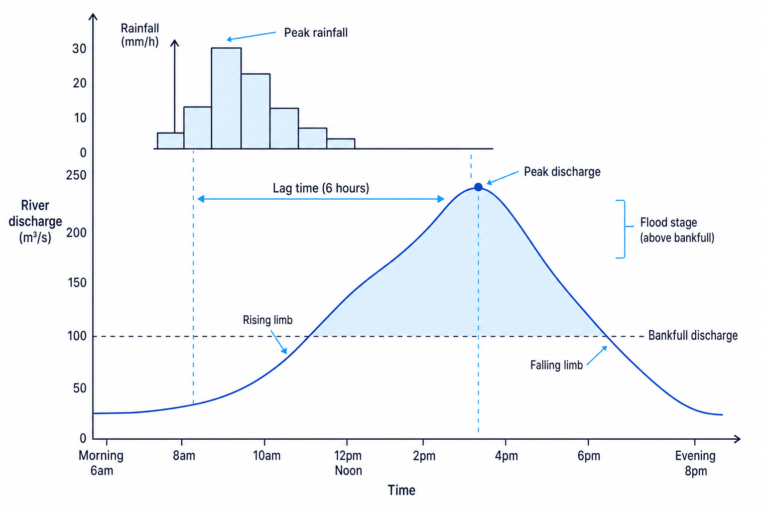
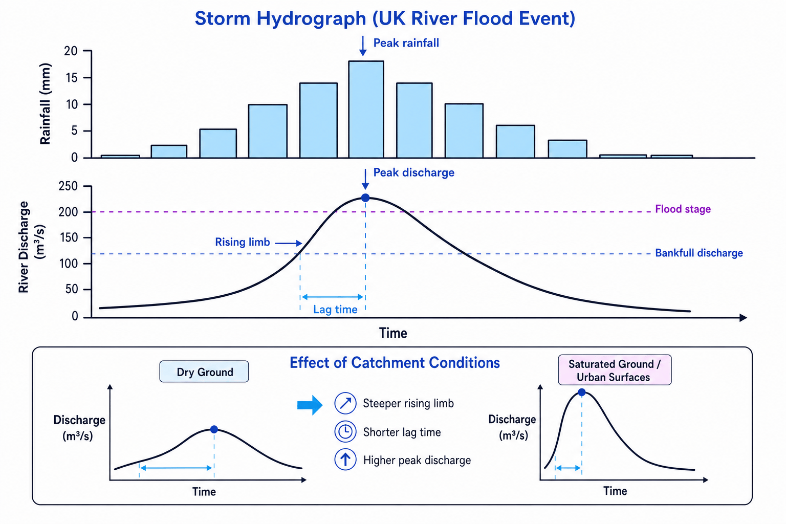
A storm hydrograph is a graph showing how a river’s discharge changes after rainfall. It helps you explain why some catchments flood quickly.
Key terms:
- Peak rainfall: the time when rainfall is heaviest.
- Peak discharge: the highest river discharge after the storm.
- Lag time: the time between peak rainfall and peak discharge.
- Rising limb: the part of the graph where discharge is increasing.
- Bankfull discharge: the discharge at which the river channel is full.
- Flood stage: the level at which flooding begins.
Interpreting a storm hydrograph
- Identify the timing: if peak rainfall is at 10:00 and peak discharge is at 16:00, the lag time is 6 hours.
- Compare discharge with the flood threshold: if peak discharge rises above bankfull discharge, the river is likely to overflow.
- Interpret the shape: a steep rising limb and short lag time suggest water reached the river quickly, often because soils were saturated or surfaces were impermeable.
Link graph shape to process
A short lag time is not just a graph feature. It is evidence of rapid surface runoff, fast channel flow, or poor infiltration in the catchment.
Case study: Somerset Levels floods, winter 2013–14
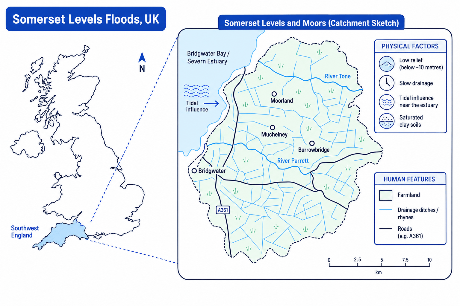
Your detailed UK flood case study can be the Somerset Levels floods. The Somerset Levels and Moors are a low-lying wetland and farming area in south-west England, mainly around the Rivers Parrett and Tone. Much of the land is below about 10 metres above sea level, so water drains away slowly.
Causes of the flood event
The Somerset floods were not caused by one factor. They happened because extreme weather affected a naturally vulnerable landscape.
| Cause | How it increased flood risk |
|---|---|
| Prolonged winter rainfall | Repeated Atlantic storms brought weeks of heavy rain. By January 2014, rainfall in parts of Somerset was widely reported as far above average, so soils became saturated. |
| Saturated soils | Once soil is full of water, new rainfall cannot infiltrate easily, so more water becomes surface runoff. |
| Low relief | The Somerset Levels are very flat, so water moves slowly through rivers, drains and rhynes. |
| Rivers Parrett and Tone | These rivers have low gradients and limited capacity, so high discharge can lead to overtopping. |
| Tidal influence | High tides in the Severn Estuary can slow the movement of river water out to sea. |
| Land use and drainage | Farming, roads and settlements occupy the floodplain, so flooding affects people quickly. Some channels also had reduced capacity because of silt and vegetation. |
Dredging
Dredging means removing sediment, silt and vegetation from a river channel to increase its capacity and help water move through it more easily.
Building a cause chain for Somerset Levels
- Start with the extreme weather: prolonged winter rainfall from repeated Atlantic storms made the catchment unusually wet.
- Add the physical landscape: the Somerset Levels are low-lying and flat, so water drains slowly towards the Rivers Parrett and Tone.
- Add the process: saturated soils reduced infiltration, increasing surface runoff into rivers and drainage channels.
- Finish with the flood outcome: river levels rose above channel capacity, flooding villages, roads and farmland across the Levels.
Blaming only dredging
Avoid saying “the flood happened because the rivers were not dredged.” Lack of dredging may have reduced channel capacity, but the main trigger was extreme, prolonged rainfall on an already wet, low-lying catchment.
Effects on people and the environment
Flood effects can be primary, meaning they happen directly during the flood, or secondary, meaning they happen later as a consequence.
| Type of effect | Somerset Levels examples |
|---|---|
| People and homes | Over 600 homes were flooded. Some residents had to leave their homes for weeks or months. Villages such as Muchelney were cut off and needed boats for access. |
| Transport and services | Roads including the A361 were closed for long periods, disrupting journeys, school access, deliveries and emergency services. |
| Farming and livelihoods | Thousands of hectares of farmland were underwater. Farmers lost income because fields, fodder and livestock systems were affected. |
| Health and wellbeing | Floodwater, isolation, insurance problems and uncertainty caused stress for residents. |
| Environment | Floodwater spread silt, sewage and pollutants across farmland and habitats. Prolonged waterlogging damaged soils and vegetation, although some wetland species can benefit from temporary flooding. |
Effects need evidence and explanation
For high marks, do not just list impacts. Explain who was affected, where they were affected, and why that impact mattered.
Management of the flood event at different scales
Flood management means actions taken to reduce flood risk or reduce damage when flooding happens. Strong case-study answers show that management happened at several scales.
| Scale | Management actions | Why it mattered |
|---|---|---|
| Local | Residents used sandbags, flood boards, pumps and boats. Local volunteers helped vulnerable people and moved supplies. | This reduced immediate risk to people and helped cut-off communities cope. |
| Regional | Somerset County Council, emergency services and the Environment Agency coordinated warnings, road closures, evacuations and temporary pumping. | Regional coordination was needed because flooding affected many villages and roads across the Levels. |
| National | The UK government, Environment Agency and military supported the response. After the floods, a Somerset Levels and Moors Flood Action Plan was developed, including dredging sections of the Rivers Parrett and Tone. | National funding and expertise supported longer-term flood-risk reduction. |
Longer-term strategies included dredging around 8 km of river channel, improving pumping stations, maintaining drainage channels, raising some road sections and creating better local flood planning. These measures reduce risk, but they cannot remove it completely because the area remains naturally low-lying and exposed to extreme rainfall.
Evaluating a flood management response
- Separate short-term response from long-term planning: boats, sandbags and emergency pumping helped during the flood, while dredging and drainage maintenance aimed to reduce future risk.
- Judge effectiveness against the problem: pumping and road closures protected people, but they could not instantly remove water from a huge, flat catchment.
- Add a balanced judgement: management improved resilience, but future floods are still possible because extreme rainfall, saturated soils and low relief remain major risk factors.
Use scale language naturally
Write phrases like “locally in Muchelney”, “regionally across Somerset”, and “nationally through government funding” to show scale without turning your answer into a list.
Bringing the case study together
A strong paragraph might follow this structure:
- Name the place and date: Somerset Levels, winter 2013–14.
- Give a specific cause linked to extreme weather.
- Explain the physical or human factor that made flooding worse.
- Use a named effect on people or the environment.
- Finish with management at one or more scales.
In the exam
- Use a named UK flood event and keep returning to it; do not drift into vague statements about “floods in general”.
- Link every cause to a process, such as saturated soil causing more surface runoff and higher river discharge.
- For management questions, cover at least two scales and make a judgement about how effective the actions were.
Check yourself
- Why did prolonged rainfall cause more flooding once the Somerset soils were saturated?
- How did the low relief of the Somerset Levels affect drainage?
- Can you give one local, one regional and one national management response to the flood?