What you'll learn
- How the world’s main climatic regions are distributed at the global scale.
- Why air moves between the equator and the poles.
- How the Hadley, Ferrel and Polar cells create pressure belts and prevailing winds.
- How circulation helps explain extreme wind, temperature and precipitation patterns.
Start with the basics: weather, climate and atmosphere
The atmosphere is the layer of gases surrounding the Earth. It is where weather happens.
Weather and climate
- Weather means the short-term conditions of the atmosphere, such as today’s temperature, wind, rain and cloud.
- Climate means the average weather conditions of a place over a long period, usually about 30 years.
A climatic region is a large area with a similar long-term pattern of temperature and precipitation. Precipitation means water falling from the atmosphere, such as rain, snow, sleet or hail.
The distribution of the main climatic regions
At the global scale, climate regions often form broad belts around the Earth. This is mainly because latitude — distance north or south of the equator, measured in degrees — affects how much energy places receive from the Sun.
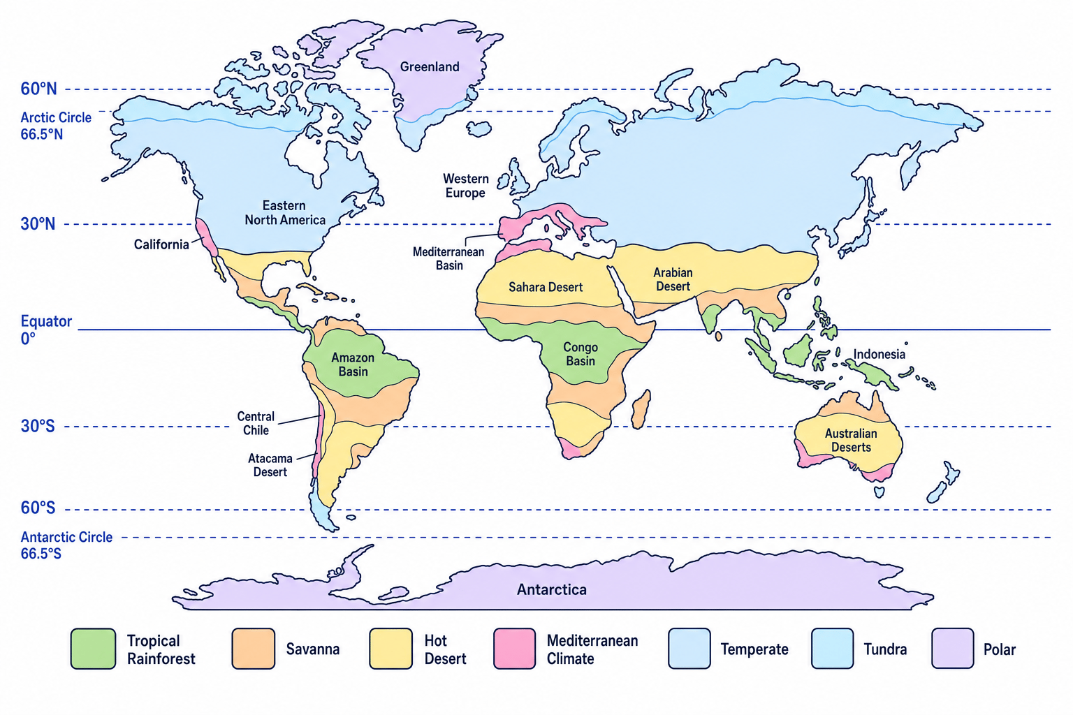
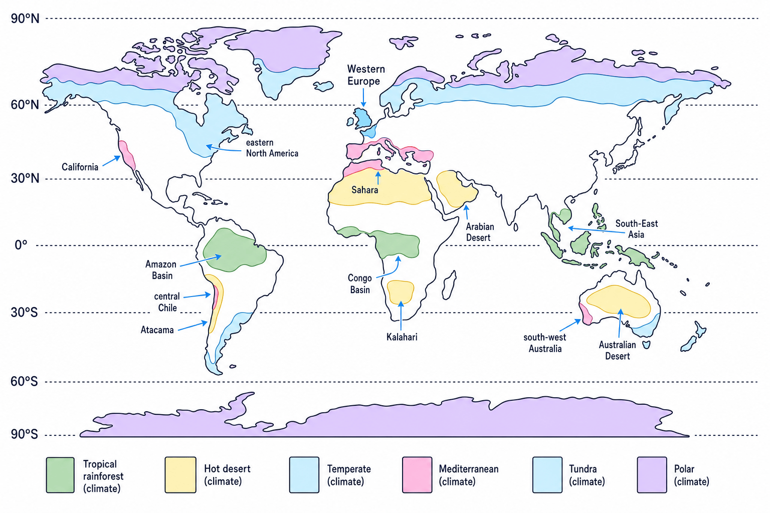
The map below is simplified, but it shows the key GCSE pattern: wetter climates near the equator, hot deserts around 20–30° north and south, temperate climates in many mid-latitude areas, and polar/tundra climates at high latitudes.
The broad pattern
- Tropical rainforest climates are close to the equator, for example the Amazon Basin in Brazil, the Congo Basin in central Africa, and parts of Indonesia and Malaysia. They are hot and very wet, often receiving over 2,000 mm of rainfall per year, although exact figures vary by location.
- Tropical grassland or savanna climates often lie north and south of the rainforest belt, for example parts of East Africa and the Sahel. They usually have a wet season and a dry season.
- Hot desert climates are common around 20–30° north and south, for example the Sahara, Arabian Desert, Atacama and Australian deserts. They often receive less than 250 mm of rainfall per year.
- Temperate climates occur in many mid-latitude areas, including western Europe and parts of eastern North America. They tend to have moderate temperatures and rainfall through the year.
- Mediterranean climates are found on some west coasts around 30–40°, such as the Mediterranean Basin, California and central Chile. They have hot, dry summers and milder, wetter winters.
- Tundra and polar climates are found at high latitudes, such as northern Canada, Greenland and Antarctica. They are very cold, with low precipitation.
Latitude gives the first clue
Climate regions are not random. A place’s latitude gives you a strong first clue about temperature and rainfall, but oceans, altitude, distance from the sea and ocean currents can modify the pattern.
Predicting a climate belt from latitude
A place is in North Africa at about 25°N. What climate would you expect?
- Use the latitude. 25°N is between 20° and 30° north, which is the usual belt for many hot deserts.
- Connect it to pressure. Around 30°N, air often sinks in a subtropical high-pressure belt, which reduces cloud formation.
- Apply it to the location. North Africa includes the Sahara, so a hot desert climate with very low rainfall is likely.
Why air moves: energy imbalance
The equator receives more concentrated insolation, which means incoming solar energy. The poles receive less concentrated energy because the Sun’s rays arrive at a lower angle and spread over a larger area.
This creates a global energy imbalance:
- the equator is usually warmer;
- the poles are usually colder;
- air and ocean currents transfer heat from lower latitudes towards higher latitudes.
Global atmospheric circulation
Global atmospheric circulation is the worldwide movement of air that helps redistribute heat from the equator towards the poles.
Warm air becomes less dense and rises. Cold air becomes denser and sinks. This vertical movement is called convection.
Pressure and wind
- Air pressure is the force of air pressing down on the Earth’s surface.
- Low pressure is linked to rising air.
- High pressure is linked to sinking air.
- Wind is the horizontal movement of air from high pressure towards low pressure.
Rising air usually brings rain
When warm, moist air rises, it cools. Cooler air can hold less water vapour, so water vapour condenses, meaning it changes into tiny water droplets. These droplets form clouds and may produce precipitation.
Sinking air usually brings dry weather
When air sinks, it is compressed and warms. This makes cloud formation less likely, so skies are often clearer and rainfall is low.
Explaining equatorial rainfall
Why do places near the equator, such as the Congo Basin, often have heavy rainfall?
- Start with heating. The equator receives intense insolation, so the ground and the air above it heat up strongly.
- Link heating to pressure. Warm air expands, becomes less dense and rises, creating low pressure at the surface.
- Explain cloud formation. As the rising air cools, water vapour condenses into clouds.
- Reach the climate outcome. Frequent rising moist air produces regular convectional rainfall, so equatorial climates are usually very wet.
The three-cell model of atmospheric circulation
The Earth does not have one simple circulation loop from equator to pole. Instead, each hemisphere has three main circulation cells.
A cell is a large loop of moving air, including rising air, upper-atmosphere movement, sinking air and surface winds.
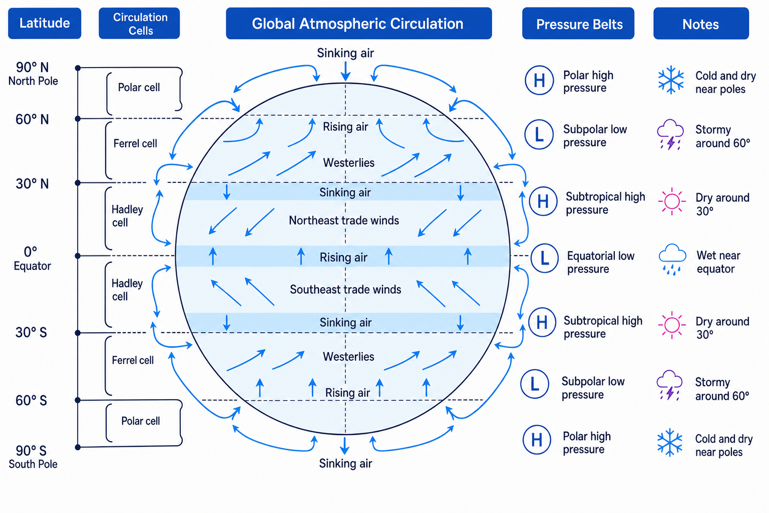
The diagram below is the core model you need to understand for this topic.
Hadley cells: 0–30° north and south
The Hadley cell operates between the equator and about 30° north or south.
- Air rises at the equator, creating an equatorial low-pressure belt.
- High in the atmosphere, air moves away from the equator.
- Around 30° north and south, air sinks, creating subtropical high-pressure belts.
- Surface winds blow back towards the equator.
These surface winds are the trade winds. In the Northern Hemisphere they are called north-east trade winds; in the Southern Hemisphere they are called south-east trade winds.
Ferrel cells: 30–60° north and south
The Ferrel cell operates between about 30° and 60° north or south. It is partly driven by the movement of the Hadley and Polar cells on either side.
Surface air moves from the subtropical high-pressure belt towards the subpolar low-pressure belt around 60°. These winds are called the westerlies because they generally blow from the west.
Polar cells: 60–90° north and south
The Polar cell operates between about 60° and the poles.
Cold, dense air sinks at the poles, creating polar high pressure. Surface air then moves towards 60°, where it meets warmer mid-latitude air and rises, creating subpolar low pressure.
The surface winds from the poles are called polar easterlies.
Coriolis effect
The Coriolis effect is the apparent deflection of winds caused by the Earth’s rotation. Winds are deflected to the right in the Northern Hemisphere and to the left in the Southern Hemisphere.
Without the Coriolis effect, winds would move more directly from high to low pressure. With it, global winds curve, creating the trade winds, westerlies and polar easterlies.
Forgetting the rotation
Do not describe winds as moving in perfectly straight north–south lines. Air does move from high pressure to low pressure, but Earth’s rotation bends the wind direction.
The ITCZ and seasonal shifts
The Intertropical Convergence Zone, often shortened to ITCZ, is the zone near the equator where the trade winds meet and air rises.
The ITCZ is not fixed in exactly the same place all year. It shifts north and south with the area receiving the most direct overhead Sun.
This helps explain regional climate patterns, such as:
- wet and dry seasons in the savanna;
- monsoon rainfall in parts of South Asia;
- drought risk in places near the edge of the tropics, such as the Sahel in Africa.
How circulation creates extreme weather conditions
Global atmospheric circulation helps explain extremes of wind, temperature and precipitation.
Precipitation extremes
Near the equator, rising air creates heavy rainfall. Tropical rainforest regions such as the Amazon and Congo Basin can experience intense daily convectional storms.
Around 30° north and south, sinking air creates dry conditions. This helps explain major desert regions such as the Sahara, Arabian Desert, Atacama and Australian deserts.
Around 60° north and south, air masses meet and rise. An air mass is a large body of air with similar temperature and moisture conditions. A front is the boundary between two air masses. When warm air is forced to rise over colder air at a front, it can produce frontal rainfall.
Temperature extremes
The equator is hot because it receives high insolation all year. However, cloud and rainfall can reduce daily temperature extremes in rainforest areas.
Hot deserts can have very high daytime temperatures because sinking air creates clear skies, allowing strong heating. At night, clear skies allow heat to escape quickly, so deserts can cool sharply.
The poles are extremely cold because they receive low-angle solar energy, and ice and snow reflect much of the incoming sunlight. Polar regions are also dry because cold air holds little moisture and sinking air discourages cloud formation.
Wind extremes
Strong winds often develop where there is a steep pressure gradient, meaning pressure changes quickly over distance. The bigger the pressure difference over a short distance, the stronger the wind is likely to be.
The westerlies can bring strong winds and storms to mid-latitude regions such as the UK, especially when low-pressure systems move across the North Atlantic.
Linking the Sahara to global circulation
Why is the Sahara so dry and often extremely hot?
- Locate it in the circulation model. Much of the Sahara lies close to 20–30°N, near the subtropical high-pressure belt.
- Explain the air movement. Air that rose near the equator moves polewards high in the atmosphere and then sinks around 30°N.
- Link sinking air to dryness. As air sinks, it warms and becomes less likely to form clouds, so rainfall is very low.
- Link clear skies to heat. Clear skies allow strong daytime heating, so temperatures can become extremely high, especially in summer.
Use the pressure clue
Low pressure usually means rising air, clouds and rainfall. High pressure usually means sinking air, clearer skies and drier conditions.
Remember: the model is simplified
The three-cell model is very useful, but real climates are also affected by other factors.
For example:
- Altitude makes places cooler, such as the Andes in South America.
- Distance from the sea affects temperature range, because oceans heat and cool more slowly than land.
- Ocean currents can warm or cool nearby coasts, such as the North Atlantic Drift helping keep western Europe milder than some places at similar latitudes.
- Relief can force air to rise over mountains, increasing rainfall on windward slopes.
Making latitude explain everything
Latitude and global circulation give the broad global pattern, but they do not explain every local detail. Add another factor if a question asks you to explain variation within a region.
In the exam
- Start with the location and latitude: equator, 30°, 60° or poles.
- Build a clear chain: heating → rising/sinking air → pressure → wind/cloud/rainfall → climate or weather outcome.
- Use the correct names: Hadley cell, Ferrel cell, Polar cell, trade winds, westerlies, polar easterlies.
- Add a named example, such as the Amazon Basin, Sahara, UK/North Atlantic or Antarctica.
- If needed, mention a modifying factor such as ocean currents, altitude or distance from the sea.
Check yourself
- Why do many hot deserts form around 20–30° north and south?
- How does the Coriolis effect change the direction of global winds?
- Why are equatorial regions usually wetter than polar regions?