

What you'll learn
- How extreme weather becomes a natural weather hazard.
- Why tropical storms form over some warm oceans but not others.
- Why droughts develop, especially in high-pressure and monsoon-margin regions.
- How the distribution and frequency of these hazards vary globally, and how they may be changing.
1. Starting point: weather, extremes and hazards
Weather means the day-to-day condition of the atmosphere, such as temperature, rainfall, wind speed, cloud cover and pressure.
Extreme weather is weather that is unusual or severe compared with the normal conditions for that place. This is important: 35°C may be normal in parts of the Sahara, but extreme in the UK.
Natural weather hazard
A natural weather hazard is a weather-related event that has the potential to harm people, damage property, disrupt services or affect ecosystems.
Extreme weather only becomes a serious hazard when it affects people or valuable environments. For example, a powerful storm over the open ocean may be less damaging than a weaker storm hitting a densely populated coast.
The big link
The hazard is not just the physical event. Risk depends on the weather event, the people and places exposed to it, and how prepared they are.
2. The atmospheric background: why air rises or sinks
At a global scale, weather hazards are linked to how the Sun heats the Earth unevenly.
The Equator receives more concentrated solar energy than the poles, so warm air near the Equator tends to rise. Rising air creates low pressure, which often brings clouds and rainfall.
At around 30° north and south of the Equator, air often sinks. Sinking air creates high pressure, which usually brings clear skies, dry conditions and low rainfall.
Atmospheric pressure
Atmospheric pressure is the force created by the weight of air pressing down on the Earth’s surface. Low pressure is linked to rising air; high pressure is linked to sinking air.
This rising and sinking pattern helps explain both hazards in this topic:
- tropical storms need warm, moist, rising air over oceans
- droughts often develop where air sinks and rainfall is suppressed
3. Tropical storms: what they are
A tropical storm is an intense low-pressure weather system that forms over warm tropical oceans. At GCSE, this usually refers to severe tropical cyclones that can produce destructive winds, torrential rain, storm surges and coastal flooding.
They have different names in different ocean basins:
- hurricanes in the North Atlantic and eastern North Pacific
- typhoons in the western North Pacific
- cyclones in the Indian Ocean and around Australia
Hurricane, typhoon and cyclone
These are not three different hazards. They are regional names for the same type of rotating tropical storm system.
4. How tropical storms form
Tropical storms need several conditions to happen at the same time.
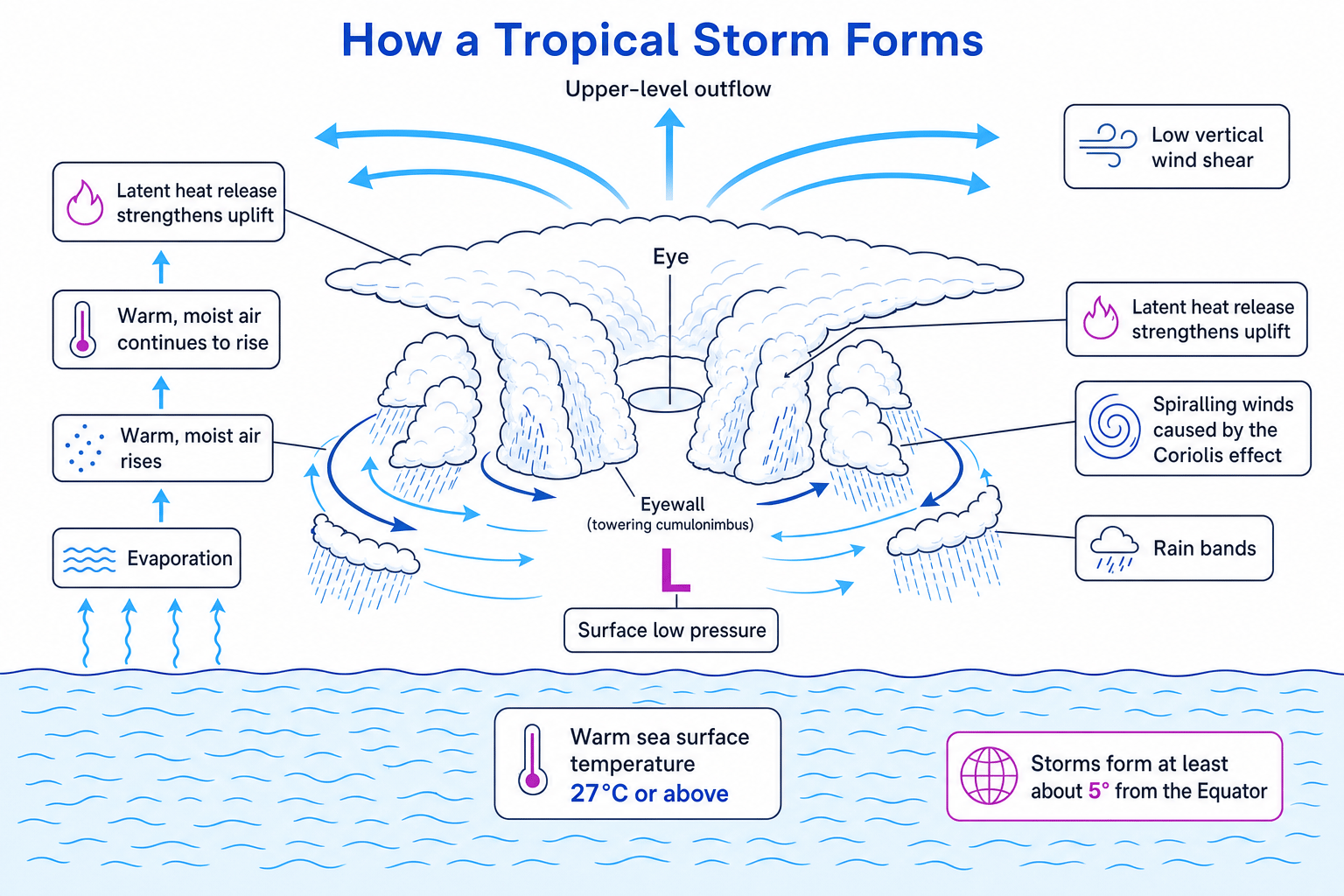
First, the sea surface usually needs to be about 27°C or warmer. Warm water increases evaporation, where liquid water changes into water vapour. This loads the air with moisture.
As warm, moist air rises, it cools and condenses into clouds. Condensation releases latent heat, which is stored heat energy. This extra heat makes the air rise even more strongly, deepening the low pressure.
The storm also needs the Coriolis effect, which is the apparent turning of moving air caused by the Earth’s rotation. This helps the storm spin. The Coriolis effect is too weak right at the Equator, so tropical storms usually form at least about 5° north or south of it.
Finally, the storm needs low vertical wind shear. Vertical wind shear means a change in wind speed or direction with height. If wind shear is too strong, it can tear the storm apart before it organises.
The diagram below shows how these processes connect inside a developing tropical storm.
Choosing where a tropical storm can form
-
A location at 12°N over an ocean with a sea surface temperature of 28°C has two key conditions: warm water and enough Coriolis effect to create rotation.
-
A location at 1°N may have very warm water, but it is too close to the Equator, so the Coriolis effect is too weak for a rotating storm to develop properly.
-
A location at 18°S over water of 25°C is far enough from the Equator, but the ocean is probably not warm enough to provide the energy needed for strong evaporation and uplift.
-
The best location is therefore the 12°N site, as it meets both the heat-energy condition and the rotation condition.
Remember the storm recipe
For tropical storms, think: warm ocean + rising moist air + spin + low wind shear.
5. Drought: what it is
A drought is a long period when rainfall is below normal, causing a shortage of water. Droughts are usually slow-onset hazards, meaning they build up over weeks, months or even years.
Drought
A drought is an extended period of unusually low water availability, usually caused by below-average rainfall and made worse when evaporation and water demand are high.
There are different types:
- meteorological drought: rainfall is below the long-term average
- agricultural drought: soil moisture is too low for crops and pasture
- hydrological drought: rivers, reservoirs and groundwater stores fall below normal
6. What causes drought?
A major cause is persistent high pressure. In a high-pressure system, air sinks. As it sinks, it warms and becomes less likely to condense into clouds, so rainfall is limited.
A long-lasting high-pressure system is sometimes called a blocking anticyclone. It can divert rain-bearing weather systems away from an area.
Drought can also be linked to the Intertropical Convergence Zone, or ITCZ. This is a seasonal belt of low pressure near the tropics where warm air rises and rainfall is common. In regions such as the Sahel in Africa, people rely on the ITCZ moving northwards to bring seasonal rain. If it does not move far enough, or the rains are weaker than usual, drought can develop.
Another cause is ENSO — the El Niño-Southern Oscillation. This is a natural pattern of changing sea temperatures and air pressure in the Pacific Ocean. El Niño and La Niña events can shift rainfall patterns around the world, contributing to drought in places such as Australia, Indonesia, southern Africa or the Horn of Africa, depending on the event.
Evapotranspiration also matters. This is water lost from the land through evaporation from surfaces and transpiration from plants. Hotter conditions increase evapotranspiration, so drought can become more severe even if rainfall only falls slightly.
Using water balance to identify drought stress
-
Suppose a region normally receives 80 mm of rain in a month, but this year it receives 30 mm. The rainfall deficit is 80−30=50 mm80 - 30 = 50\ \text{mm}80−30=50 mm.
-
Calculate the percentage decrease:
Rainfall is 62.5% below the normal monthly amount.
-
If evapotranspiration for the month is 55 mm, then rainfall is not enough to replace water being lost from the land. The shortfall is 55−30=25 mm55 - 30 = 25\ \text{mm}55−30=25 mm.
-
One dry month alone may not prove a drought, but if this pattern continues for several months, soil moisture, river flow and reservoir levels are likely to fall.
Drought is not just ‘no rain’
A place can receive some rainfall and still be in drought if the rainfall is far below normal or if heat causes water losses to be greater than water inputs.
7. Global distribution of tropical storms and drought
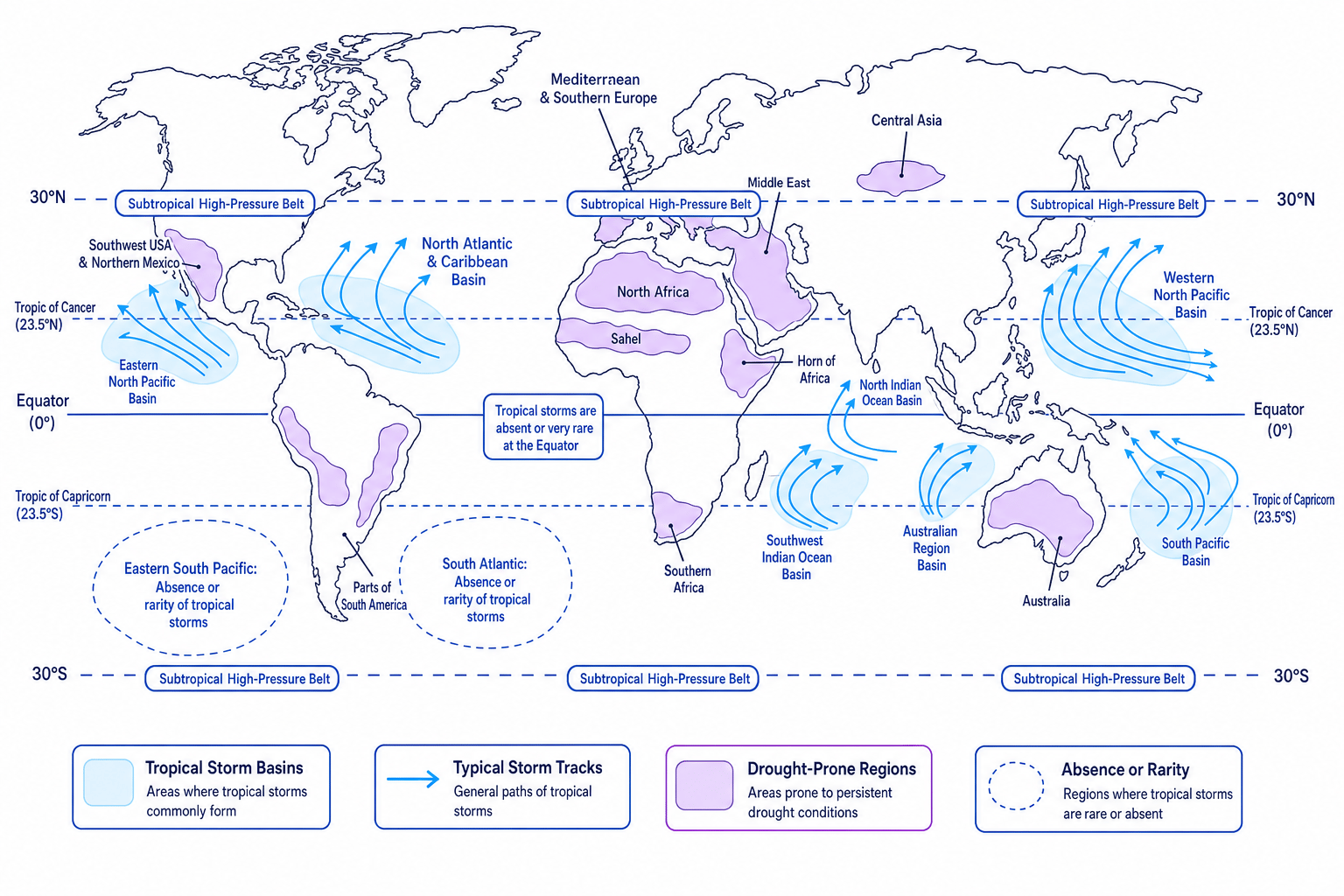
Tropical storms are mainly found over warm tropical oceans between about 5° and 30° north and south of the Equator. They are common in the North Atlantic and Caribbean, western North Pacific, north Indian Ocean, southwest Indian Ocean, around northern Australia, and parts of the South Pacific.
They are rare at the Equator because the Coriolis effect is too weak. They are also rare in the South Atlantic and eastern South Pacific because ocean conditions are usually less favourable, including cooler water and stronger wind shear.
Drought-prone areas include the subtropical high-pressure belts around 30° north and south, desert margins, continental interiors, rain-shadow areas and places with unreliable seasonal rainfall. Examples include the Sahel, the Horn of Africa, Australia, the Middle East, the Mediterranean, southwest USA and northern Mexico, and parts of southern Africa.
The map below brings these global patterns together.
Explaining a global hazard pattern
-
The western North Pacific has many tropical storms because it has large areas of very warm ocean water and enough distance from the Equator for rotation.
-
The Equator has warm water, but tropical storms are rare there because the Coriolis effect is too weak.
-
North Africa and the Middle East are drought-prone because they lie close to subtropical high-pressure belts where sinking air limits cloud formation and rainfall.
8. Frequency: how often do these hazards happen?
Frequency means how often an event occurs in a given time period. For tropical storms, frequency is often measured as the number of named storms per year in an ocean basin.
Globally, around 80 to 90 named tropical storms form in a typical year, although the exact number varies by dataset and year. Roughly half may reach hurricane, typhoon or cyclone strength. The western North Pacific is usually the most active basin.
Tropical storms also have seasonal patterns. In the Northern Hemisphere, activity is often highest in late summer and autumn, when oceans have stored the most heat. In the Southern Hemisphere, the main season is usually around January to March.
Drought frequency is harder to measure because drought has no single start date or end date. It depends on whether you are measuring rainfall, soil moisture, river flow, reservoir storage or impacts on people.
9. Have tropical storms and droughts changed over time?
This is where you need to be careful and balanced.
For tropical storms, the total global number each year has not shown a simple, clear increase. However, there is stronger evidence that the proportion of very intense storms has increased in some basins, and warmer air can hold more moisture, making extreme rainfall more likely. Rising sea level can also make storm surges more damaging.
Satellite monitoring since the 1970s has improved storm detection, especially over oceans. This means older records may have missed some storms, so long-term trends must be interpreted carefully.
For droughts, climate change can increase risk because warmer temperatures raise evapotranspiration. This can turn a dry period into a more severe hot drought. Some regions, such as the Mediterranean, southern Africa, western North America and parts of the Horn of Africa, have experienced increased drought stress or more severe drought impacts. But drought is not increasing everywhere in the same way.
Named examples you could use include Typhoon Haiyan in the Philippines in 2013, Cyclone Idai affecting Mozambique, Zimbabwe and Malawi in 2019, and the Horn of Africa drought affecting Ethiopia, Somalia and Kenya in the early 2020s. Exact impact figures vary by source, so use the figures your teacher or case-study sheet gives you.
Calculating percentage change in frequency
-
A dataset says one ocean basin averaged 10 named storms per year in an earlier period and 14 named storms per year in a later period. The increase is
14 - 10 = 4storms per year. -
Use the percentage change formula:
- Substitute the values:
- The frequency has increased by 40% in that dataset, but you should still ask whether the record length, monitoring methods and natural year-to-year variability affect the conclusion.
More reported disasters does not always mean more hazards
Reported disasters can increase because more people live in exposed places, reporting improves, or wealth and infrastructure increase. Separate the physical hazard trend from the impact trend.
In the exam
-
Separate causes, distribution and frequency/change instead of mixing them into one vague paragraph.
-
Use process words: for tropical storms, mention warm oceans, evaporation, low pressure, latent heat, Coriolis effect and low wind shear; for drought, mention high pressure, sinking air, rainfall deficit and evapotranspiration.
-
Be balanced about change over time: climate change can increase storm intensity, rainfall and drought severity, but it does not mean every place has more storms or more droughts.
-
Use named places at a global scale, such as the Philippines, Mozambique, the Sahel, the Horn of Africa or Australia, to make explanations specific.
Check yourself
- Why do tropical storms not usually form right on the Equator?
- How can high pressure lead to drought conditions?
- What is the difference between a change in tropical storm frequency and a change in tropical storm intensity?
