

What you'll learn
- Why UK National Parks have to balance conservation with development.
- How National Parks manage pressures from tourism, farming, housing and transport.
- How the UK manages river, coastal and tidal flood risk.
- How to compare management options using cost, sustainability, scale and impacts.
1. The big idea: landscapes are valuable, but under pressure
The UK’s landscapes are used in many different ways. They provide homes, jobs, food, water, recreation, wildlife habitats and beautiful scenery. That creates trade-offs: choices where gaining one benefit can cause a cost somewhere else.
This section links back to Topic 1. Your class studies two of the three landscape options — coastal, river and glaciated upland landscapes — so use examples your teacher has covered where possible.
Landscape challenge
A landscape challenge is a difficult decision about how to use, protect or manage a landscape when different groups of people and the environment have competing needs.
The core judgement
In this topic, you are rarely asked for a “perfect” solution. You are usually judging which approach is most appropriate for a particular place, time scale and group of people.
2. UK National Parks: conservation and development
A National Park is a protected landscape. In the UK, National Parks are not usually empty wilderness areas. They include villages, farms, roads, tourist attractions and working communities.
There are National Parks across England, Wales and Scotland, such as the Lake District, Peak District, Eryri / Snowdonia, Cairngorms and Loch Lomond and The Trossachs. Northern Ireland has different protected landscape designations.
National Park
A National Park is a protected area managed to conserve natural beauty, wildlife and cultural heritage, while also helping people understand and enjoy the landscape.
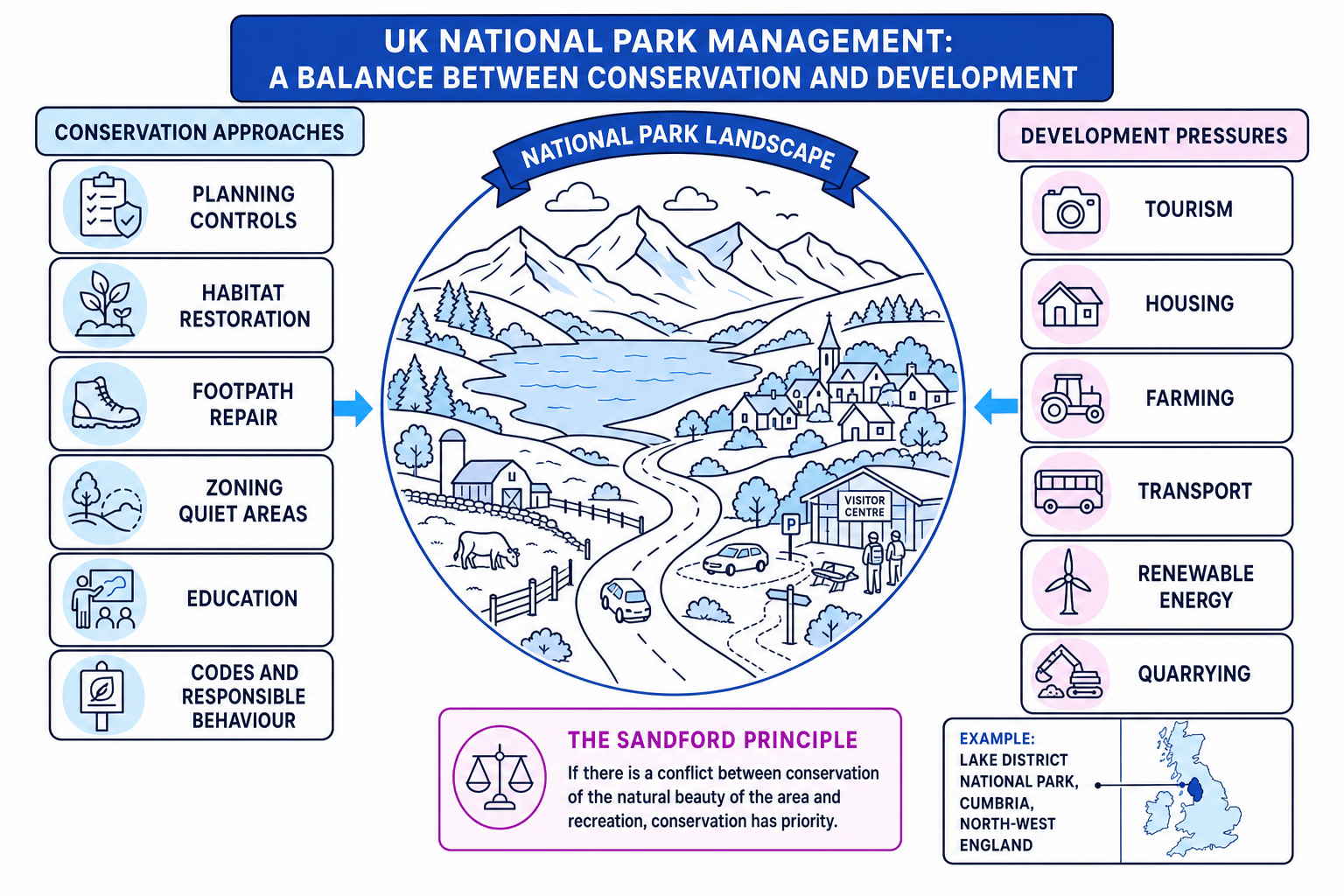
Conservation: protecting what makes the place special
Conservation means protecting and carefully managing the natural and cultural features of a place. This can include biodiversity, which means the variety of living organisms in an area, as well as historic buildings, dry-stone walls, footpaths and traditional farming landscapes.
Common conservation approaches include:
| Approach | How it works | Why it helps |
|---|---|---|
| Planning controls | New buildings, roads or quarries need permission and may be restricted | Reduces visual damage and protects habitats |
| Footpath repair | Stone pitching, boardwalks and drainage are added to popular routes | Reduces soil erosion and protects vegetation |
| Habitat restoration | Peat bogs, woodlands, wetlands or heathlands are restored | Supports wildlife, stores carbon and can slow runoff |
| Visitor zoning | Busy “honeypot” areas are managed separately from quieter sensitive areas | Allows access while reducing disturbance |
| Education and ranger work | Signs, visitor centres, guided walks and codes of conduct are used | Encourages responsible behaviour |
The Sandford Principle
If conservation and public enjoyment cannot both be achieved, conservation should be given greater weight in National Park decision-making.
Development: supporting people and local economies
Development means improving or changing land use, buildings, services or infrastructure. Infrastructure means basic systems such as roads, public transport, water supply, power lines and broadband.
Development is not automatically banned in National Parks. The aim is usually sustainable development, which means meeting present needs without damaging the ability of future generations to meet theirs.
Examples include:
- supporting local jobs through tourism, farming, forestry and small businesses
- allowing carefully designed affordable housing for local people
- improving buses, cycle routes and car parks to reduce congestion
- encouraging farm diversification, such as campsites or local food businesses
- restoring old buildings rather than building large new developments
- using local materials so buildings fit the landscape
Thinking National Parks are wilderness
Most UK National Park land is privately owned and includes farms, villages and businesses. Management is about guiding change, not simply “keeping people out”.
Located example: Lake District National Park, Cumbria
The Lake District National Park is in Cumbria, north-west England. It contains mountains, glacial lakes, valleys, farms and villages. It attracts very large visitor numbers each year — often quoted as around 18 to 20 million visits, depending on the data source and year.
Main pressures include:
- footpath erosion on popular routes such as paths near Scafell Pike and Helvellyn
- traffic congestion around places such as Windermere, Ambleside and Keswick
- pressure for second homes and holiday lets, which can affect housing affordability
- disturbance to habitats and water quality
- the need to support farming and tourism jobs
Management includes the Fix the Fells footpath repair programme, planning controls by the National Park Authority, visitor information, public transport promotion, habitat restoration and support for local communities.
Balancing a National Park development decision
A proposal is made for a large new visitor car park near a popular lake in a National Park.
-
Identify the development benefits: the car park could reduce roadside parking, improve visitor safety and support local cafés, shops and jobs.
-
Identify the conservation costs: building on open land could damage habitats, increase traffic, affect views and make the area feel less wild.
-
Consider whether impacts can be reduced: a smaller car park on previously developed land, a shuttle bus, tree screening and seasonal visitor controls could reduce damage.
-
Apply a judgement: if the scheme still causes serious landscape or habitat damage, conservation should take priority; if impacts are limited and the design reduces existing problems, a modified version may be acceptable.
3. Flood risk in UK landscapes
Flooding is a major UK landscape challenge because many towns, cities, farms, roads and railways are located on floodplains or low-lying coasts.
Flood risk
Flood risk is the chance of flooding happening combined with the likely impacts on people, property, infrastructure and ecosystems.
A river flood happens when river discharge becomes too high for the channel and water spills onto the floodplain. Discharge means the volume of water flowing past a point in a river per second.
A coastal flood happens when seawater floods low-lying land. This can be caused by high tides, large waves and storm surges, which are temporary rises in sea level caused by low pressure and strong winds. Tidal flooding affects estuaries such as the Thames in London.
Climate change is increasing the challenge because warmer air can hold more moisture, which can intensify heavy rainfall, and sea-level rise increases coastal and tidal flood risk.
4. Hard and soft engineering
Hard and soft engineering
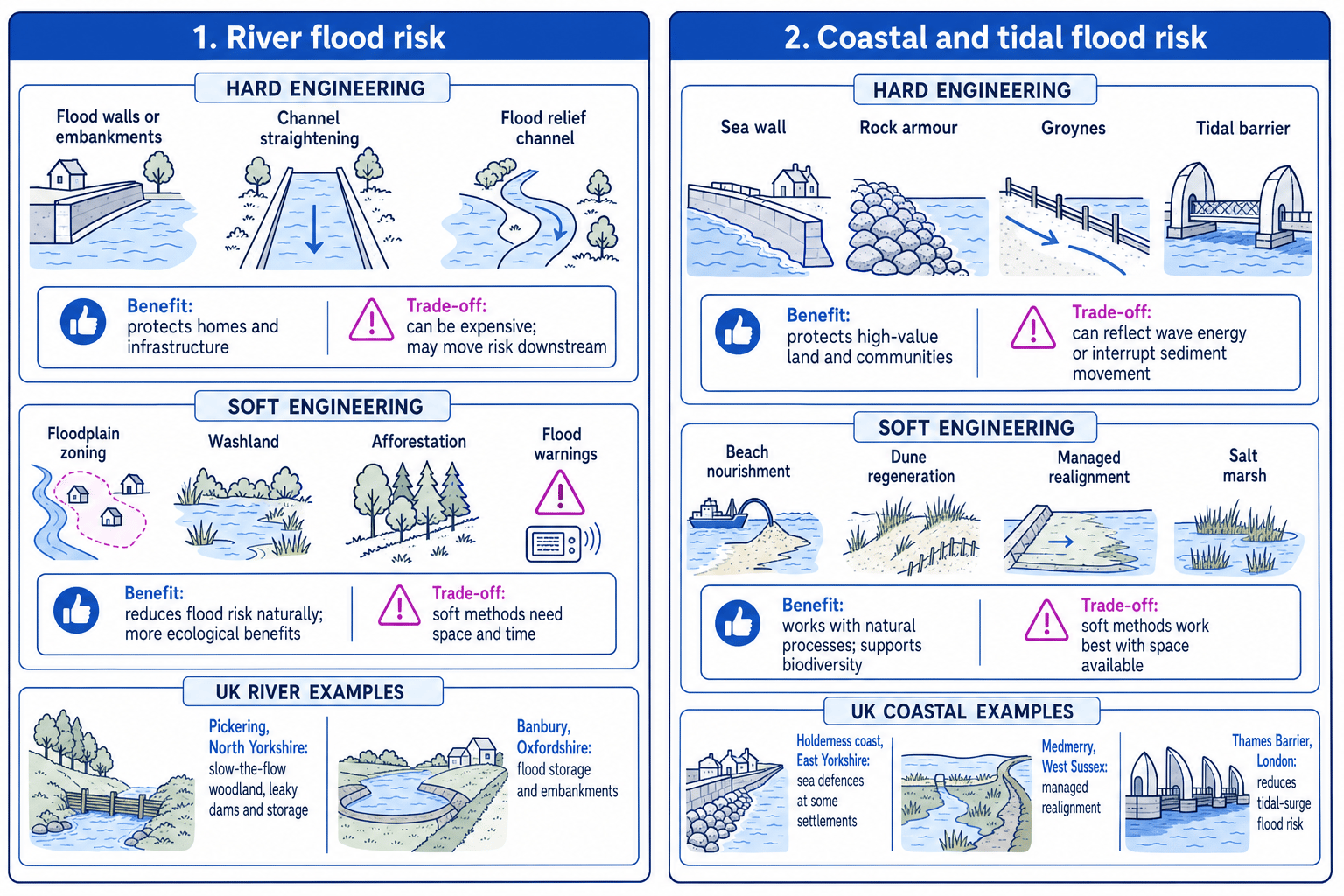
Hard engineering uses built structures such as walls, barriers and embankments. Soft engineering works more with natural processes, land-use planning and behaviour change.
River flood-risk management
River flood management is often planned across a catchment, which is the area of land drained by a river and its tributaries.
Hard engineering options include:
- embankments or flood walls to keep water within the channel
- channel straightening to move water through an area faster
- flood relief channels to divert water away from high-value areas
- dams or reservoirs to store water upstream
Soft engineering options include:
- floodplain zoning, where high-risk land is used for parks, sports fields or farming rather than housing
- washlands, which are areas deliberately allowed to flood during high flows
- afforestation, which means planting trees to intercept rainfall and slow runoff
- Natural Flood Management, such as leaky dams, restored wetlands and reconnected floodplains
- flood warnings and property-level resilience, such as raised sockets and flood doors
A good UK river example is Pickering, North Yorkshire, where “slow-the-flow” measures such as woodland planting, leaky dams and storage areas have been used to reduce peak flows. Another is Banbury, Oxfordshire, where flood storage and embankments reduce risk from the River Cherwell.
Coastal and tidal flood-risk management
Coastal management often uses Shoreline Management Plans, which set long-term policies for stretches of coastline.
Common policies include:
- Hold the line: maintain or build defences in the current position.
- Managed realignment: allow controlled flooding or erosion inland to create a more sustainable defence line.
- No active intervention: do not build new defences.
- Advance the line: build new defences further out to sea, which is rare and expensive.
Hard engineering options include sea walls, rock armour, groynes and tidal barriers. Groynes trap sediment moved by longshore drift, the movement of beach material along the coast by angled waves. This can build a wider beach locally but may reduce sediment further along the coast.
Soft engineering options include beach nourishment, dune regeneration, salt marsh creation and managed realignment. Medmerry in West Sussex is a well-known UK example of managed realignment, where land was deliberately set back from the sea to reduce flood risk and create coastal habitat.
Saying flood defences stop flooding
Most schemes reduce flood risk; they do not remove it completely. A larger storm, sea-level rise, poor maintenance or overtopping can still cause flooding.
5. Choosing the best flood-management approach
There is no single best method. You need to judge the approach against the place.
Think about:
- Cost: Can the scheme be built and maintained?
- Effectiveness: Does it reduce risk for the people and places most at risk?
- Environmental impact: Does it damage habitats or work with natural processes?
- Social impact: Who benefits and who loses?
- Scale: Is it protecting one village, a city, a whole catchment or a coastline?
- Time scale: Will it still work with climate change and sea-level rise?
A simple way to compare schemes is a benefit-cost ratio:
benefit-cost ratio=estimated benefitsestimated costs\text{benefit-cost ratio} = \frac{\text{estimated benefits}}{\text{estimated costs}}benefit-cost ratio=estimated costsestimated benefitsComparing flood-management options
Imagine a council is comparing two possible flood schemes using estimated costs and benefits.
-
For Scheme A, the estimated benefit is £120 million and the cost is £40 million, so the ratio is 12040=3.0\frac{120}{40}=3.040120=3.0. This suggests £3 of benefit for every £1 spent.
-
For Scheme B, the estimated benefit is £45 million and the cost is £30 million, so the ratio is 4530=1.5\frac{45}{30}=1.53045=1.5. This suggests £1.50 of benefit for every £1 spent.
-
Compare the numbers with wider impacts: Scheme A has the stronger economic case, but if it damages habitats or increases flood risk downstream, Scheme B may be more sustainable in the long term.
A strong evaluation sentence
Use this pattern: “This approach is appropriate in this place because…, however it may be less suitable where… Therefore…” It helps you move beyond description into judgement.
In the exam
-
For National Parks, name and locate the park, then explain the tension between conservation and development.
-
For flood management, classify the approach as hard engineering, soft engineering, planning or warning, then evaluate its strengths and limits.
-
Finish with a justified judgement: explain which option is most suitable for that place, not just which option sounds best in general.
Check yourself
- How does the Sandford Principle influence decisions in UK National Parks?
- Why might a flood wall reduce risk in one place but increase problems elsewhere?
- When might managed realignment be more suitable than holding the line?
