

Welcome to your study notes for Section 1.3 of the Edexcel GCSE Geography (1GA0) specification. This section is part of the physical geography topic The changing landscapes of the UK.
Optionality reminder
In Paper 1: The physical environment, you are assessed on two of three UK landscapes: Coastal landscapes, River landscapes, or Glaciated upland landscapes. If your class has chosen River landscapes, these notes are essential reading for you!
What you'll learn
- The physical processes of weathering, mass movement, erosion, transport, and deposition that shape river environments.
- How a river's profile and channel change from source to mouth, using the River Tees as our UK located example.
- How distinctive erosional and depositional landforms develop.
- How human activities affect rivers, and how we manage the physical and human causes of flooding.
1. Physical Processes Shaping River Landscapes
Rivers do not exist in a vacuum; they are dynamic systems shaped by five key physical processes that wear down, move, and deposit material along their course.
Weathering and Mass Movement
Before sediment even enters a river channel, physical processes on the surrounding valley slopes prepare and deliver material to the water.
Weathering
Weathering is the breakdown of rock in situ (where it is, without moving) by physical, chemical, or biological processes.
- Mechanical (physical) weathering: The most common type in the UK is freeze-thaw weathering. Water enters cracks in a rock, freezes, and expands by about 9% in volume. This puts pressure on the rock. When it melts, more water enters the deeper crack. Repeated freezing and thawing eventually shatters the rock.
- Chemical weathering: Acidic rainwater (caused by dissolved carbon dioxide) reacts with minerals in rocks like limestone, dissolving them over time.
- Biological weathering: Plant roots grow into cracks and split rocks apart, or burrowing animals weaken valley slopes.
When weathering weakens the valley slopes, gravity pulls the loose material down towards the river channel. This is called mass movement.
Mass Movement
Mass movement is the downhill movement of rock, soil, or mud under the influence of gravity.
- Sliding (landslides): Blocks of rock slide rapidly down a flat, steep slope along a slide plane.
- Slumping: Saturated soil and weak rock slide downhill along a curved slip plane, creating a stepped slope.
River Erosion
As water flows, it exerts energy on the river bed and banks, wearing them away.
Erosion
Erosion is the wearing away and removal of rock and soil along the river bed and banks by the force of the water and the load it carries.
- Hydraulic action: The sheer force of the moving water forces air into cracks in the river bed and banks. The trapped air is compressed, expanding explosively when the pressure is released, shattering the rock.
- Abrasion: The river's load (pebbles and stones) scrapes and grinds against the bed and banks, wearing them away like sandpaper.
- Attrition: Rocks and pebbles carried by the river knock against each other, breaking into smaller, rounder, and smoother pieces.
- Solution (corrosion): Soluble minerals (like calcium carbonate in limestone) are dissolved in the slightly acidic river water and carried away.
River Transport
Once material is eroded or delivered to the channel by mass movement, the river transports it downstream.
Transportation
Transportation is the movement of eroded material (the river's load) downstream.
- Traction: Large, heavy boulders are rolled along the river bed. This requires very high energy.
- Saltation: Small pebbles and stones bounce along the river bed in a leapfrog motion.
- Suspension: Fine, light material (like silt and clay) is carried along within the body of the water, making the river look cloudy or muddy.
- Solution: Dissolved minerals are carried invisibly in the water.
River Deposition
When a river loses energy, it can no longer transport its load, so it drops it.
Deposition
Deposition occurs when a river's velocity (speed) drops, reducing its energy and causing it to leave behind the sediment it was carrying.
A river drops its heaviest load (large boulders) first because they require the most energy to move. The lightest sediment (fine silt) is transported the furthest and deposited last, often near the river's mouth.
Climate and Weather Influences
The UK's weather and climate strongly affect these processes:
- Short-term storms: Intense rain storms cause rapid surface runoff, rapidly increasing a river's volume of water (discharge). This raises the river's velocity, triggering high rates of hydraulic action and abrasion, and allowing the river to transport much larger sediment.
- Droughts: Extended dry periods reduce water levels, slowing velocity and causing widespread deposition.
- Seasonal climate: UK winters increase freeze-thaw weathering on valley slopes, supplying more loose rock to the river system.
2. Long Profiles, Cross Profiles, and the River Tees
As a river flows downstream from its upland source to its lowland mouth, its landscape changes dramatically.
Long Profile and Cross Profile
- Long profile: A line showing how a river's gradient (steepness) changes from its source to its mouth. It is typically a concave curve.
- Cross profile: A cross-section slice across the river valley at a specific point, showing the shape of the valley and the river channel.

The Three Courses of a River
| Feature | Upper Course (Upland) | Middle Course | Lower Course (Lowland) |
|---|---|---|---|
| Gradient | Steep and uneven | Medium | Very gentle / flat |
| Valley Profile | Narrow, steep-sided, V-shaped | Wider, flat valley floor with sloping sides | Very wide and flat (floodplain) |
| Channel Width | Narrow | Medium | Very wide |
| Channel Depth | Shallow | Medium | Deep |
| Velocity | Low (friction from rough bedload slows water down) | Medium | High (efficient channel with less friction) |
| Discharge | Low | Medium | High (many tributaries have joined) |
| Sediment Shape | Large, angular, sharp | Medium, rounder | Small, very round, fine silt (mud) |
Located Example: The River Tees
To meet the Edexcel requirement for a named UK river landscape, we study the River Tees in northeast England.
- Location: The Tees flows 137 km from its upland source at Cross Fell (Pennines) eastward to its lowland mouth at Teesmouth near Middlesbrough, where it enters the North Sea.
- Upper Course: It starts about 600m above sea level. Here, geology plays a huge role. It runs over hard, resistant igneous rock called Whin Sill. This results in vertical erosion, forming a steep-sided V-shaped valley and the famous High Force Waterfall (the UK's largest waterfall by volume, dropping 21m).
- Middle Course: As the gradient decreases, lateral (sideways) erosion dominates. The river meanders across a wider valley floor near Barnard Castle.
- Lower Course: The river flows through a flat, wide floodplain. It has large meanders, levees, and a wide estuary surrounded by heavy industry at Teesport.
3. River Landforms
River landforms are categorised by the processes that create them: erosion, deposition, or a mixture of both.
Erosional Landforms
Interlocking Spurs
In the upper course, the river has low discharge and vertical erosion dominates. The river does not have the energy to erode laterally through hillsides, so it winds its way around fingers of harder rock that jut into the valley. These fingers are called interlocking spurs.
Waterfalls and Gorges
When a river flows over an area of alternating hard (resistant) rock and soft (less resistant) rock, a waterfall forms.
- The river erodes the soft rock faster than the hard rock, creating a step in the river bed.
- Water rushing over the step hydraulic-actions and abrades the soft rock underneath, creating a plunge pool.
- Over time, the hard cap-rock is left overhanging because its support below has been eroded away.
- Eventually, gravity causes the overhanging hard rock to collapse into the plunge pool.
- This process repeats over thousands of years, causing the waterfall to retreat upstream, leaving behind a steep-sided valley called a gorge.
Geology at High Force
At High Force on the River Tees, the hard cap-rock is Whin Sill (an igneous rock), which sits on top of softer sandstone and limestone. The erosion of this underlying soft rock has caused the waterfall to retreat, leaving a spectacular 700m gorge downstream.
Depositional Landforms
Floodplains and Levees
- Floodplain: A wide, flat area of land on either side of a river in its middle and lower courses. During a flood, the river overflows its banks. Because water spreading over the land is shallow and meets friction from grass and soil, its velocity drops instantly. It deposits its finest sediment (alluvium), which builds up over successive floods to form a fertile floodplain.
- Levees: Naturally raised banks along the edges of the river channel. When the river floods, the heaviest, coarsest sediment is deposited first, right next to the channel edge. Over time, this coarse material builds up into high ridges.
Erosional and Depositional Landforms
Meanders and Oxbow Lakes
Meanders are sweeping bends in a river, created by a combination of lateral erosion and deposition.
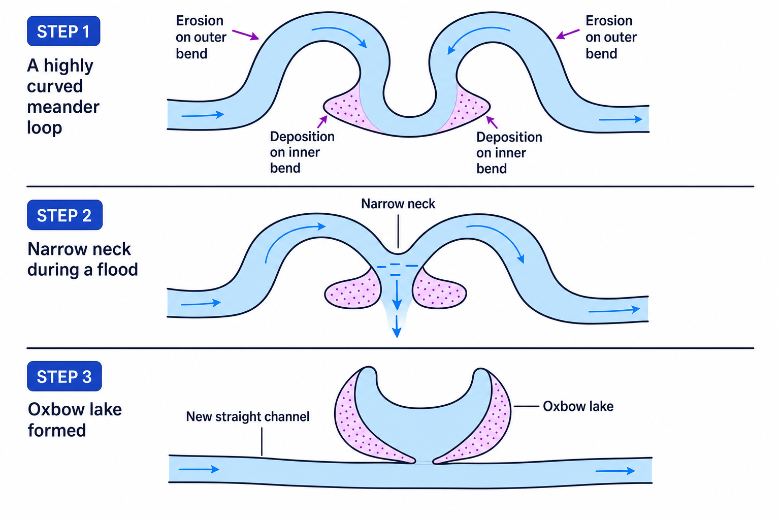
- Outer Bend (Erosion): Water flows fastest on the outer bend of a meander loop because it has the most momentum. This high velocity causes lateral erosion (abrasion and hydraulic action), cutting into the bank and forming a steep river cliff.
- Inner Bend (Deposition): On the inside of the bend, water is slow-moving. Because velocity is low, the river deposits sand and gravel, forming a gently sloping beach called a slip-off slope (or point bar).
- Oxbow Lakes: Over time, lateral erosion narrows the neck of the meander loop. During a period of high discharge (a flood), the river takes the straightest, fastest route, cutting directly through the narrow neck. Deposition eventually seals off the old meander loop, leaving a crescent-shaped oxbow lake.
4. Flooding and Human Interventions
Flooding occurs when a river's discharge exceeds the capacity of its channel, causing water to overflow onto the surrounding land.
Causes of Flooding
| Physical Causes | Human Causes |
|---|---|
| Heavy Rainfall: Intense storms saturate the soil quickly, preventing infiltration and forcing water to run over the surface (surface runoff). | Urbanisation: Building roads and houses creates impermeable surfaces (concrete/tarmac). Water cannot infiltrate; it flows rapidly into drains and straight into the river. |
| Geology: Impermeable rocks (like granite or clay) prevent water from soaking into the ground, speeding up runoff. | Deforestation: Cutting down trees removes vegetation that would otherwise intercept rain and absorb water through their roots. |
| Relief: Steep-sided slopes in upland areas cause water to run quickly down into the river channel. | Agriculture: Ploughing crops down slopes creates channels for water to run off quickly. Soil compaction from tractors prevents infiltration. |
Storm Hydrographs
Geographers use storm hydrographs to show how a river's discharge responds to a specific rainfall event.
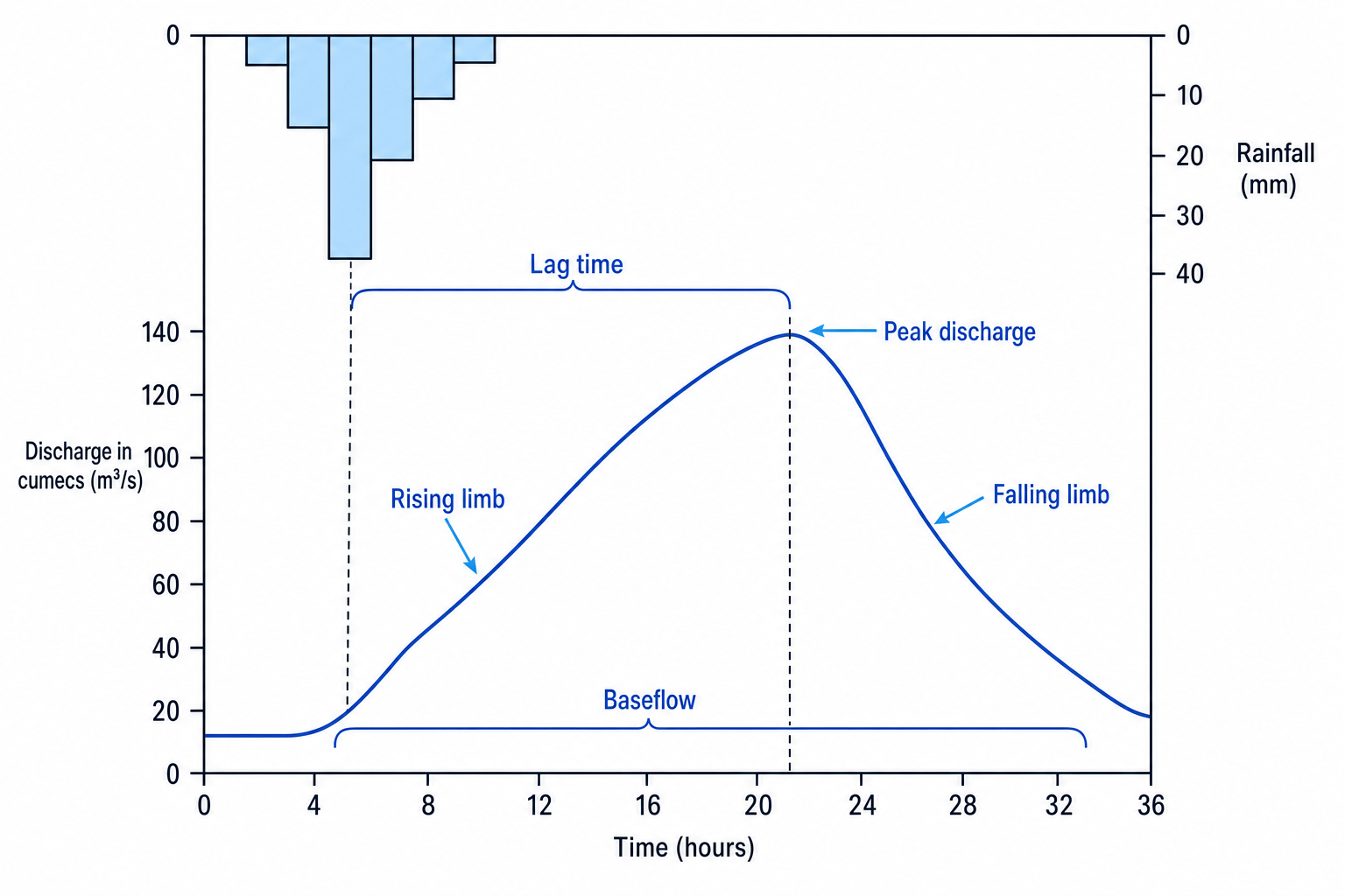
Storm Hydrograph Terms
- Peak Rainfall: The hour of highest rainfall.
- Peak Discharge: The maximum flow of water in the river channel (measured in cubic metres per second, or cumecs, written as m3/s\text{m}^3/\text{s}m3/s).
- Lag Time: The time delay between peak rainfall and peak discharge.
- Rising Limb: The rapid rise in discharge as water flows into the river.
- Falling Limb: The decrease in discharge as water drains away.
Watch your lag time units!
Always check the x-axis scale on a hydrograph before calculating lag time. It is usually measured in hours, but occasionally it can be written as dates or 24-hour clock times.
Let's look at a practical example of how to calculate a river's lag time using data from a hydrograph.
Calculating lag time from a storm hydrograph
A geographer wants to calculate the lag time of a river after a heavy rainfall event.
- The bar chart shows that the peak rainfall occurred at 06:00 (6 AM).
- The line graph shows that the peak discharge reached the gauging station at 20:00 (8 PM) on the same day.
How long is the lag time?
- Identify the time of peak rainfall:
- Identify the time of peak discharge:
- Calculate the difference between these two points in time:
The lag time of the river is 14 hours.
Managing Flooding: Hard vs. Soft Engineering
Flood defences protect settlements and infrastructure from the devastating impacts of flooding.
Hard Engineering
This involves building artificial, heavy structures to control the flow of the river.
- Dams and Reservoirs: Huge concrete walls built across a river valley to trap water in a reservoir.
- Advantage: Very effective at regulating water flow; can generate renewable hydroelectric power (HEP).
- Disadvantage: Extremely expensive; floods massive areas upstream, displacing communities and destroying habitats.
- Channelisation: Straightening or deepening the river channel so water flows away faster.
- Advantage: Protects the immediate urban area by removing water quickly.
- Disadvantage: Speeds up the water, increasing the risk of severe flooding further downstream.
Soft Engineering
This uses natural processes and working with nature to reduce the risk of flooding.
- Flood Plain Zoning: Restricting what can be built on different parts of the floodplain. Low-value land (like parks or pasture) is placed near the river, while high-value buildings (homes, hospitals) are built far away.
- Advantage: Inexpensive and preserves natural habitats without disrupting the river.
- Disadvantage: Limits where towns can grow; cannot protect existing buildings already built on the floodplain.
- Washlands: Areas on the floodplain deliberately allowed to flood safely during high discharge.
- Advantage: Absorbs excess water naturally and creates wetland habitats.
- Disadvantage: Farmland within the washlands cannot be used for crops during flood season.
In the exam
- Be dynamic with landform explanations: When explaining how waterfalls or oxbow lakes form, use sequencing words like firstly, over time, as a result, and subsequently. This shows the examiner you understand the step-by-step process.
- Name-drop your UK river case study: If a question asks about river landforms, profiles, or management in the UK, make sure to explicitly write "River Tees", and name-drop specific locations like Cross Fell (source), High Force (waterfall and Whin Sill geology), and Teesport (estuary/lower course).
- Link geology to profiles: Be ready to explain how geology dictates landforms. For example, hard rock (Whin Sill igneous rock) resists erosion and forms waterfalls, whereas softer clays erode easily to form wide valleys.
- Identify landforms on OS maps (Skill 11): On a 1:25,000 OS map, look for tightly packed, parallel contour lines to identify a steep valley (upper course) or a gorge. Spot meanders by looking for looped river shapes on flat land where contour lines are very sparse.
Check yourself
- Can you describe the difference between traction and saltation?
- Why does the long profile of a river change from a steep gradient to a gentle gradient?
- Explain how the hard Whin Sill geology of the River Tees led to the formation of High Force Waterfall.
- What is the difference between a rising limb and a falling limb on a storm hydrograph?
- Why might channelisation protect one town but increase flood risk for a town downstream?
