

Welcome to your study notes for Coastal landscapes and processes (Specification Section 1.2, Topic 1A).
An Optional Topic
In the Edexcel GCSE Geography A specification, Topic 1 (The changing landscapes of the UK) requires you to study two out of three physical landscapes: Coasts (1A), Rivers (1B), or Glaciation (1C). Check with your teacher to ensure you are studying Coasts!
What you'll learn
- Physical Processes: How weathering, mass movement, erosion, transportation, and deposition shape the coast.
- Geology and Waves: How rock types, coastal structures, and wave types dictate the rate of coastal change.
- Distinctive Landforms: The step-by-step formation of erosional features (like arches and stacks) and depositional features (like spits and bars).
- Human Management: The social, environmental, and economic impacts of coastal recession, and the hard and soft engineering methods used to combat it.
- UK Case Study: An in-depth look at a located example (the Dorset Coast) to see how physical structure and human choices interact.
1. Physical Processes at Work on the Coast
The coastline is a highly dynamic zone where the land meets the sea. It is constantly being shaped by a combination of sub-aerial (on land) processes and marine (sea) processes.
Weathering and Mass Movement
Before waves can erode a cliff, sub-aerial processes weaken the rock from above.
Weathering
The breakdown of rocks in situ (in their original place) by the action of the weather, plants, and animals, without the involvement of a moving agent like waves or glaciers.
Weathering occurs in three main ways:
- Mechanical (physical) weathering: The physical disintegration of rock without changing its chemical makeup. The most important GCSE example is freeze-thaw weathering. Rainwater collects in rock cracks. When temperatures drop below 0 ∘C0\text{ }^\circ\text{C}0 ∘C, the water freezes and expands by approximately 9%, exerting pressure on the surrounding rock. Over repeated cycles of freezing and thawing, the rock fractures and breaks away.
- Chemical weathering: The decomposition of rock caused by chemical reactions. For example, rainwater is slightly acidic because it absorbs carbon dioxide from the atmosphere to form weak carbonic acid. This acid reacts with calcium carbonate in alkaline rocks like limestone and chalk, dissolving them (carbonation).
- Biological weathering: The breakdown of rocks by living organisms. Plant roots grow into small cracks, wedging them apart as they expand. Burrowing animals (like rabbits) can also destabilize soft cliff faces.
Once cliffs are weakened by weathering, gravity can trigger mass movement.
Mass Movement
The downslope movement of rock, soil, or mud under the direct influence of gravity.
On UK coastlines, you need to know two main types of mass movement:
- Sliding: Occurs when rock or debris moves rapidly downslope along a flat, linear slip plane (often a fault or joint).
- Slumping (rotational slip): Occurs when material moves downslope along a curved slip plane. This is highly common in clay cliffs after heavy rainfall. The permeable clay absorbs water, becomes extremely heavy, and loses its internal strength, causing the cliff face to slide downwards and rotate backwards.
Marine Processes: Waves, Erosion, Transport, and Deposition
The energy that shapes the coast comes primarily from waves. Waves are generated by the wind blowing over the surface of the sea. Their power depends on three factors:
- The wind speed.
- How long the wind has been blowing.
- The fetch (the distance of open water over which the wind has blown).
Constructive vs. Destructive Waves
The coastline experiences two very different types of waves depending on weather conditions:
| Feature | Constructive Waves | Destructive Waves |
|---|---|---|
| Wave Height | Low (under 1 m1\text{ m}1 m) | High (over 1 m1\text{ m}1 m) |
| Wave Frequency | Low (666 to 888 per minute) | High (101010 to 141414 per minute) |
| Swash vs. Backwash | Strong swash, weak backwash | Weak swash, strong backwash |
| Impact on Beach | Deposits sediment (builds up beach) | Erodes sediment (destroys beach) |
Swash and Backwash
- Swash: The forward movement of water up a beach after a wave breaks.
- Backwash: The backward movement of water down a beach under the influence of gravity.
Marine Erosion
Destructive waves wear away the land using four key processes:
- Hydraulic Action: The sheer force of the water crashing against the cliff. Waves trap air in cracks along the cliff face. As the wave hits, this air is highly compressed, exerting massive pressure. When the wave retreats, the air expands explosively, shattering the surrounding rock.
- Abrasion: Waves pick up stones and sand and hurl them against the cliff base, acting like sandpaper to chip away the rock.
- Attrition: Rocks and pebbles carried by the waves smash into one another, breaking into smaller, smoother, and more rounded fragments. Note: Attrition does not erode the cliff itself; it wears down the sediment.
- Solution: Soluble chemicals in seawater (such as acids) slowly dissolve specific rock types, particularly chalk and limestone.
Marine Transportation and Longshore Drift
Once material is eroded, it is moved along the coast by waves and currents.
The Four Methods of Transportation
- Traction: Large boulders are rolled along the seabed.
- Saltation: Small pebbles and stones are bounced along the seabed.
- Suspension: Fine sand and clay particles are carried along within the water column.
- Solution: Dissolved minerals are carried in the water invisible to the naked eye.
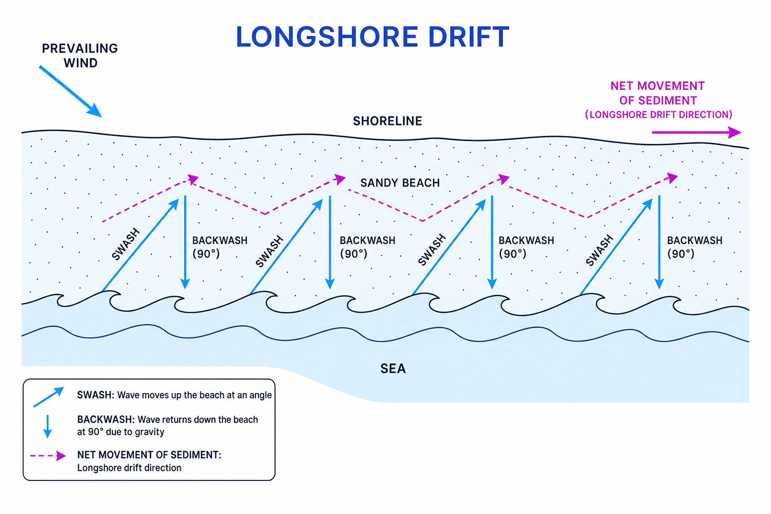
When waves approach the coast at an angle, sediment is transported along the shoreline in a zig-zag process called Longshore Drift (LSD).
- The prevailing (dominant) wind drives waves to approach the beach at an angle.
- The swash carries sediment up the beach at this same diagonal angle.
- The backwash pulls sediment straight down the beach (at a 90∘90^\circ90∘ angle) due to gravity.
- Repeated cycles move sediment along the coastline in a clear directional path.
Deposition
When waves lose their energy, they can no longer carry sediment. The material is dropped, which is known as deposition. This happens in sheltered environments (like bays), where there is a wide beach to slow waves down, or where there is a shallow sea.
2. The Influence of Geology and Climate
The rate at which physical processes change the coast depends heavily on geological structure and weather patterns.
Geological Structure: Rock Type and Alignment
- Hard rock vs. Soft rock: Resistant rocks like granite, limestone, and chalk erode very slowly. Soft rocks like clay and glacial till (boulder clay) have little resistance and erode rapidly.
- Joints and Faults: Joints are small, natural cracks in rock layers; faults are larger fractures caused by past tectonic movement. Waves easily exploit these zones of weakness.
The alignment of rock bands relative to the sea determines the type of coastline:
Discordant and Concordant Coastlines
- Discordant Coastline: Bands of alternating hard and soft rock run perpendicular (at a right angle) to the shoreline.
- Concordant Coastline: Bands of alternating hard and soft rock run parallel to the shoreline.
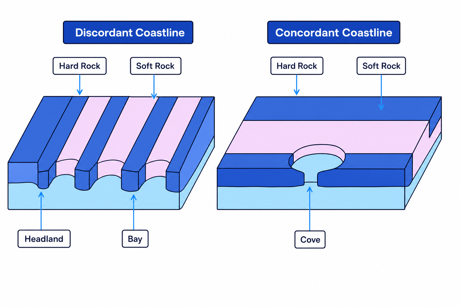
- On discordant coastlines, selective erosion occurs. The soft rock is eroded rapidly to form bays, while the resistant hard rock remains sticking out as headlands.
- On concordant coastlines, the outer hard rock acts as a protective barrier. However, if waves break through this hard barrier (via a fault), they rapidly erode the softer rock behind it, creating circular, protected inlets called coves (such as Lulworth Cove).
The Influence of UK Weather and Climate
The UK's climate directly accelerates or decelerates rates of coastal erosion:
- Prevailing winds: The UK’s dominant winds come from the South West, bringing high-energy waves across the Atlantic Ocean with a massive fetch. This drives intense erosion on the South and West coasts.
- Storm frequency: Winter depressions bring severe storms, generating highly destructive waves that strip beaches of sand and aggressively attack cliff bases.
- Seasonality: Cold winter temperatures increase freeze-thaw weathering on cliff faces, while heavy winter rainfall saturates cliffs, triggering slumping.
Calculating the mean rate of coastal erosion
Geographers track coastal recession over multi-year datasets to plan coastal defenses.
Suppose a surveyor monitors a cliff edge on the East coast of England from a fixed reference point (a stone marker 100 m100\text{ m}100 m inland) over a 15-year period.
- In Year 0 (2008), the distance from the marker to the cliff edge is 85.4 m85.4\text{ m}85.4 m.
- In Year 15 (2023), the distance from the marker to the cliff edge has dropped to 51.2 m51.2\text{ m}51.2 m.
Calculate the mean annual rate of coastal erosion over this period to 2 decimal places.
- Calculate the total distance eroded: Subtract the final distance from the initial distance:
- Identify the time period: The duration of the study is:
- Divide the total erosion by the number of years: Calculate the mean annual rate:
The mean annual rate of coastal erosion is 2.28 m/year2.28\text{ m/year}2.28 m/year.
3. Coastal Landforms
Physical processes create distinctive erosional and depositional landforms along the coastline.
Erosional Landforms
Cliffs and Wave-Cut Platforms
When destructive waves attack the base of a cliff, they erode a notch at the high-tide mark called a wave-cut notch. As the notch gets deeper, the cliff above becomes unsupported and eventually collapses under gravity. This process repeats over time, causing the cliff to retreat inland. Behind the retreating cliff, a flat, rocky shelf called a wave-cut platform is left exposed at low tide.
Caves, Arches, Stacks, and Stumps
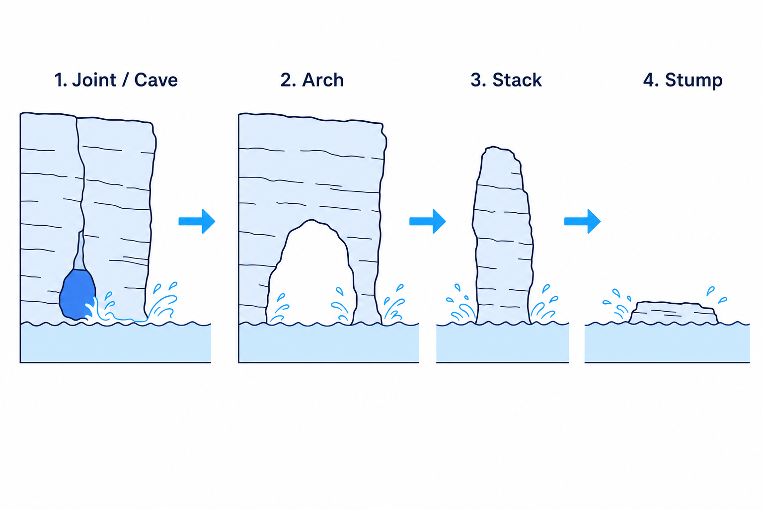
On headlands, erosion targets structural weaknesses like faults and joints to create a sequence of iconic landforms:
- Caves: Hydraulic action and abrasion widen a joint or fault at the base of the headland.
- Arches: Marine erosion continues from both sides of the headland until two caves join together, or one cave cuts completely through the headland.
- Stacks: Sub-aerial weathering weakens the roof of the arch, while marine erosion widens the arch base. Eventually, the roof collapses under gravity, leaving an isolated pillar of rock standing in the sea called a stack.
- Stumps: Waves erode the base of the stack until it collapses, leaving a low-lying remnant called a stump, which is often covered at high tide.
Depositional Landforms
Beaches
Beaches form in sheltered environments (like bays) where constructive waves deposit sand or shingle.
Spits
A spit is an elongated ridge of sand or shingle that extends out from the coast into the sea or a river estuary.
- Spits form where the coastline suddenly changes direction.
- Longshore drift continues to transport sediment in the original direction, pushing it out into open water.
- If the wind direction changes temporarily, it causes the end of the spit to curve inland, creating a hooked end.
- Behind the spit, the water is highly sheltered, allowing fine silt to deposit and form a salt marsh.
Bars
A bar is created when longshore drift grows a spit across a bay, joining two headlands together. This traps a body of freshwater behind it, forming a lagoon.
4. Human Intervention and Coastal Management
Human Activities Impacting Coastlines
- Urbanisation: Building homes and infrastructure along cliffs increases their weight and alters drainage, sometimes accelerating mass movement. It also puts valuable assets at high risk of coastal flooding.
- Agriculture: Clearing natural vegetation for farming exposes soil to wind and rain weathering, destabilizing cliffs.
- Industry: Quarrying cliff faces or dredging offshore gravel beds can starve beaches of sediment, increasing the power of incoming waves.
Coastal Defences: Hard vs. Soft Engineering
Communities must decide how to manage coastal recession. They can use high-impact, artificial structures (hard engineering) or work with natural processes (soft engineering).
Hard Engineering
- Sea Walls: Large concrete walls placed at the foot of cliffs to reflect wave energy back to sea.
- Advantage: Highly effective at preventing erosion and flooding.
- Disadvantage: Extremely expensive to build (approx. £5,000 per metre) and maintain; can look ugly.
- Groynes: Wooden or stone barriers built at right angles to the shore to trap sediment moved by longshore drift.
- Advantage: Builds up a wider beach, which naturally absorbs wave energy and supports tourism.
- Disadvantage: Starves beaches further down the coast of sediment, dramatically increasing erosion elsewhere.
- Rip Rap (Rock Armour): Large, durable boulders piled up at the foot of a cliff or sea wall.
- Advantage: Cheap compared to sea walls; absorbs wave energy by letting water flow between the gaps.
- Disadvantage: Rocks are often imported from abroad (high carbon footprint); can restrict beach access.
Soft Engineering
- Beach Nourishment: Pumping sand or shingle onto an eroding beach to make it wider and higher.
- Advantage: Looks completely natural; boosts tourism; relatively cheap.
- Disadvantage: Needs constant, costly replacement as waves continue to transport the sand away.
- Managed Retreat: Allowing low-value land (like farmland) to flood naturally by removing existing defences or choosing not to build new ones.
- Advantage: Creates valuable salt-marsh habitats; highly sustainable and cheap.
- Disadvantage: Compensation must be paid to farmers/homeowners who lose their land; highly controversial.
Confusing Swash/Backwash with Hard/Soft Engineering
Do not confuse marine wave actions with human management strategies. In exam descriptions of groynes, make sure you explain that they halt longshore drift, not the swash and backwash of individual waves.
5. Case Study: The Dorset Coast (Located Example)
The Dorset Coast in Southern England is a world-famous, highly distinctive coastal landscape designated as a UNESCO World Heritage Site. It is the perfect example of how geology and physical processes interact.
                  [THE DORSET COASTLINE]

     West                                         East
     Chesil Beach -----> Lulworth Cove -----> Swanage Bay & Old Harry Rocks
    (Deposition)           (Concordant)            (Discordant / Erosion)
Swanage Bay and Studland Bay (Discordant Coastline)
On the eastern side of the Dorset coast, the geology runs perpendicular to the shoreline.
- Resistant bands of Chalk and Purbeck Limestone form prominent headlands (such as Ballard Point and Durlston Head).
- Soft bands of Wealden Clay and Sands have been eroded much faster by destructive waves, forming the deep sheltered bays of Swanage Bay and Studland Bay.
Old Harry Rocks (Erosional Landforms)
At the end of Ballard Point (a chalk headland), intense hydraulic action and abrasion have exploited vertical joints. Over hundreds of years, this has formed a classic cave-arch-stack sequence. Old Harry is a large chalk stack, and Old Harry's Wife is a nearby stump that collapsed in 1896 due to storm-induced erosion.
Lulworth Cove (Concordant Coastline)
On the southern side of the Dorset coast, the geological bands run parallel to the shore.
- The outer layer facing the sea is highly resistant Portland Limestone.
- Behind this lies soft Purbeck Clay and Wealden Sands.
- Marine erosion exploited a fault line (weakness) in the Portland Limestone, breaking through it. Once through, the waves quickly eroded the soft clays behind, carving out a perfectly circular, sheltered cove.
Chesil Beach (Depositional Landform)
Chesil Beach is a massive, 29 km29\text{ km}29 km long shingle bar (and spit system) that connects the mainland to the Isle of Portland. It traps a brackish lagoon called The Fleet behind it. The bar was shaped by longshore drift and dominant south-westerly waves pushing massive quantities of gravel along the coast.
In the exam
- Annotate your maps: You may be asked to identify coastal landforms on 1:25,000 or 1:50,000 Ordnance Survey (OS) maps. Look for spits (long sand tongues stretching into estuaries), cliffs (closely packed contour lines right at the sea boundary), and sandy beaches (yellow shaded areas with beach labels).
- Connect human choices to physical impacts: If a question asks you to evaluate a coastal defence strategy, always trace the knock-on physical impact. For example: "Building groynes at Place A protects its beach, but starves Place B down-drift of sediment, leading to accelerated cliff recession and slumping at Place B."
- Use the "Case Study" wisely: When writing about the Dorset Coast, use specific geographical names (e.g., Lulworth Cove, Old Harry Rocks, Swanage Bay, Portland Limestone) to gain full marks for your located place knowledge.
Check yourself
- Can you explain the difference in wave dynamics between constructive and destructive waves?
- Why do rotational slumps occur primarily on clay cliffs after heavy rainfall?
- How does the orientation of geology on a concordant coastline differ from that of a discordant coastline, and what landforms does each produce?
- What are the environmental and economic trade-offs of using managed retreat instead of sea walls?
