

What you'll learn
- How past glaciers eroded, transported and deposited material in UK uplands.
- How today’s weather, freeze-thaw and mass movement continue to modify these relict landscapes.
- How to recognise key glacial landforms such as corries, arêtes, U-shaped valleys, moraines and drumlins.
- How people change glaciated uplands, using the Lake District as a located example.
This is one of the optional landscape choices in Topic 1: your class studies two from coastal, river and glaciated upland landscapes.
1. What is a glaciated upland landscape?
A glacier is a large mass of ice that moves slowly under its own weight. In the past, parts of upland Britain were covered by glaciers during colder periods of the Pleistocene — the long period of repeated ice ages before the current warmer period.
Glaciated upland landscape
A glaciated upland landscape is a highland area shaped by glaciers, especially through erosion, transport and deposition of rock material.
Most UK glaciated uplands are now relict landscapes. This means they were mainly formed under past conditions that no longer operate in the same way. The UK has no active valley glaciers today, but places such as the Lake District, Snowdonia/Eryri and the Scottish Highlands still show the landforms left behind.
2. Glacial processes: erosion, transport and deposition
Glaciers shape land through three main process groups: erosion, transport and deposition.
Glacial erosion
Erosion means the wearing away and removal of rock. Glaciers erode mainly by plucking and abrasion.
Plucking happens when meltwater enters cracks in rock, freezes onto the glacier, and then pulls blocks of rock away as the ice moves. It is especially effective on the downstream or lee side of rock obstacles.
Abrasion happens when rocks frozen into the base of the glacier scrape and grind the valley floor and sides, like sandpaper. This smooths and deepens the landscape.
Glaciers are powerful because they move debris
Ice on its own can erode, but ice carrying rock fragments is much more effective: it can scrape, polish, deepen and steepen valleys over long periods.
Glacial transport
Transport means the movement of material. A glacier can carry rock debris:
- on top of the ice, after rockfalls from valley sides
- within the ice, after debris becomes frozen into it
- under the ice, dragged along at the base
The transported material ranges from fine clay to huge boulders.
Glacial deposition
Deposition means dropping material. A glacier deposits debris when it melts, slows down or loses energy.
Till and moraine
Till is unsorted glacial debris, containing many particle sizes mixed together. A moraine is a landform made from deposited till, often as a ridge or sheet.
Unlike a river, a glacier does not sort material neatly by size. That is why glacial deposits are often a messy mixture of clay, sand, gravel and boulders.
3. Processes acting on glaciated uplands today
Today, UK upland glacial landscapes are mainly changed by weathering, mass movement, rivers, vegetation and human activity.
Weathering is the breakdown of rock in place. It does not involve movement away from the original location. A key type in uplands is mechanical weathering, where rock is physically broken apart.
Freeze-thaw weathering
Freeze-thaw weathering happens when water enters cracks in rock, freezes, expands, and forces the crack wider. When it thaws, more water can enter, and the cycle repeats.
This is most common when temperatures fluctuate above and below 0°C and there is plenty of water from rain, snow or meltwater.
Mass movement
Mass movement is the downslope movement of material under gravity. In glaciated uplands it includes:
- soil movement, such as slow creep or wet soil slipping downslope
- rockfalls, where loosened blocks fall from steep slopes
- rockslides, where rock moves down a slip surface
These processes are common on steep corrie backwalls, valley sides and slopes weakened by freeze-thaw.
Weather, climate and process rates
Weather means short-term atmospheric conditions, such as today’s temperature and rainfall. Climate means average weather conditions over a longer period, usually about 30 years.
Seasonal variation means changes through the year. Diurnal variation means changes between day and night.
UK uplands are often colder, wetter and windier than lowland areas. Western uplands, such as the Lake District and Snowdonia/Eryri, receive high rainfall because moist Atlantic air is forced to rise over mountains. This is relief rainfall: air cools as it rises, water vapour condenses, and rain falls.
Using weather data to assess freeze-thaw risk
A simplified upland weather extract shows: night minimum temperature -2°C, day maximum temperature 4°C, and monthly rainfall 160 mm.
- Compare the night minimum with 0°C: at -2°C, water in cracks can freeze and expand.
- Compare the day maximum with 0°C: at 4°C, ice can thaw, allowing more water to enter cracks.
- Use the rainfall evidence: 160 mm suggests plenty of water is available, so repeated freeze-thaw is likely and rockfall risk may increase on steep slopes.
Saying glaciers are still eroding UK valleys
Do not write as if glaciers are currently carving most UK upland valleys. The major glacial landforms are relict features from past colder climates; today, weathering, mass movement, rivers and people mainly modify them.
4. Erosional landforms in glaciated uplands
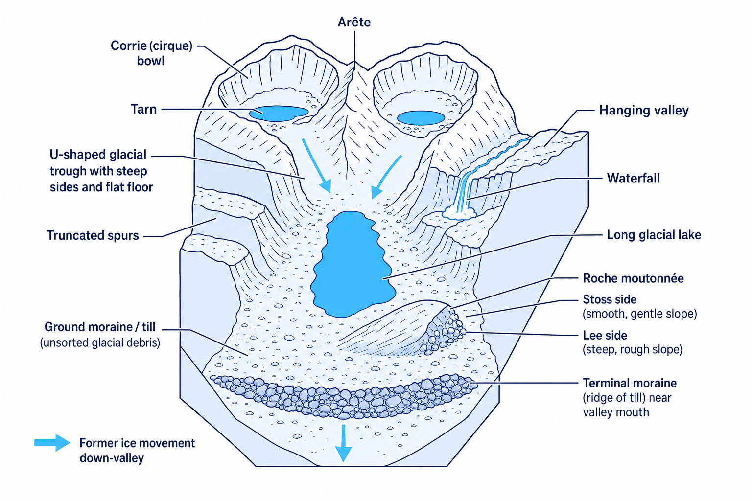
Glacial erosion creates distinctive landforms. The diagram below brings several of them together in one upland valley system.
Corries and tarns
A corrie is a deep, armchair-shaped hollow on a mountainside. Snow gathers in a sheltered hollow, compresses into ice, and begins to move in a circular motion called rotational slip. Plucking steepens the back wall, while abrasion deepens the hollow.
When the ice melts, water may collect in the hollow to form a tarn, which is a small mountain lake.
Arêtes
An arête is a narrow, sharp ridge between two corries or glaciated valleys. It forms when erosion works backwards on both sides, leaving a steep ridge between them. Striding Edge in the Lake District is a famous example.
Glacial troughs, truncated spurs and hanging valleys
A glacial trough is a U-shaped valley with steep sides and a flatter floor. It often begins as a V-shaped river valley, but a glacier widens, deepens and straightens it.
Truncated spurs are the ends of former interlocking spurs that have been cut off by glacial erosion. They appear as steep, blunt valley sides.
A hanging valley forms where a smaller tributary glacier joins a larger main glacier. The smaller glacier erodes less deeply, so after the ice melts its valley is left “hanging” above the main trough. Waterfalls often form where the tributary stream drops into the main valley.
Glacial lakes
A glacial lake can form where ice overdeepens part of a valley or where moraine dams water. Long, narrow lakes in glacial troughs are often called ribbon lakes. Windermere and Ullswater in the Lake District are good UK examples.
Roche moutonnée
A roche moutonnée is an asymmetrical rock mound shaped by ice. The stoss side faces the oncoming ice and is smoothed by abrasion. The lee side is steeper and rougher because plucking removes blocks of rock.
Landform explanation shortcut
For most erosional landforms, build your answer in this order: original shape, ice movement, named processes, final landform.
5. Depositional and mixed landforms
Glacial deposition produces landforms made from till. Some landforms involve both erosion and deposition.
Ground moraine and terminal moraine
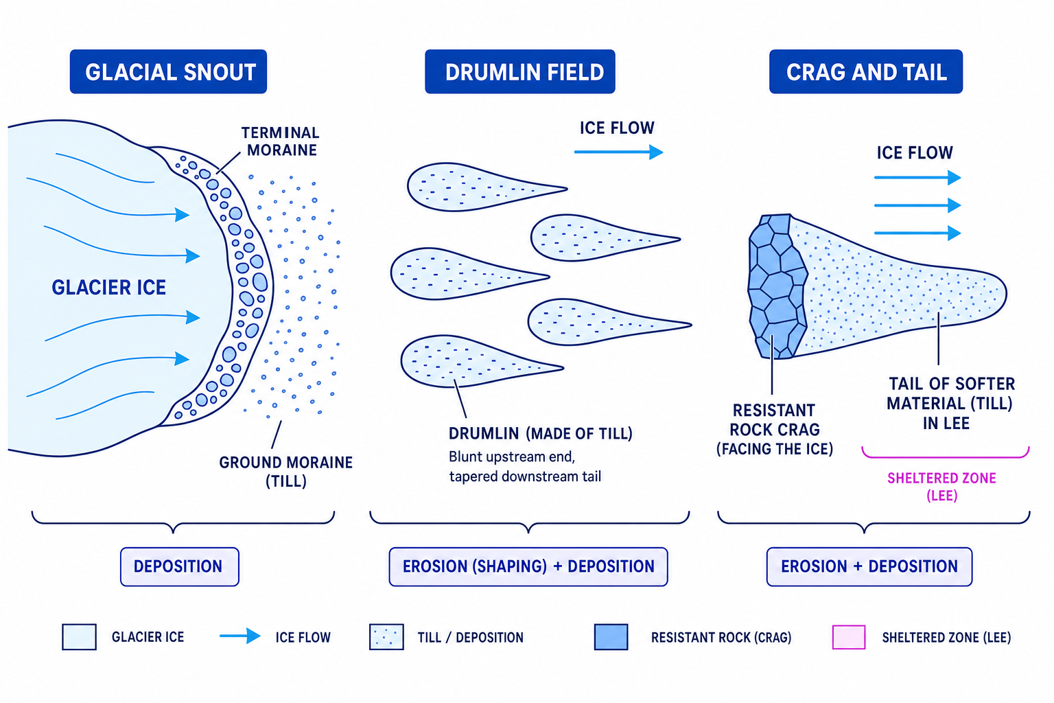
Ground moraine is a spread of till left across the valley floor as ice melts. It can create uneven, hummocky ground.
Terminal moraine is a ridge of till deposited at the furthest point reached by a glacier. It marks the glacier’s maximum advance. Terminal moraines may also help dam lakes after the ice retreats.
Drumlins
A drumlin is a smooth, elongated hill made mostly of till. Drumlins usually occur in groups called drumlin fields. They have a blunt end facing the direction the ice came from and a tapered tail pointing in the direction of ice movement.
Drumlins show interaction between deposition and ice movement: material is deposited and then streamlined beneath moving ice.
Crag and tail
A crag and tail forms where resistant rock protects softer material behind it. The glacier erodes around the hard crag, while material is deposited or preserved in the sheltered tail on the lee side. Edinburgh Castle Rock is a well-known UK example, although it is an urban example rather than a remote upland one.
6. Recognising glacial landforms on OS maps
On 1:25 000 and 1:50 000 OS maps, you use contour patterns, water features and place-name clues.
- Corries often appear as horseshoe-shaped hollows with close contours on the back wall and sometimes a small blue tarn.
- Arêtes appear as narrow ridges with close contours on both sides.
- Glacial troughs have wide, flatter valley floors with steep sides shown by close contours.
- Truncated spurs appear as steep blunt slopes projecting into a main valley.
- Hanging valleys may show a tributary stream or waterfall entering above a larger valley.
- Drumlins appear as repeated oval contour patterns aligned in the same direction.
Identifying a glacial trough from map evidence
Imagine an OS map extract shows a long valley with a lake along the floor, close contours on both sides, a road on the flat valley bottom, and blunt spurs along the edges.
- Use the contour spacing: close contours on both sides show steep valley sides, while fewer contours on the floor suggest flatter land.
- Use the valley shape: a long, straight valley with a flat floor is more like a glacial trough than a narrow V-shaped river valley.
- Use supporting evidence: the lake and blunt spurs fit glacial overdeepening and truncated spurs, so the best identification is a glacial trough.
7. How human activities change glaciated uplands
People do not create the original glacial landforms, but they can speed up erosion, alter drainage, change vegetation and affect slope stability.
Farming
Upland farming is often based on sheep grazing. Grazing can keep vegetation short, and overgrazing can expose soil. Bare soil is more easily washed away by rain or moved downslope by trampling and gravity.
Drainage and burning may also alter runoff. Less vegetation means less interception, so water reaches the ground more quickly and erosion risk can rise.
Forestry
Forestry can stabilise slopes because tree roots bind soil and tree canopies intercept rainfall. However, conifer plantations and forestry tracks can also change drainage patterns.
Clear-felling removes tree cover suddenly, leaving bare soil exposed. Heavy machinery may compact soil, reducing infiltration and increasing surface runoff.
Settlement and infrastructure
Settlements, roads and car parks are often found on valley floors because they are flatter. Building creates impermeable surfaces, which increase runoff. Roads cut into slopes can destabilise them, increasing the chance of small landslides or rockfalls.
8. Development: advantages and disadvantages
Glaciated uplands are attractive places for development because they have steep slopes, high rainfall, strong winds, lakes and impressive scenery.
Water storage and supply
Reservoirs store water for towns and cities. They can provide reliable water supply and sometimes support flood control or hydroelectric power. However, reservoirs may flood valley floors, alter river flow, affect habitats and change the appearance of the landscape.
Renewable energy
Uplands may be suitable for hydroelectric power and wind energy. These produce low-carbon electricity and may bring income. Disadvantages include visual impact, access-road erosion, noise, wildlife disturbance and conflict with tourism or conservation.
Recreation and tourism
Walking, climbing, cycling, boating and sightseeing bring jobs and income to rural areas. But popular routes can suffer footpath erosion, litter, traffic congestion and pressure on local housing.
Conservation
Conservation protects habitats, landforms and cultural landscapes. It may include footpath repair, grazing management and restrictions on new building. However, restrictions can create conflict if local people feel farming, housing or business opportunities are limited.
GIS
A Geographic Information System is a digital system used to store, map and compare layers of spatial data, such as land use, slopes, roads, footpaths and erosion risk.
You can use OS maps and GIS to investigate human intervention by comparing human features with physical features: for example, reservoir dams in narrow valleys, forestry on steep slopes, roads along valley floors, and footpaths crossing fragile ridges.
Assessing the impact of a reservoir proposal
A proposed reservoir would flood part of a glacial trough but provide water for a nearby city.
- Identify the physical change: flooding the valley floor would cover till, river habitats and possibly parts of the original glacial trough landscape.
- Weigh the benefit: a reservoir could improve water security, especially during dry periods or rising demand.
- Make a balanced judgement: it may be justified if water need is high, but the best answer should also consider mitigation, such as habitat creation, careful dam design and limits on access-road damage.
9. Located example: the Lake District, Cumbria
For your named UK located example, you can use the Lake District in Cumbria, north-west England. It is part of the UK’s upland west and is influenced by moist Atlantic air, so it is generally wet, cool and well suited to strong weathering and slope processes today.
The Lake District is mainly an igneous upland landscape, with hard volcanic rocks in areas such as the Borrowdale Volcanic Group. Its national context matters: it is a National Park, a major UK tourist destination, and an important water-supply area for north-west England.
How it formed
During the last glacial period, ice accumulated in the central Lake District and moved outwards through existing valleys. Abrasion and plucking deepened and widened valleys into glacial troughs. Overdeepened sections later became ribbon lakes such as Windermere and Ullswater.
Corries formed high on mountain sides, including Red Tarn below Helvellyn. Arêtes such as Striding Edge formed where corries eroded back towards each other. Moraines were left as ice retreated, and freeze-thaw later produced scree on steep slopes.
Most significant factors causing change
The Lake District is changing because of both physical and human processes.
Physical change includes heavy rainfall, freeze-thaw, rockfalls and slope wash. Intense rainfall events can increase flooding and erosion in valleys.
Human change is very significant. Tourism brings large numbers of visitors, with exact totals varying by year and source, often in the tens of millions of visits annually. Popular routes such as those around Helvellyn and Scafell Pike suffer footpath erosion, so projects such as Fix the Fells repair paths using stone pitching and drainage.
Water supply has also changed the landscape. Thirlmere and Haweswater were modified as reservoirs to supply urban areas, including Manchester and north-west England. This brought major benefits for water supply but also flooded valley land and altered the visual landscape.
Best judgement for the Lake District
The original landforms were created by past glaciation, but the most visible recent changes are often caused by tourism, water management, farming and conservation decisions interacting with wet upland weather.
In the exam
- Link every landform to a named process: for example, corrie plus rotational slip, plucking and abrasion.
- Use map evidence precisely: contours, blue water features, valley shape, ridges, roads and settlement patterns.
- For human-impact questions, give both benefits and costs, then make a judgement about which impact is most significant.
- For the located example, set it in its UK context: name the place, region, rock type, formation and current pressures.
Check yourself
- How are plucking and abrasion different?
- What OS map evidence would help you identify a corrie, an arête and a glacial trough?
- In the Lake District, which has caused more recent visible change: physical processes or human activity? Why?
