What you'll learn
- How the UK’s main rock types are distributed across the country.
- Why upland and lowland landscapes often look different.
- How glaciers, rivers, weathering, climate and slope processes shaped the UK after past ice ages.
- How farming, forestry and settlement have changed the appearance of UK landscapes over time.
The starting point: what is a physical landscape?
A physical landscape is the visible shape and character of the land, including hills, valleys, rivers, cliffs, rocks, soils and vegetation. In the UK, landscapes vary a lot over short distances: compare the steep mountains of Snowdonia/Eryri with the flat Fens of eastern England.
A useful first division is between uplands and lowlands.
Uplands and lowlands
Uplands are areas of higher land, often with steeper slopes, thinner soils and more exposed conditions. Lowlands are areas of lower, flatter or gently rolling land, often with deeper soils and more settlement.
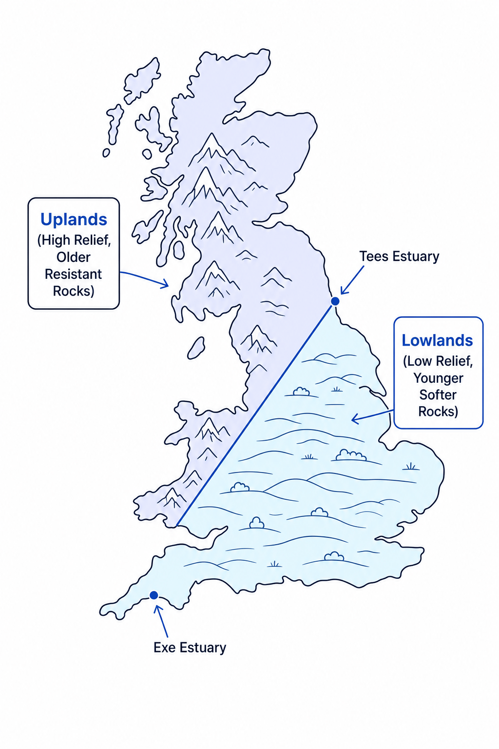
The UK’s uplands are mostly in the north and west, including the Scottish Highlands, Lake District, Pennines, Snowdonia/Eryri and parts of south-west England. Lowlands are more common in the south and east, including the London Basin, East Anglia, the Fens and the Vale of York.
This simplified map shows the broad pattern. Remember: it is a national overview, so there are local exceptions, such as the Pennines, which are upland but include resistant sedimentary rocks.
Geology: the rock foundations of the landscape
Geology
Geology means the rocks beneath the ground and how they were formed, arranged and changed over time.
Rock type matters because different rocks have different levels of resistance. A resistant rock is harder to wear away by erosion and weathering. Less resistant rocks are worn away more easily, often forming lower, gentler landscapes.
The UK’s main rock types
There are three main rock groups you need for this overview.
Sedimentary rocks
Sedimentary rocks form when layers of sediment, such as sand, mud, shells or tiny sea creatures, are compacted and cemented together over time.
In the UK, important sedimentary rocks include:
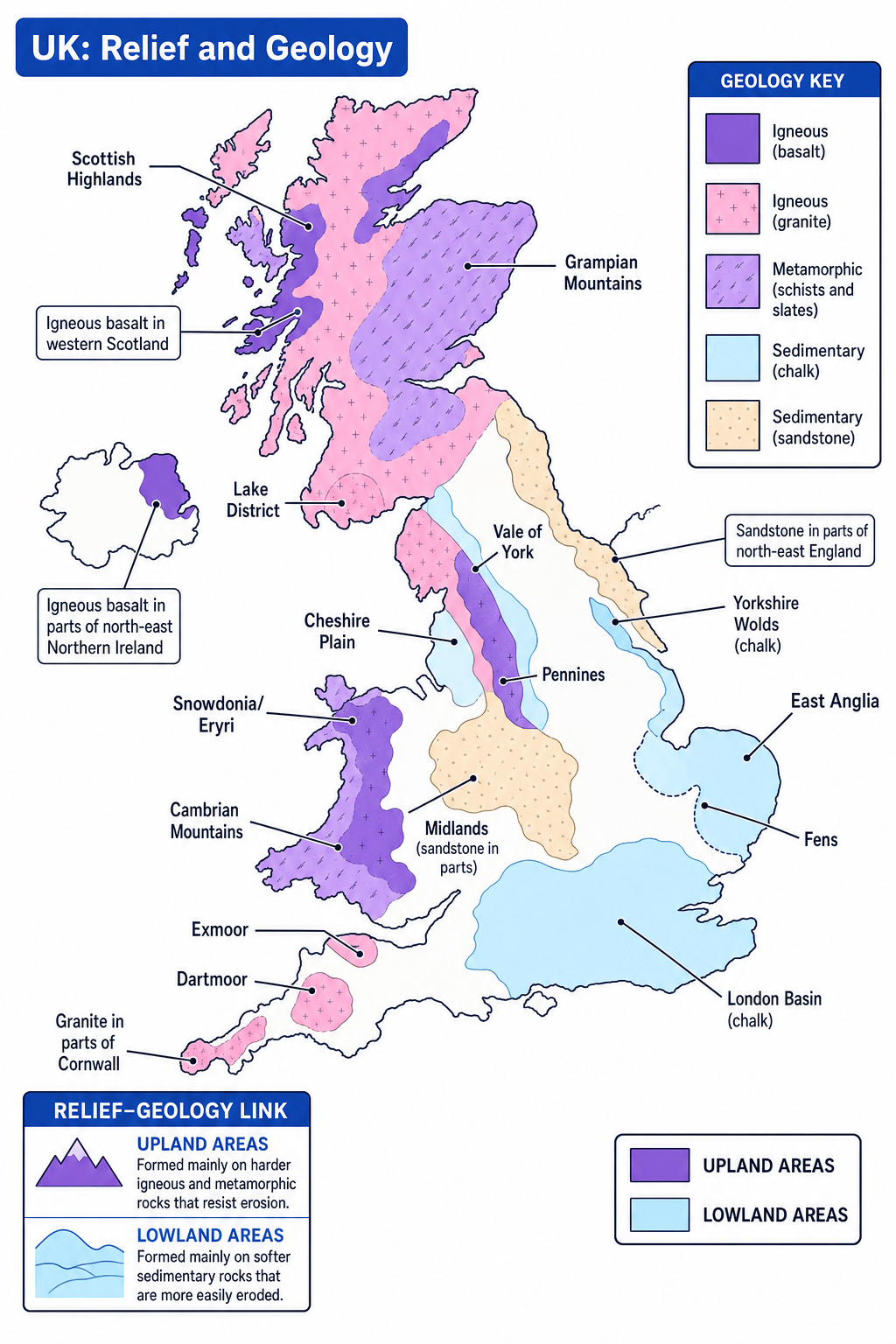
- Chalk — a soft white limestone made from microscopic marine organisms. It is found in areas such as the South Downs, North Downs, Chilterns and Yorkshire Wolds.
- Sandstone — formed from compacted sand grains. It is found in parts of the Midlands, north-east England and some upland areas such as parts of the Pennines.
Sedimentary rocks often form lowland landscapes, especially where they include softer clays and sands. However, some sedimentary rocks can still form hills and ridges if they are more resistant.
Igneous rocks
Igneous rocks form when molten rock cools and solidifies. If molten rock cools underground it forms intrusive igneous rock; if it erupts and cools at the surface it forms volcanic rock.
In the UK, examples include:
- Granite — a hard, coarse-grained rock found in places such as Dartmoor, Cornwall, the Lake District and parts of the Scottish Highlands.
- Basalt — a dark volcanic rock found in places such as north-east Northern Ireland and parts of western Scotland.
Igneous rocks are usually resistant, so they often help form rugged upland landscapes.
Metamorphic rocks
Metamorphic rocks form when existing rocks are changed by heat and pressure, often during ancient mountain-building events.
Examples include:
- Schists — common in parts of the Scottish Highlands.
- Slates — found in parts of Wales, including around Snowdonia/Eryri.
Metamorphic rocks are often hard and resistant, helping to create steep slopes, rocky summits and thin soils.
The big geology pattern
A simple UK pattern is: older, harder igneous and metamorphic rocks are more common in north and west uplands, while younger sedimentary rocks are more common in south and east lowlands.
Do not make the pattern too simple
Do not write “all uplands are igneous and all lowlands are sedimentary”. The Pennines, for example, are upland but include resistant sedimentary rocks such as sandstone and limestone.
Tectonic processes: the ancient backstory
Tectonic processes
Tectonic processes are movements and forces in the Earth’s crust, including folding, faulting, uplift and volcanic activity.
The UK is not on an active plate boundary today, but its rocks record ancient tectonic activity. In the distant past, parts of the UK were affected by mountain-building, volcanic activity and crustal movements. These processes helped create older, harder rocks and raised some areas above others.
Over millions of years, erosion wore these mountains down. Later, ice, rivers and slopes reshaped them further. This is why today’s UK landscapes are not just “made by rock type”; they are the result of rock type plus a very long history of tectonic and surface processes.
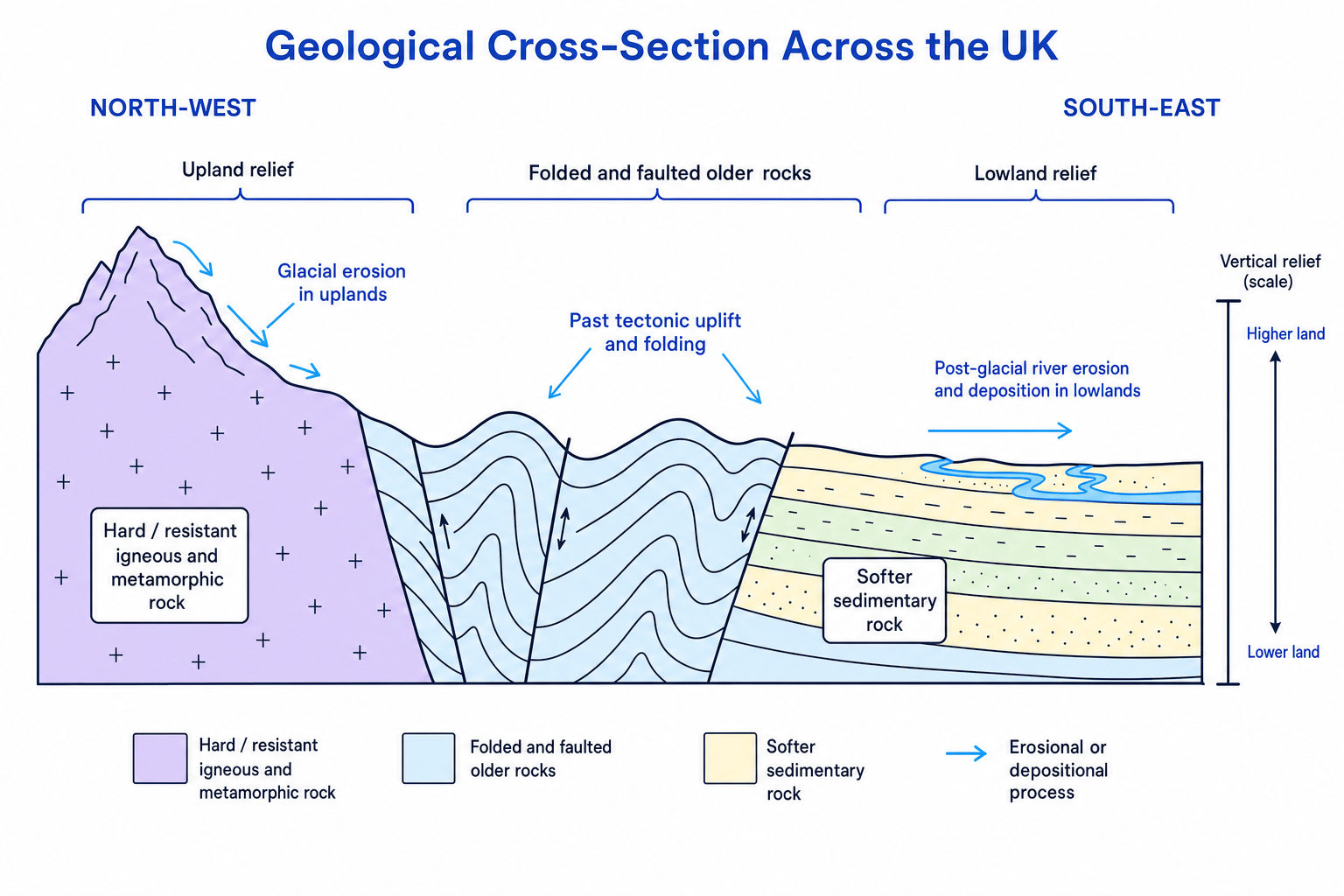
A geological cross-section is a side-view diagram showing how rock layers and relief relate to each other.
Linking rock type to relief
- Compare the rock type with the height of the land: granite or slate at high altitude suggests a resistant upland, while softer sedimentary rocks at low altitude suggest a lowland basin.
- Add the tectonic history: if the rocks have been uplifted, folded or faulted, they are more likely to stand as higher relief, especially if they are resistant.
- Add later surface processes: glacial erosion may steepen valleys in uplands, while rivers may deposit sediment across lowland floodplains.
- Form a complete explanation: the landscape is high or low because geology, tectonics and later erosion or deposition have worked together.
Physical processes that shape UK landscapes
A physical process is a natural action that changes the landscape. For this overview, the key processes are glacial erosion and deposition, weathering, climate-related processes, river processes and slope processes.
Glacial erosion and deposition
A glacier is a large mass of ice that moves slowly downhill under its own weight. During the Pleistocene ice ages, large parts of the UK were covered by ice. The last major glacial period ended around 11,700 years ago.
Glacial erosion happens when moving ice wears away rock. It can deepen valleys, steepen slopes and create dramatic upland scenery. This is important in places such as the Scottish Highlands, Lake District and Snowdonia/Eryri.
Glacial deposition happens when ice drops the material it has been carrying. This can leave deposits such as till, moraines and drumlins, shaping both upland and lowland areas.
Weathering and climate
Weathering
Weathering is the breakdown of rock where it is, without the material being transported away.
Weathering can be physical, chemical or biological. For example, freeze-thaw weathering can break apart rock in cold upland areas when water enters cracks, freezes, expands and forces the rock apart.
Climatological processes are processes linked to climate, such as rainfall, temperature and freeze-thaw conditions. The UK’s north and west are generally wetter and more exposed, which helps explain why upland landscapes often have thin soils, boggy ground and fast-flowing streams.
Weathering is not the same as erosion
Weathering breaks rock down in place. Erosion wears away and removes material, usually by rivers, waves, wind or ice.
Post-glacial river and slope processes
Post-glacial means after the last ice age. Once the ice melted, rivers adjusted to new valley shapes and large amounts of meltwater and sediment.
Rivers now continue to shape the UK by:
- eroding valleys in uplands
- transporting sediment downstream
- depositing material on floodplains in lowlands
Slope processes are movements of material downhill under gravity. These include soil creep, landslides and rockfalls. They are especially important on steep or unstable slopes.
How physical processes create distinctive landscapes
Upland landscapes often have:
- steep slopes and high relief
- thin, acidic or less fertile soils
- exposed conditions, higher rainfall and cooler temperatures
- glacial features such as corries, arêtes and U-shaped valleys in some areas
- rough grazing, moorland, reservoirs and forestry
Lowland landscapes often have:
- gentler slopes and lower relief
- deeper, more fertile soils
- wider river valleys and floodplains
- more arable farming, roads, towns and cities
- more intensive human use because the land is easier to build on and farm
Landscapes are combinations
A UK landscape usually reflects several factors working together: rock type, ancient tectonics, ice, rivers, weathering, slope movement, climate and human activity.
Human activity: people also shape the landscape
A human process is an action by people that changes places over time. In this topic, focus on agriculture, forestry and settlement.
Agriculture
Agriculture means farming. In uplands, farming is often limited by steep slopes, thin soils and harsher weather, so sheep grazing is common in areas such as the Lake District, Snowdonia/Eryri and the Scottish uplands.
In lowlands, deeper soils and flatter land allow more intensive farming, including arable farming in parts of eastern England. Drainage has also changed some landscapes, especially the Fens, where wetland has been converted into farmland.
Forestry
Forestry means planting, managing and harvesting trees. Upland areas are often used for conifer plantations because the land may be less suitable for crops or dense settlement. Kielder Forest in Northumberland is a well-known UK example.
Forestry changes the landscape visually, but it can also affect habitats, water flow and slope stability.
Settlement
Settlement means places where people live, from small villages to large cities. Lowlands usually have more settlements because flatter land is easier to build on, travel across and farm. Many UK towns and cities grew near rivers, routeways, sheltered valleys or fertile land.
Upland areas tend to be more sparsely settled because steep slopes, poorer soils and colder, wetter conditions make building and farming harder.
Using maps and OS skills
A geological map shows the distribution of rock types at the surface, often using colours or patterns. You can compare it with a relief map to see how geology links to height and slope.
An OS map is an Ordnance Survey map. At GCSE, you commonly use 1:25,000 and 1:50,000 maps. A map scale tells you how map distance relates to real distance: on a 1:50,000 map, 1 cm represents 50,000 cm, which is 500 m.
Important OS clues include:
- contours — lines joining points of equal height above sea level
- close contours — steep slopes
- widely spaced contours — gentle slopes
- blue lines — rivers or streams
- woodland symbols — forestry or natural woodland
- pink/orange built-up areas — settlements
- roads, railways and field boundaries — human geography features
Contour shortcut
Close contours mean the land height changes quickly, so the slope is steep. Wide contour spacing means height changes slowly, so the slope is gentle.
Converting an OS map distance
- Use the scale: on a 1:50,000 map, 1 cm on the map represents 500 m on the ground.
- If two points are 4 cm apart on the map, multiply by the scale distance: 4 cm×500 m per cm=2,000 m4 \text{ cm} \times 500 \text{ m per cm} = 2{,}000 \text{ m}4 cm×500 m per cm=2,000 m.
- Convert to kilometres: 2,000 m is 2 km, so the real straight-line distance is 2 km.
Recognising an upland landscape on an OS map
- Check the contour values and spacing: high contour numbers with close spacing suggest high, steep land.
- Look for drainage clues: short, fast-flowing streams in narrow valleys often suggest upland relief.
- Look for human geography clues: few settlements, minor roads, rough grazing or conifer plantations suggest land that is less suitable for dense settlement or arable farming.
- Combine the evidence: physical clues and human clues together support the judgement that the area is upland.
Where this topic leads next
This overview prepares you for the more detailed landscape topics in Edexcel GCSE Geography A. In Topic 1, your course studies two of three landscape options: coastal landscapes, river landscapes and glaciated upland landscapes. This section gives you the national “big picture” before you focus on those detailed processes and landforms.
In the exam
- Link rock type to relief, but avoid overgeneralising: mention exceptions where useful.
- Use process words accurately: weathering breaks down, erosion removes, transportation moves, deposition drops.
- When using maps, combine evidence: contours, height, rivers, rock type, woodland, roads and settlements.
Check yourself
- Why are many UK uplands found in the north and west?
- How can glacial processes and river processes both shape the same landscape?
- What OS map clues would help you identify a lowland area?