What you'll learn
- How Mumbai’s site, situation and connectivity shape its functions and structure.
- Why Mumbai has grown rapidly through natural increase, migration and investment.
- How rapid growth creates inequality, housing pressure, informal work and pollution.
- How top-down and bottom-up management can improve quality of life.
These notes use Mumbai, India as the case study city. If your school uses Lagos, Rio de Janeiro or another city, keep the same headings and swap in your own named evidence.
Emerging-country city
An emerging-country city is a major urban area in a country with rapid economic growth, increasing global links and rising incomes, but still significant inequality. Mumbai is suitable because India has a fast-growing service and manufacturing economy, while many residents still face poverty, overcrowding and poor services.
1. Mumbai’s context: site, situation and connectivity
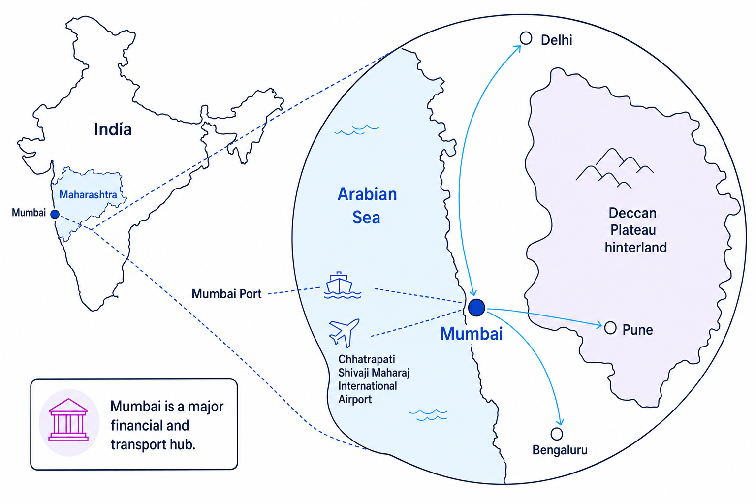
Site means the physical land the city is built on. Mumbai’s site is a low-lying coastal peninsula on India’s west coast, beside the Arabian Sea. It developed from a group of islands and reclaimed land, with a good natural harbour.
Situation means where the city is in relation to other places. Mumbai is in Maharashtra, connected to India’s western industrial region, the Deccan Plateau hinterland, and major cities such as Delhi, Pune and Bengaluru.
Connectivity means how well a place is linked by transport, trade, communication and flows of people. Mumbai has a major port, an international airport, suburban railways, national road and rail links, and digital/financial links with global businesses.
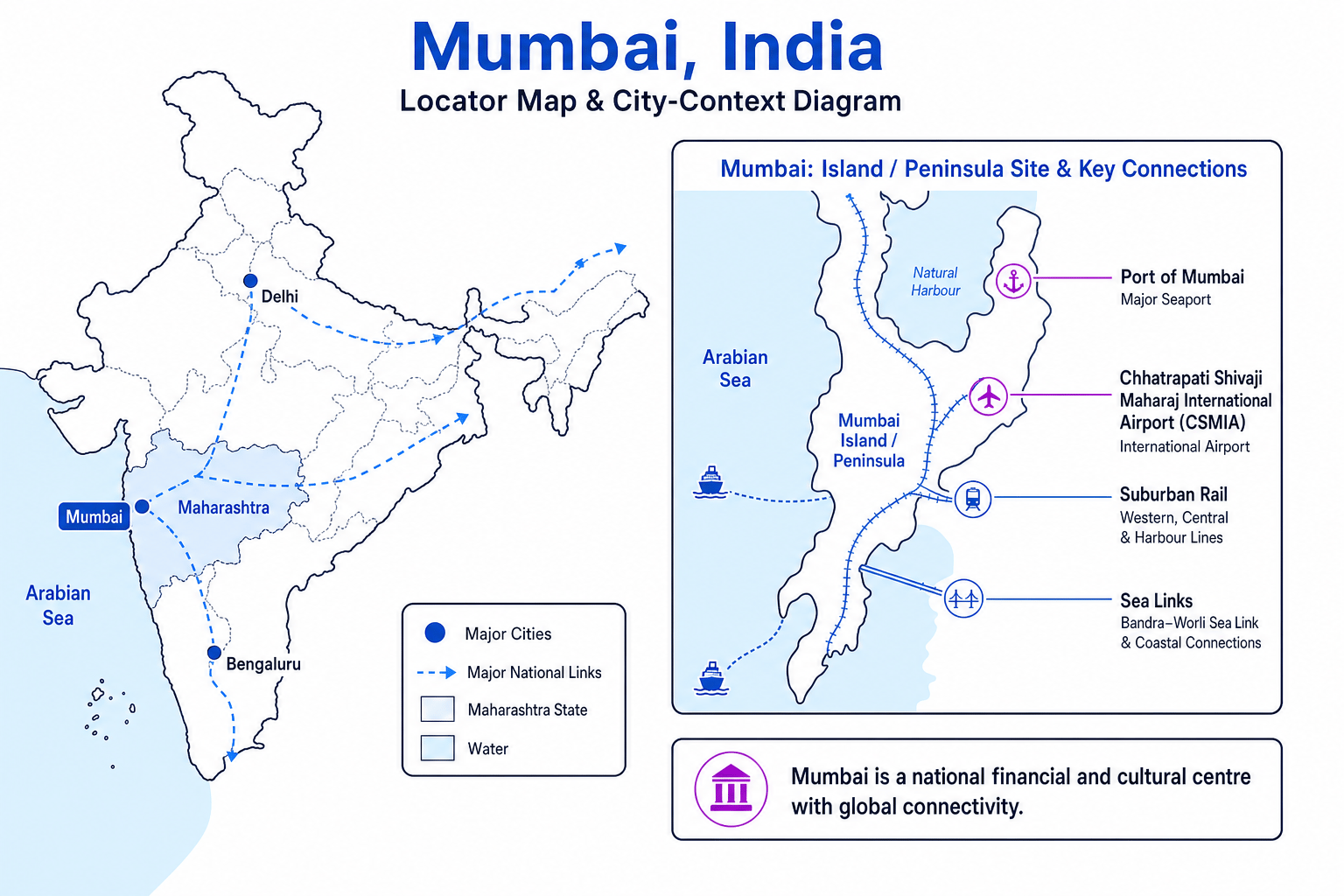
Mumbai’s context explains its main functions, which are the jobs and roles a city performs. It is India’s financial centre, home to the Bombay Stock Exchange and many company headquarters. It is also a port city, film and media centre through Bollywood, and a national transport hub.
Environmentally, the same coastal site brings risks: monsoon rainfall, storm surges, sea-level rise, flooding and pressure on mangroves and wetlands.
Context shapes function
Mumbai’s harbour and west-coast position helped it become a port, financial and cultural centre, but its low-lying reclaimed land also makes flooding and land shortage serious problems.
2. Mumbai’s urban structure
A city’s urban structure is the pattern of land use across it. In GCSE Geography, you need to describe zones such as the Central Business District, inner city, suburbs and urban-rural fringe.
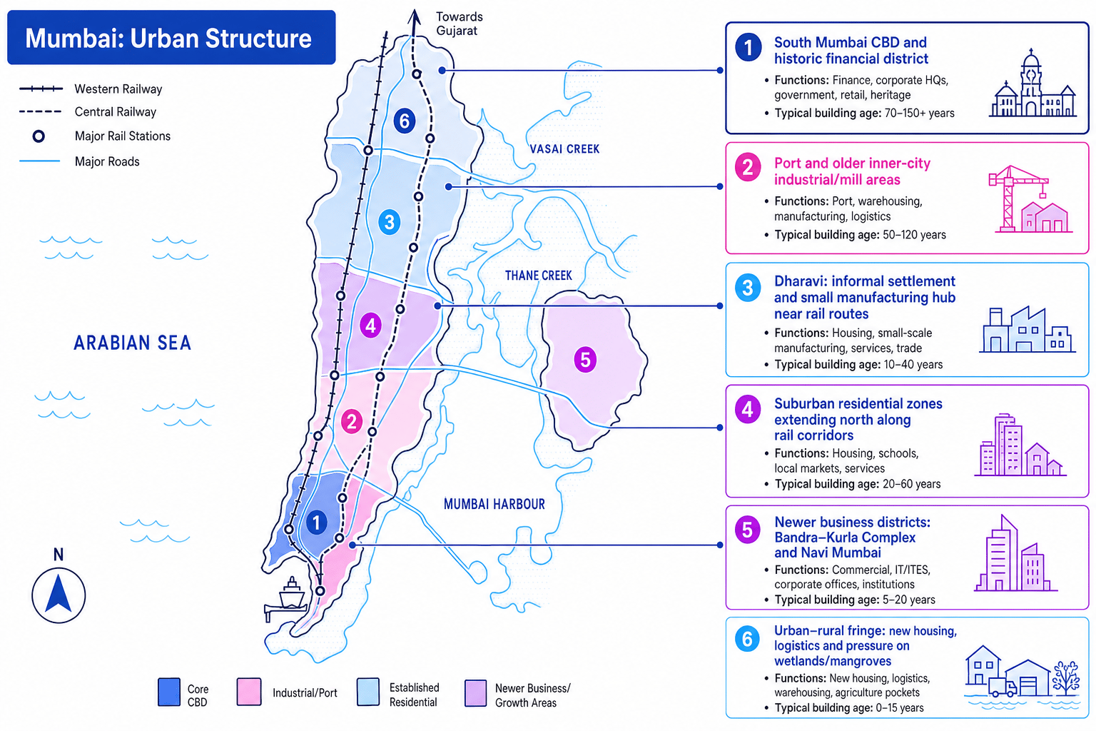
The Central Business District, or CBD, is the main commercial core, with offices, banks, shops, government buildings and transport links. In Mumbai, the historic CBD is in South Mumbai, including Fort, Nariman Point and nearby financial areas. A newer business district has developed at Bandra-Kurla Complex.
The inner city is the older zone around the CBD. In Mumbai it includes port areas, former textile mill lands, older apartment blocks and chawls, which are older tenement-style housing blocks. Some land has been redeveloped into offices and luxury flats.
An informal settlement is housing built without full legal permission or secure land ownership. Dharavi, near important rail routes, is often described as one of Asia’s largest informal settlements, but it is also a major small-scale manufacturing and recycling area.
The suburbs are mainly residential areas further from the CBD. Mumbai’s suburbs stretch north along rail corridors, including places such as Bandra, Andheri and Borivali. They contain housing, schools, markets, shopping centres and offices.
The urban-rural fringe is the edge of the built-up area where city land uses meet countryside or wetlands. Around the wider Mumbai Metropolitan Region, places such as Navi Mumbai, Thane and Kalyan-Dombivli have seen new housing, logistics, industry and transport development.
Cities are not neat rings
Do not describe Mumbai as if it perfectly follows a simple circular model. It is polycentric, meaning it has more than one important centre, including South Mumbai, Bandra-Kurla Complex and Navi Mumbai.
Using satellite imagery
- Compare the texture and shape of areas: large docks, straight quays and warehouses suggest port or industrial land, while dense tall buildings suggest a business district.
- Use transport clues: railway lines and major roads often attract suburbs, informal settlements, factories and new business parks.
- Check change over time using historic images or maps: growth into wetlands, new roads and expanding suburbs show the city spreading spatially.
3. Why Mumbai has grown rapidly
Urbanisation is the increasing proportion of people living in towns and cities. Mumbai grew quickly during the twentieth century because of its port, textile industries, rail links and later its service economy.
A natural increase happens when births exceed deaths. Mumbai’s population has included many young adults, and improved healthcare has reduced death rates, so natural increase has contributed to growth.
Migration is the movement of people from one place to another. Mumbai has attracted large-scale national migration, especially from rural areas and other Indian states such as Uttar Pradesh, Bihar, Gujarat and Tamil Nadu. Push factors include low farm incomes, drought risk, limited rural services and lack of jobs. Pull factors include construction work, domestic work, manufacturing, finance, retail, education, healthcare and family networks.
International migration is smaller than internal migration, but Mumbai’s global finance, media and business links attract some international professionals, return migrants and investors.
Economic investment has also driven growth. Since India’s economic liberalisation in the 1990s, Mumbai has attracted more private investment, financial services, real estate development, infrastructure projects and global business links.
Mixing city boundaries
Mumbai’s population depends on the boundary used: the municipal city, the urban agglomeration and the wider metropolitan region give different totals. Always say which area your data refers to if the source tells you.
Calculating decadal population growth
- Read the start and end values from the line graph. If Mumbai’s urban agglomeration is shown as 16.4 million in 2001 and 18.4 million in 2011, the time period is one decade.
- Calculate the change: 18.4−16.4=2.018.4 - 16.4 = 2.018.4−16.4=2.0 million.
- Divide by the start value and multiply by 100: 2.016.4×100≈12.2%\frac{2.0}{16.4} \times 100 \approx 12.2\%16.42.0×100≈12.2%.
- For a simple average annual percentage growth rate, divide by 10 years: 12.210≈1.2%\frac{12.2}{10} \approx 1.2\%1012.2≈1.2% per year.
4. How migration changes the city
Migration affects different parts of Mumbai in different ways.
Age structure means the proportions of people in different age groups. Migrants are often working-age adults, so some areas have a larger share of people aged around 15–39. A population pyramid, a bar chart showing age and sex, can reveal this.
Migration also affects cultural identity. Mumbai is highly diverse, with Marathi, Hindi, Gujarati, Urdu, Tamil and many other languages spoken. This creates cultural richness but can also create pressure on jobs and housing, and sometimes political tension.
Housing pressure is one of the clearest impacts. New migrants may first live with relatives, rent small rooms, move into informal settlements, or settle in older inner-city housing. Wealthier migrants and international professionals are more likely to live in high-rise apartments, gated developments or areas close to business districts.
Services are affected too. Services are facilities people use, such as schools, healthcare, water supply, sanitation and transport. Rapid migration can mean schools become overcrowded, toilets and water points are shared by many households, and trains become extremely busy.
A choropleth map uses shading to show data by area, such as population density or access to piped water. GIS, or Geographical Information Systems, is computer software that layers mapped data. For Mumbai, you might compare ward-level data on population density, informal housing, flood risk and access to services. The same skill can be used with 2011 Census output area data in UK-city questions.
5. Inequality and quality of life
Inequality means uneven access to wealth, services and opportunities. Quality of life means people’s overall wellbeing, including housing, health, income, education, safety, environment and social life.
Mumbai contains extreme wealth and poverty close together. Wealthy areas such as Malabar Hill, Cuffe Parade and parts of South Mumbai have expensive housing, private services, sea views and high-quality infrastructure. Informal settlements and some older inner-city areas may have overcrowding, insecure land tenure, shared toilets, narrow lanes and greater exposure to pollution or flooding.
However, avoid oversimplifying. Dharavi, for example, is not just “poverty”. It has strong community networks and a busy informal economy including recycling, pottery, leatherwork, food production and textiles.
Reasons for inequality include very high land prices, differences in education and skills, unequal access to formal employment, historic patterns of housing, and government or developer priorities. People with secure jobs and legal housing can access better services; people in informal work or insecure housing often have fewer choices.
Quantitative information is numerical evidence, such as income, population density or water access. Qualitative information is descriptive evidence, such as interview comments, photographs or residents’ views. You should use both to judge quality of life.
Useful skill: ecological footprint
An ecological footprint estimates the land and resources needed to support a person’s lifestyle and absorb their waste. If a source gives total footprint and population, use: footprint per person=total footprintpopulation\text{footprint per person} = \frac{\text{total footprint}}{\text{population}}footprint per person=populationtotal footprint. Wealthier areas may have higher consumption, while poorer areas may face worse local pollution.
6. Challenges from rapid urbanisation
Infrastructure means the basic systems a city needs to work, such as water pipes, sewers, electricity, roads, railways and waste collection.
Mumbai’s infrastructure is very uneven. High-income districts may have reliable piped water, electricity and private healthcare, while informal settlements may rely on shared taps, shared toilets and irregular waste collection. The suburban railway is vital but can be extremely overcrowded at peak times.
Housing is another major challenge. Formal housing is expensive because land is scarce and demand is high. This leads to overcrowding, informal settlements and redevelopment conflicts, especially where residents fear eviction or loss of livelihoods.
Under-employment means people have work, but not enough hours, income or use of their skills. Informal employment means work outside secure contracts and legal protections, such as street vending, waste picking, casual construction or home-based manufacturing. These jobs provide income but can be insecure and poorly paid.
Pollution is also severe. Traffic, construction and industry contribute to air pollution. Untreated sewage and waste can pollute rivers and creeks, including the Mithi River. Flooding becomes worse when drains are blocked and wetlands or mangroves are built over.
7. Managing Mumbai’s challenges
A top-down approach is planned by government, large organisations or developers. Examples in Mumbai include metro expansion, suburban rail upgrades, the Slum Rehabilitation Scheme, Dharavi redevelopment plans, storm-water drainage improvements and new planned areas such as Navi Mumbai.
Top-down approaches can work at a large scale and provide major funding, legal powers and city-wide infrastructure. However, they can be expensive, slow and may displace poorer residents if local voices are ignored.
A bottom-up approach is led by local communities, often with NGOs. In Mumbai, groups such as SPARC, Mahila Milan and the National Slum Dwellers Federation have supported community mapping, savings groups, toilet blocks and incremental housing improvements.
Bottom-up approaches can be cheaper, more flexible and better matched to residents’ needs. However, they may be too small to solve city-wide housing shortages, transport pressure or sewage treatment.
Government policies can improve quality of life in three main ways:
- Social: affordable housing, slum upgrading, sanitation programmes, schools and healthcare.
- Economic: transport links to jobs, skills training, formalising small businesses and supporting new business districts.
- Environmental: mangrove protection, flood management, sewage treatment, waste collection and air pollution controls.
Evaluating a management strategy
- Identify the strategy’s main aim. For example, a metro line mainly aims to improve transport capacity and reduce journey times.
- Link it to quality of life: it may improve access to jobs and reduce overcrowding, but construction can disrupt communities and fares may be too expensive for some workers.
- Make a balanced judgement by comparing scale, cost and fairness: a metro is powerful at city scale, but it works best when combined with affordable fares, walking routes, buses and protection for displaced residents.
In the exam
- Locate the city accurately: name Mumbai, India, Maharashtra, west coast, Arabian Sea, and use the correct city boundary if data is given.
- Build explanation chains: cause of growth → impact on city structure or services → effect on quality of life.
- Use evidence and judgement: quote named places, approximate figures when reliable, use maps/graphs carefully, and weigh top-down against bottom-up approaches.
Check yourself
- How do Mumbai’s site, situation and connectivity help explain both its wealth and its flood risk?
- Why does migration affect housing, services, age structure and cultural diversity in different parts of Mumbai?
- Which management approach would you prioritise for Mumbai, and what are its main limitations?