

What you'll learn
- How global atmospheric circulation creates pressure belts and surface winds.
- Why tropical storms form in some places but not others.
- How tropical storms affect people and environments, using a named example.
- How the UK experiences extreme weather, and why evidence suggests some extremes are increasing.
1. Start with weather, climate and hazards
Before you study storms, you need three basic ideas.
Weather, climate and weather hazard
Weather is the day-to-day state of the atmosphere, such as temperature, rainfall, wind and cloud. Climate is the average pattern of weather over a long period, usually about 30 years. A weather hazard is a weather event that threatens people, property, infrastructure or the environment.
A hazard becomes a bigger risk when people are exposed to it and are vulnerable. For example, a tropical storm over open ocean may cause little damage, but the same storm hitting a crowded, low-lying coastline can be disastrous.
Risk is not just the physical event
The impact of a weather hazard depends on both the strength of the event and the ability of people to prepare, cope and recover.
2. Global atmospheric circulation
Why air rises and sinks
The Sun heats the Equator more strongly than the poles because solar energy is more concentrated there. Warm air expands, becomes less dense and rises. Rising air creates low pressure. As air rises, it cools, water vapour condenses into clouds, and rainfall is more likely.
Cold air is denser and sinks. Sinking air creates high pressure. Sinking air usually warms, holds more water vapour, and gives clearer, drier conditions.
Air pressure and surface winds
Air pressure is the force caused by the weight of air pressing down on the Earth’s surface. Surface winds are winds near ground level; they generally move from high pressure towards low pressure, but they are deflected by the Coriolis effect, the apparent bending caused by the Earth’s rotation.
The three-cell circulation model
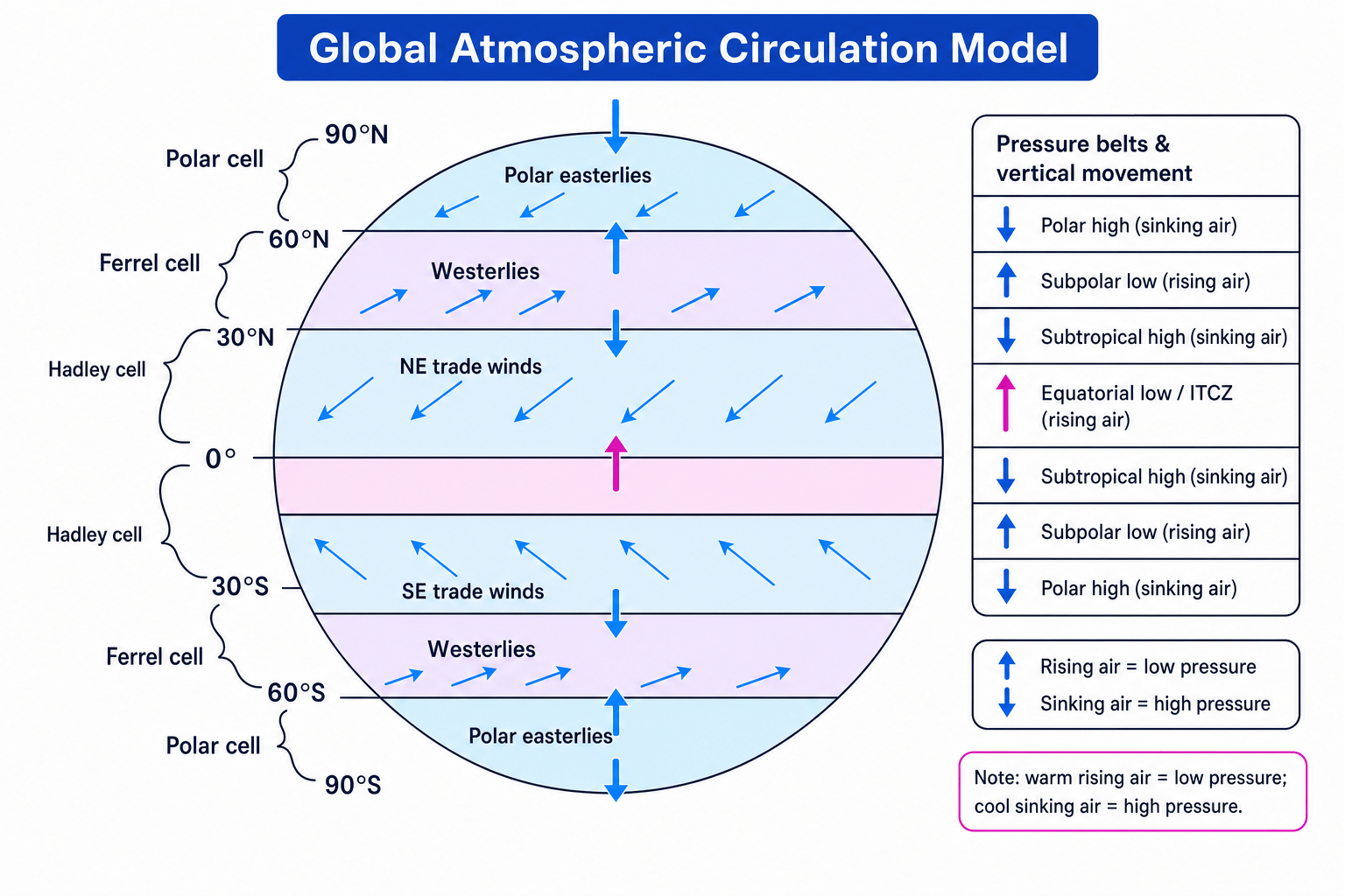
The general atmospheric circulation model is a simplified model showing how air moves around the planet. Each hemisphere has three main circulation cells:
- Hadley cell: 0° to 30°, with rising air near the Equator and sinking air around 30°.
- Ferrel cell: 30° to 60°, linked to the westerly winds and unsettled mid-latitude weather.
- Polar cell: 60° to 90°, with cold sinking air near the poles.
Use the diagram to connect cells, pressure belts and surface wind belts.
| Latitude zone | Pressure belt | Usual weather or climate link |
|---|---|---|
| Equator, 0° | Equatorial low, also called the ITCZ | Warm rising air, cloud and heavy rainfall |
| Around 30° north and south | Subtropical high | Sinking air, dry climates and many deserts |
| Around 60° north and south | Subpolar low | Rising air, cloudier and wetter conditions |
| Poles, 90° north and south | Polar high | Cold sinking air, dry conditions |
The main surface wind belts are the trade winds, westerlies and polar easterlies. These winds help move heat and moisture around the world, and they also help steer weather systems.
Explaining a dry belt at 30° north
Why are many deserts found near 30° north?
- Air rises at the Equator because it is strongly heated, creating low pressure and heavy rainfall there.
- High in the atmosphere, some of this air moves polewards as part of the Hadley cell.
- By about 30° north, the air sinks, creating high pressure; sinking air warms and makes cloud formation less likely.
- The result is dry, stable conditions, which helps explain deserts such as the Sahara.
3. Tropical storms
What tropical storms are
Tropical storm
A tropical storm is an intense low-pressure storm that develops over warm tropical oceans. When sustained wind speeds reach about 119 km/h, it may be called a hurricane in the Atlantic and north-east Pacific, a typhoon in the north-west Pacific, or a cyclone in the Indian Ocean and South Pacific.
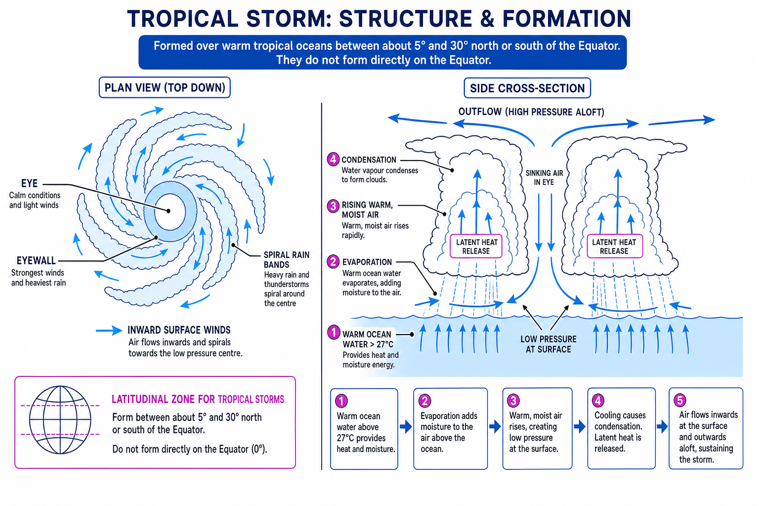
Tropical storms are not randomly spread across the world. They usually form between about 5° and 30° north and south of the Equator, over warm tropical oceans. They do not form directly on the Equator because the Coriolis effect is too weak there to make the storm spin.
They are linked to global atmospheric circulation because they form near warm, low-pressure tropical zones where air rises and converges. Trade winds often steer them westwards before they curve towards higher latitudes.
Where tropical storms form
Tropical storms form where several conditions overlap: warm ocean water, rising moist air, low pressure, enough Coriolis spin, and low vertical wind shear.
Conditions needed for formation
Tropical storms need:
- Sea surface temperatures of about 27°C or more.
- Warm water to a reasonable depth, so the storm is not quickly “starved” of energy.
- Lots of evaporation to supply moist air.
- A pre-existing low-pressure disturbance.
- Enough Coriolis effect, usually at least 5° away from the Equator.
- Low vertical wind shear, meaning winds do not change too much with height. Strong wind shear can tear a storm apart.
The formation sequence is usually:
- Warm ocean water causes rapid evaporation.
- Warm, moist air rises, creating low pressure at the surface.
- Air rushes in towards the low pressure and begins to spin due to the Coriolis effect.
- Rising air cools and condenses, releasing latent heat, which is stored heat released during condensation.
- The extra heat makes air rise faster, deepening the low pressure and strengthening the storm.
- The storm weakens when it moves over land, cooler water, or into strong wind shear.
These stages produce the structure you need to recognise and label.
Checking whether a tropical storm can develop
A tropical disturbance is over 29°C ocean water at 12°N, with low wind shear, but it is forecast to cross land tomorrow.
- The latitude, 12°N, is far enough from the Equator for the Coriolis effect to create spin.
- The sea temperature is above 27°C, so evaporation and latent heat release can provide energy.
- Low wind shear means the storm structure is less likely to be torn apart.
- However, crossing land tomorrow will cut off the warm ocean energy supply, so the storm may strengthen briefly but should then weaken.
Structure and features
The eye is the calm centre of the storm, where air sinks. The eyewall surrounds the eye and has the strongest winds and heaviest rainfall. Spiral rain bands are curved bands of cloud and rain extending out from the centre.
A dangerous coastal feature is a storm surge: a temporary rise in sea level caused by low pressure and strong winds pushing seawater towards the coast.
Climate change and tropical storms
Climate change may affect tropical storms, but the pattern is not simple. Warmer oceans can provide more energy, so the strongest storms may become more intense. A warmer atmosphere can hold more water vapour, so rainfall rates may increase. Sea-level rise can make storm surges more damaging.
Some storms may form or travel slightly further polewards as ocean temperatures rise, but global frequency is uncertain. Many scientists expect fewer or similar numbers overall, but a higher proportion of very intense storms.
Climate change wording
Avoid writing “climate change causes tropical storms.” A better answer is: climate change may increase the intensity, rainfall and coastal flood impacts of some tropical storms, but evidence for frequency is less certain.
4. Tropical storm effects and responses
Effects and responses
A primary effect happens directly because of the storm, such as buildings being destroyed by wind. A secondary effect happens later or indirectly, such as disease spreading after water supplies are contaminated. An immediate response happens during or just after the event, while a long-term response helps recovery and reduces future risk.
Named example: Typhoon Haiyan, Philippines, 2013
Typhoon Haiyan, locally called Yolanda, hit the Philippines in November 2013. It was one of the strongest tropical cyclones ever recorded at landfall, affecting areas including Leyte and Tacloban. Exact figures vary by source, but the scale is clear.
| Category | Details |
|---|---|
| Primary effects | Over 6,000 deaths; many injuries; storm surge around 5 metres in places; homes, roads, power lines and airports damaged; fishing boats and crops destroyed. |
| Secondary effects | Millions displaced; shortages of clean water, food and shelter; livelihoods damaged, especially farming and fishing; disease risk increased due to contaminated water. |
| Immediate responses | Warnings and evacuations before landfall; search and rescue; emergency shelters; food, water and medical aid from the Philippines government and international agencies. |
| Long-term responses | Homes and infrastructure rebuilt; “Build Back Better” programmes; coastal no-build zones proposed; livelihoods supported through aid, cash-for-work and replacement fishing boats. |
Sorting impacts and responses after Haiyan
Classify these four statements: storm surge destroyed homes; contaminated water increased disease risk; emergency food parcels were delivered; homes were rebuilt using stronger designs.
- “Storm surge destroyed homes” is a primary effect because it was direct physical damage caused by the storm.
- “Contaminated water increased disease risk” is a secondary effect because it happened indirectly after flooding damaged water supplies.
- “Emergency food parcels were delivered” is an immediate response because it met urgent survival needs soon after the storm.
- “Homes were rebuilt using stronger designs” is a long-term response because it supported recovery and reduced future vulnerability.
Reducing the effects of tropical storms
You cannot stop a tropical storm, but you can reduce risk.
| Method | What it means | Examples |
|---|---|---|
| Monitoring | Collecting data about the storm | Satellites, radar, ocean buoys, aircraft, weather stations |
| Prediction | Forecasting track, intensity and landfall | Computer models, forecast cones, warning systems |
| Protection | Physical measures to reduce damage | Sea walls, storm shelters, flood barriers, stronger buildings, mangrove restoration |
| Planning | Organising people before the hazard | Evacuation routes, drills, emergency supplies, land-use zoning |
5. Weather hazards in the UK
The UK is not in the tropics, so it does not get true tropical storms. However, it does experience several weather hazards because it lies in the mid-latitudes, where different air masses meet and Atlantic low-pressure systems often arrive.
Main UK weather hazards include:
- Heavy rainfall and river flooding.
- Coastal flooding and storm surges.
- Strong winds from Atlantic storms.
- Snow, ice and cold spells.
- Heatwaves and drought.
- Thunderstorms, hail and lightning.
- Fog, which can disrupt transport.
A depression is a low-pressure system often bringing cloud, rain and strong winds. An anticyclone is a high-pressure system; in summer it can bring heatwaves, while in winter it can bring fog, frost or very cold conditions.
6. Recent UK extreme weather: July 2022 heatwave
Extreme weather
Extreme weather is weather that is unusual for a place and time of year, especially if it breaks records or causes major disruption.
In July 2022, the UK recorded 40.3°C at Coningsby, Lincolnshire — the first time the UK officially exceeded 40°C.
| Aspect | July 2022 heatwave |
|---|---|
| Causes | High pressure brought clear skies and sinking air; hot air moved north from western Europe and North Africa; dry ground helped temperatures rise further; climate change made this level of heat more likely. |
| Social impacts | Health risks increased, especially for elderly and vulnerable people; schools, hospitals and care homes had to manage heat stress; homes were evacuated where wildfires spread. |
| Economic impacts | Rail services were cancelled or slowed because tracks could buckle; roads and runways were affected in places; farmers faced crop and livestock stress; water demand increased. |
| Environmental impacts | Wildfires damaged grassland, woodland and homes, including in parts of London; rivers and soils became drier; wildlife faced heat and water stress. |
| Management | Met Office red extreme heat warnings; public health alerts; advice to stay cool and hydrated; checks on vulnerable people; fire service preparation; transport speed restrictions; longer-term plans such as urban greening and heat-resilient infrastructure. |
Linking heatwave management to risk reduction
How can management reduce the risk from extreme heat on railways?
- Extreme heat can cause metal rails to expand and buckle, increasing the risk of accidents.
- Speed restrictions reduce stress on the track and lower accident risk, but they also cause delays and economic disruption.
- Longer-term adaptation, such as more heat-resistant track design and better maintenance, reduces vulnerability in future heatwaves.
7. Is UK weather becoming more extreme?
There is growing evidence that some UK weather extremes are becoming more common or more severe.
Important evidence includes:
- Temperature records: the UK’s warmest years have mostly occurred in the 21st century, and 2022 broke the 40°C threshold.
- Rainfall extremes: warmer air can hold more water vapour, increasing the chance of intense downpours, although patterns vary by region and season.
- Sea-level rise: higher sea levels increase the risk of coastal flooding during storms.
- Climate projections: the UK is expected to have warmer, wetter winters, hotter, drier summers, and more intense rainfall events.
One event is not proof
Do not say one heatwave or flood “proves” climate change. Stronger answers use long-term trends, records and projections, then explain that climate change changes the probability and severity of extreme events.
In the exam
- For global circulation, link heating → rising or sinking air → pressure → wind or rainfall pattern.
- For tropical storms, always connect conditions, formation sequence, structure, effects and responses.
- For case studies and examples, use place names and approximate figures, but focus on explaining why impacts happened and how management reduced risk.
Check yourself
- Why do tropical storms form between about 5° and 30° north and south, but not directly on the Equator?
- What is the difference between a primary effect and a secondary effect of Typhoon Haiyan?
- What evidence suggests that some UK weather is becoming more extreme?
