What you'll learn
- Where ice covered the UK during the last ice age.
- How glaciers weather, erode, transport and deposit material.
- How to recognise and explain major glacial landforms.
- How glaciated upland areas are used today, especially for tourism, and how conflicts are managed.
Big picture: why glaciation matters in the UK
If your school has chosen Glacial landscapes in the UK as one of your Physical landscapes options, you need to understand both the physical processes and the human uses of glaciated uplands.
Glacier
A glacier is a large mass of ice that forms on land when snow builds up, is compressed into ice, and starts to move downhill under gravity.
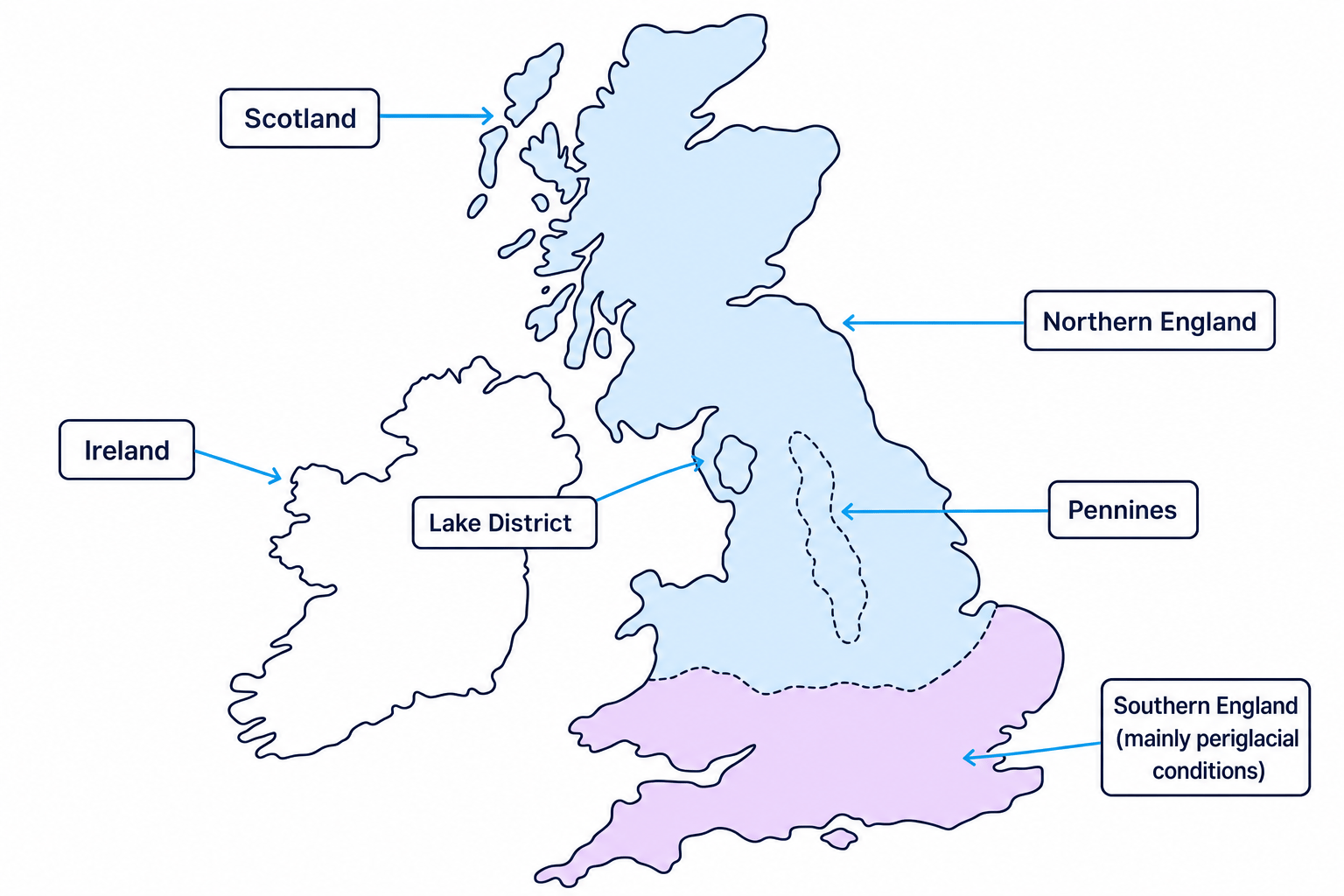
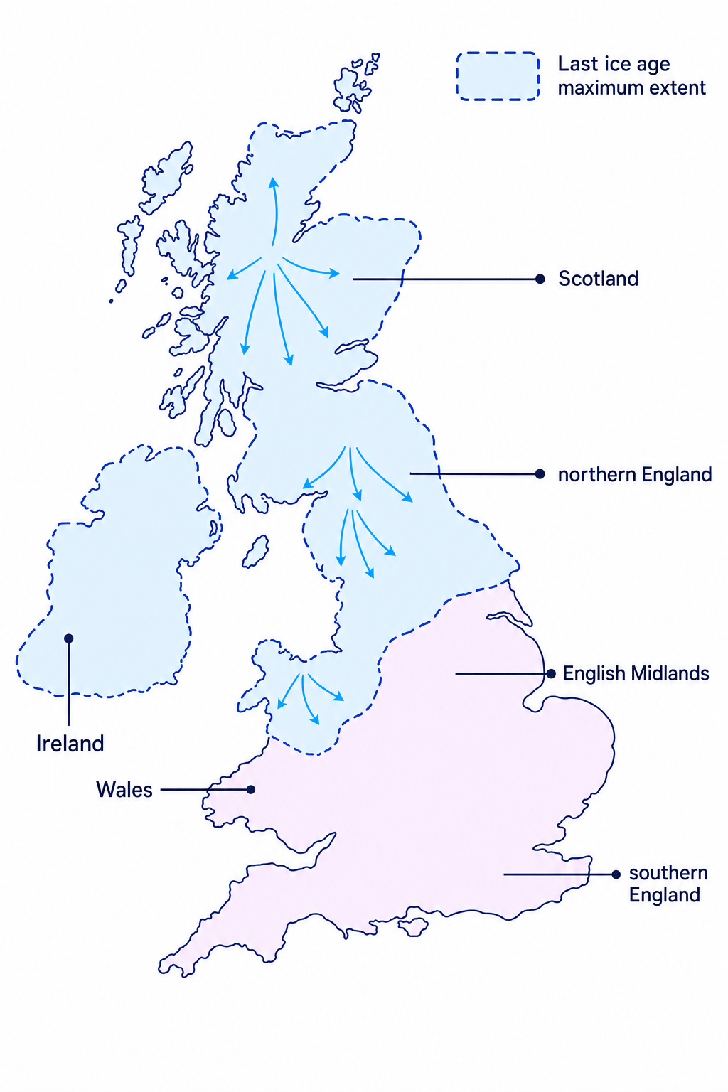
During the last ice age — often called the Devensian in Britain — ice reached its maximum extent around 20,000 years ago. Ice covered all of Scotland, much of Wales, northern England, upland areas such as the Lake District and Pennines, and Ireland. Southern England was mostly not covered by ice, but it was still very cold, with periglacial conditions: cold, icy ground near but not under an ice sheet.
Ice as a landscape shaper
Glaciers are powerful because they are heavy, moving bodies of ice. They can break up rock, scrape valley floors, carry huge loads of debris, and leave sediment behind when they melt.
How glaciers change landscapes
Freeze-thaw weathering
Freeze-thaw weathering
Freeze-thaw weathering is the breakdown of rock when water enters cracks, freezes and expands, then thaws and contracts repeatedly.
This is common in upland glacial areas because temperatures often move above and below freezing. Over time, cracks widen and pieces of rock break off. This provides loose material for glaciers to pick up and transport.
Erosion: abrasion and plucking
Glacial erosion
Erosion is the wearing away and removal of rock. In glaciated landscapes, the two key erosion processes are abrasion and plucking.
Abrasion happens when rocks frozen into the base and sides of a glacier scrape against the valley floor and walls. Think of it like coarse sandpaper grinding over rock.
Plucking happens when meltwater enters cracks in rock, freezes onto the rock, and the moving glacier pulls pieces away. This is especially effective on steep back walls and valley sides.
Movement and transportation
Glaciers move mainly because of gravity. Ice may deform internally, slide over wet bedrock, or move in a curved way called rotational slip.
Rotational slip
Rotational slip is the curved movement of ice, especially in a corrie, where the ice rotates downhill and helps erode a deep hollow.
Glaciers transport material of many sizes, from fine clay to huge boulders. Some debris is carried on top of the ice, some inside it, and some at the base.
Bulldozing happens when the moving glacier pushes loose material in front of it, especially near the glacier snout, which is the lower end of the glacier.
Deposition: till and outwash
Deposition
Deposition is the dropping of material that was being transported.
Glaciers deposit sediment when they lose energy, melt, or can no longer carry their load. Ice directly deposits till, which is unsorted material containing a mix of clay, sand, gravel and boulders. Meltwater streams deposit outwash, usually sorted sand and gravel, because flowing water separates particles by size.
Explaining deposition at a glacier snout
- The glacier snout is usually at a lower, warmer altitude, so melting is greater than accumulation and the ice can no longer carry as much debris.
- Material released directly from the melting ice is deposited as unsorted till, often building features such as moraine.
- Meltwater streams carry finer material away from the snout; when their velocity falls, they deposit sorted sand and gravel as outwash.
Till and outwash are not the same
Till is deposited directly by ice and is unsorted. Outwash is deposited by meltwater and is more sorted because water separates particles by size.
Landforms created by glacial erosion
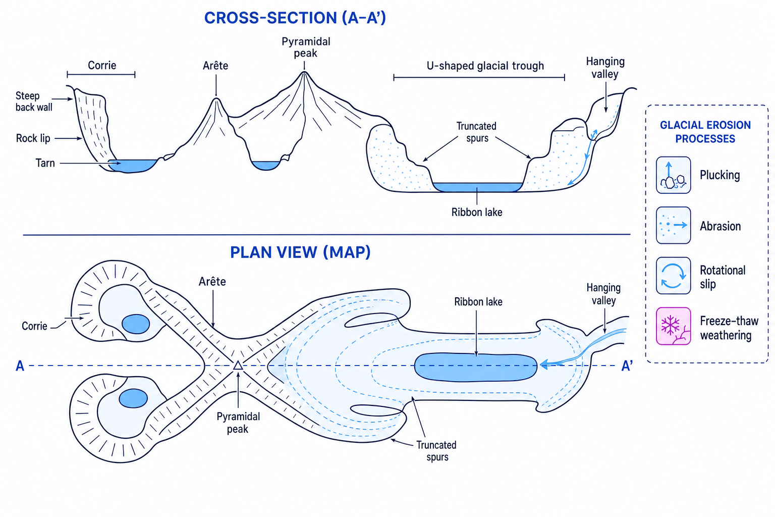
Glacial erosion creates some of the most distinctive upland landforms in the UK. The diagram below brings together the main erosion landforms you need for AQA.
Corries
Corrie
A corrie is an armchair-shaped hollow on a mountainside, with a steep back wall, steep sides, a rock lip, and often a small lake called a tarn.
Corries begin as snow-filled hollows. Snow compacts into ice, then rotational slip moves the ice in a curved motion. Freeze-thaw weathering breaks up rock around the hollow. Plucking steepens the back wall, and abrasion deepens the basin. When the glacier melts, water may collect behind the rock lip to form a tarn.
Arêtes and pyramidal peaks
An arête is a narrow, knife-edge ridge formed when two corries erode back-to-back, or when two glaciated valleys erode on either side of a ridge.
A pyramidal peak is a sharp mountain peak formed when three or more corries erode backwards into the same mountain. The remaining rock is steep and pointed.
Glacial troughs, truncated spurs and ribbon lakes
Glacial trough
A glacial trough is a U-shaped valley with steep sides and a wide, flat floor, formed when a glacier deepens and widens an earlier river valley.
Before glaciation, rivers often create V-shaped valleys with interlocking spurs. A glacier is much wider and more powerful than a river. It cuts through those spurs, leaving steep valley sides called truncated spurs.
A ribbon lake is a long, narrow lake found on the floor of a glacial trough. It may form where a glacier overdeepened softer rock, or where moraine blocks drainage after the ice melts.
Hanging valleys
A hanging valley is a smaller tributary valley left high above the main glacial trough. The main glacier erodes more deeply than the smaller side glacier, so after melting, the tributary valley appears to “hang” above the main valley. Waterfalls often form where streams drop from the hanging valley into the main trough.
Identifying erosion landforms from evidence
- If a photo shows a steep, armchair-shaped hollow with a small lake and a rock lip, the best match is a corrie with a tarn.
- If the same landscape also has a narrow ridge between two hollows, that ridge is likely to be an arête because erosion has attacked it from both sides.
- If a valley has a wide flat floor, steep sides and cut-off spurs, it is more likely to be a glacial trough than a river valley.
U-shaped does not mean any wide valley
A glacial trough should have evidence of glacial erosion, such as steep sides, a broad flat floor, truncated spurs, ribbon lakes or hanging valleys. Do not just write “wide valley” and stop.
Landforms created by transportation and deposition
Glaciers carry and deposit material in ways that create very different landforms from erosion. The key is to ask: was the material dropped directly by ice, shaped under moving ice, or laid down by meltwater?
Moraine
Moraine
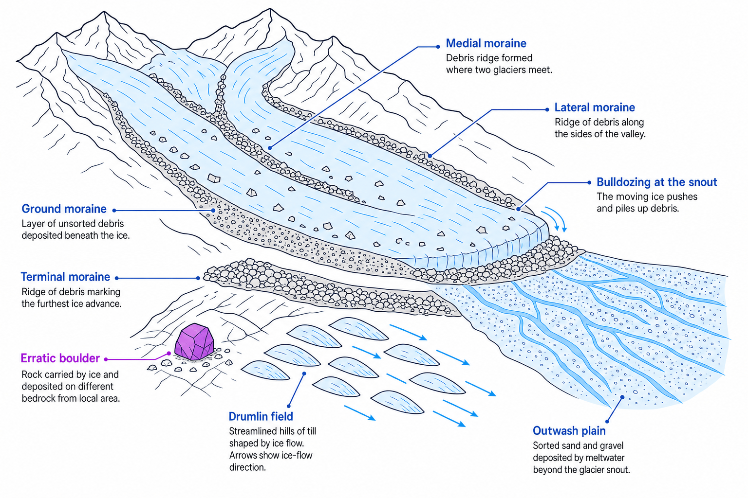
Moraine is a ridge or mound of till deposited by a glacier.
The main types are:
- Lateral moraine: debris deposited along the sides of a glacier.
- Medial moraine: debris running down the middle of a glacier where two glaciers join.
- Terminal moraine: a ridge of debris marking the furthest advance of a glacier.
- Ground moraine: a layer of till deposited beneath the ice.
- Recessional moraine: ridges left as a glacier pauses during retreat.
Erratics
An erratic is a boulder transported by ice and deposited on bedrock that is different from the rock type of the boulder. Erratics are useful evidence of past ice movement because they show material has been carried from somewhere else.
Drumlins
A drumlin is a smooth, elongated hill made of till. Drumlins often occur in groups called swarms. They usually have a steeper blunt end facing up-ice and a gentler tapered end pointing down-ice, so they can indicate the direction of former ice movement.
Sorted or unsorted?
If material is mixed up, angular and different sizes, think till or moraine. If it is sorted into sands and gravels, think meltwater outwash.
Example upland area affected by glaciation: the Lake District
The specification asks for an example, not a full case study, of a UK upland area affected by glaciation. A strong choice is the Lake District, Cumbria, in north-west England.
Lake District, Cumbria
Use place-specific landforms: Red Tarn is a corrie below Helvellyn; Striding Edge and Swirral Edge are arêtes; valleys such as Borrowdale and Great Langdale show U-shaped glacial troughs; lakes such as Windermere and Ullswater are ribbon lakes. Deposition features include moraines, erratics and drumlins in lower areas such as around Kendal and the Eden Valley.
Economic activities in glaciated upland areas
Glaciated uplands are not just physical landscapes; people use them in different ways.
Tourism
Tourists are attracted by dramatic scenery, mountains, lakes, walking routes, climbing, watersports and historic villages. In the Lake District, places such as Keswick, Ambleside, Bowness-on-Windermere, Helvellyn and Scafell Pike attract large numbers of visitors.
Farming
Upland areas often have thin soils, steep slopes and a cool, wet climate, so farming is usually extensive rather than intensive. Sheep farming is common because sheep can graze rough upland pasture.
Forestry
Steep slopes and poorer soils may be used for commercial forestry, especially conifer plantations. Forestry provides timber and jobs, but it can change habitats and reduce the natural appearance of the landscape.
Quarrying
Glaciated uplands often contain valuable rock, such as slate, granite or limestone. Quarrying provides materials and employment, but it can create scars in the landscape, noise, dust and lorry traffic.
Conflicts and management
A land use conflict happens when different groups want to use the same place in different ways. In glaciated uplands, conflicts often happen between development and conservation, which means protecting and carefully managing the environment.
Common conflicts include:
- Tourists want access, parking and facilities, but conservationists want to protect footpaths, habitats and quiet areas.
- Farmers may be affected by walkers leaving gates open, dogs worrying sheep, or cars blocking narrow lanes.
- Quarry companies provide jobs and building materials, but local people may object to noise, dust, traffic and visual damage.
- Forestry can support the economy, but plantations may reduce biodiversity or affect views.
Explaining a land-use conflict
- Identify the two groups using the same place, such as tourists using a mountain path and conservationists trying to protect fragile upland vegetation.
- Explain the impact of one use on the other: heavy footfall removes vegetation, exposes soil and increases erosion, which damages the landscape tourists came to enjoy.
- Link a management strategy to the problem: stone pitching, drainage and marked routes concentrate walkers on a durable path and reduce wider trampling.
Tourism example: Lake District National Park
The Lake District is a strong UK example of a glaciated upland area used for tourism. It receives many millions of visits each year — often quoted at around 18–20 million, depending on the year and data source.
Attractions for tourists
Tourists visit for:
- Mountains such as Scafell Pike and Helvellyn.
- Lakes such as Windermere, Ullswater and Derwentwater.
- Glacial scenery including corries, arêtes, trough valleys and ribbon lakes.
- Walking, climbing, cycling, boating and photography.
- Honeypot settlements such as Keswick, Ambleside and Bowness-on-Windermere.
Honeypot site
A honeypot site is a place that attracts a very large number of visitors, often causing pressure on roads, paths, services and the environment.
Impacts of tourism
Tourism brings economic benefits: jobs in hotels, cafés, shops, outdoor activity companies and transport; income for local businesses; and support for services that local residents also use.
There are also social impacts. Tourism can create traffic congestion, crowded villages, pressure on parking, and rising house prices, especially where second homes and holiday lets reduce housing availability for local people.
Environmental impacts include footpath erosion, litter, disturbance to wildlife, water pollution from boats or busy settlements, and visual pressure from car parks or visitor facilities.
Management strategies
The Lake District uses a range of strategies to reduce tourism impacts:
- Footpath repair, such as stone pitching and drainage through projects like Fix the Fells.
- Traffic management, including car parks, buses, boats and encouragement of cycling and walking.
- Planning controls by the National Park Authority to manage new development.
- Visitor education, including signs, ranger advice and countryside codes.
- Zoning, where more intensive tourism is encouraged in some areas while quieter or fragile areas are protected.
Sustainable tourism
Good management does not try to stop tourism completely. It aims to keep the economic benefits while reducing damage to landscapes, ecosystems and local communities.
In the exam
- For landform formation, write a sequence: starting feature, process, then final landform characteristics.
- Use named places for examples: “Lake District” is good, but “Red Tarn corrie” or “Striding Edge arête” is much stronger.
- For tourism questions, cover social, economic and environmental impacts, then link each management strategy to the impact it reduces.
Check yourself
- How do freeze-thaw weathering, plucking, abrasion and rotational slip work together to form a corrie?
- What evidence would help you tell a glacial trough apart from a river valley?
- For your tourism example, can you name one attraction, one impact and one management strategy?