What you'll learn
- How a river valley changes from the source to the mouth.
- How erosion, transportation and deposition create river landforms.
- How hydrographs show the link between rainfall and river discharge.
- How UK flood management schemes balance protection, cost and environmental impact.
In AQA Physical landscapes in the UK, your class studies UK landscapes plus two from coasts, rivers and glacial landscapes. These notes are for the River landscapes option.
1. River systems: the basic language
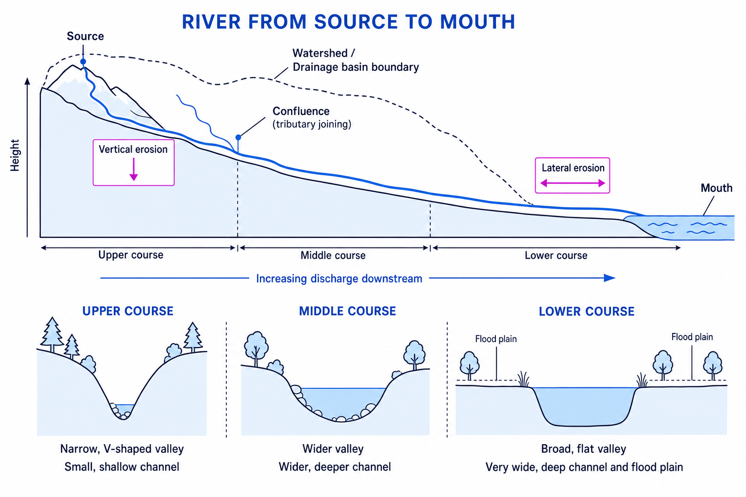
A river is water flowing in a natural channel — the river bed and banks. The source is where the river begins, often in upland areas. The mouth is where it ends, usually at the sea.
A tributary is a smaller river that joins a larger river. The joining point is a confluence. A drainage basin is the area of land drained by a river and its tributaries. The edge of a drainage basin is the watershed, usually high land.
2. How river valleys change downstream
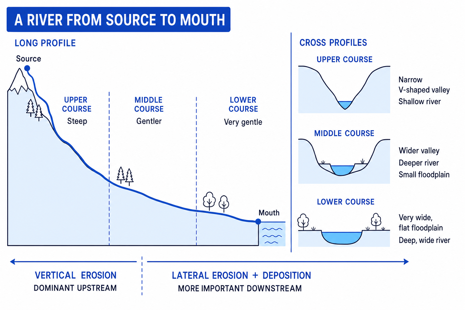
A river’s long profile is the side view of the river from source to mouth. It is usually steep in the upper course and gentler towards the lower course.
A cross profile is the shape of the river valley and channel if you sliced across it. This changes from a narrow, V-shaped valley upstream to a wide, flat valley downstream.
Downstream pattern
From source to mouth, rivers generally become wider, deeper and flow through flatter, wider valleys. The dominant erosion changes from vertical erosion downwards to more lateral erosion sideways.
Vertical erosion means the river cuts down into its bed. Lateral erosion means the river erodes sideways into its banks. Downstream, the river usually has more discharge — the volume of water passing a point each second — because tributaries add water.
Explaining downstream valley change
- In the upper course, the gradient is steep, so the river has enough energy to cut down into its bed. This vertical erosion creates a narrow, V-shaped valley.
- Further downstream, tributaries increase discharge, so the channel becomes wider and deeper.
- As the gradient becomes gentler, the river has more sideways movement. Lateral erosion and deposition widen the valley and help form a flood plain.
3. Fluvial processes
Fluvial processes are processes carried out by rivers. The three big ones are erosion, transportation and deposition.
Erosion
Erosion is the wearing away of the bed and banks of a river.
- Hydraulic action: the force of water hits the bed and banks, forcing air into cracks and breaking rock apart.
- Abrasion: rocks carried by the river scrape and grind against the bed and banks.
- Attrition: rocks carried by the river knock into each other, becoming smaller, smoother and rounder.
- Solution: some rocks, especially limestone and chalk, dissolve in slightly acidic river water.
Solution has two meanings
Solution can be an erosion process, where rock dissolves, and a transportation process, where dissolved minerals are carried in the water. Use the context carefully.
Transportation
Transportation is the movement of sediment, which means rock material carried by the river. The sediment is also called the river’s load.
- Traction: large rocks roll along the river bed.
- Saltation: small pebbles bounce along the bed.
- Suspension: fine material is carried within the water.
- Solution: dissolved minerals are carried in the water.
Deposition
Deposition happens when a river drops its load. This occurs when the river loses energy, for example when discharge falls after a flood, the gradient becomes gentler, the river enters the sea, or water slows on the inside of a bend.
4. Landforms created by rivers
Interlocking spurs
In the upper course, a river often cannot cut through hard rock hillsides. Instead, it winds around ridges of land. These ridges are interlocking spurs — alternating projections of high land in a V-shaped valley.
Waterfalls and gorges
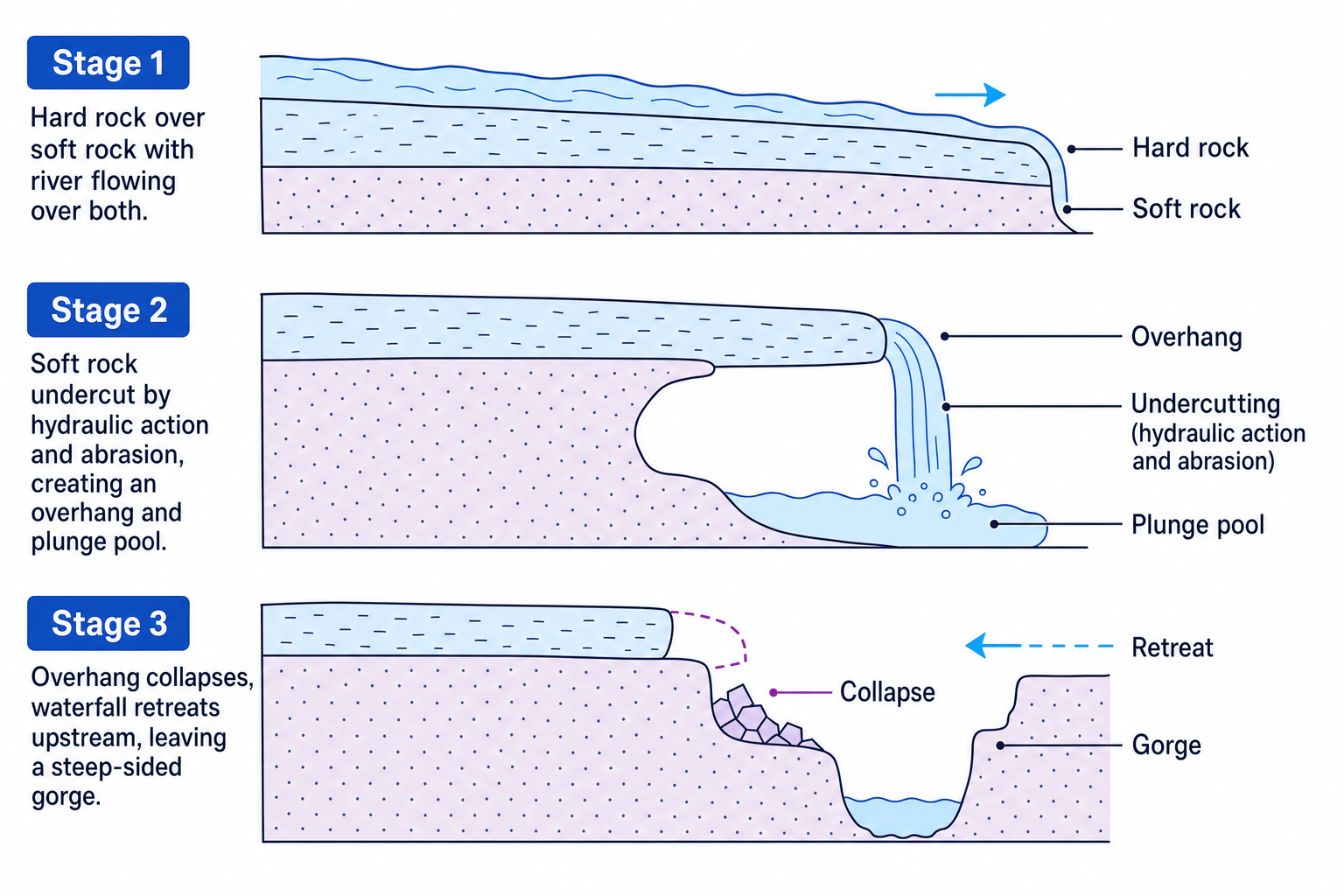
A waterfall is a sudden drop in the river’s course. It often forms where a band of hard rock lies over softer rock. A gorge is a steep-sided valley left behind as a waterfall retreats upstream.
Explaining waterfall retreat
- The river flows over hard rock on top of softer rock. The softer rock is less resistant, so it erodes more quickly.
- Hydraulic action and abrasion undercut the softer rock, creating an overhang of hard rock and a plunge pool below.
- The unsupported overhang collapses into the plunge pool.
- This process repeats, so the waterfall retreats upstream and leaves a narrow, steep-sided gorge.
Meanders and ox-bow lakes
A meander is a bend in a river, usually found in the middle or lower course. On the outside of the bend, water is faster and deeper, so hydraulic action and abrasion create a steep river cliff. On the inside of the bend, water is slower, so deposition forms a gentle slip-off slope.
An ox-bow lake is a curved lake formed when a meander loop is cut off from the main river.
Explaining an ox-bow lake
- Lateral erosion on the outside bends makes the meander loop wider, while deposition builds up on the inside bends.
- The narrow neck of land between two outside bends becomes smaller.
- During high discharge, the river cuts through the neck because this is the shorter, steeper route.
- Deposition seals off the old loop, forming an ox-bow lake that may later dry up.
Flood plains, levées and estuaries
A flood plain is the wide, flat valley floor in the lower course. It is built by repeated flooding and deposition of alluvium, which is fertile river sediment.
Levées are raised river banks. They form when a river floods: the heaviest sediment is dropped first, close to the channel. Repeated floods build up these natural embankments.
An estuary is the tidal mouth of a river where fresh water meets sea water. The river loses energy, so it deposits fine mud and silt, often forming mudflats and salt marshes.
UK river valley example: River Tees
Use the River Tees as a named UK river valley example: it rises on Cross Fell in the Pennines, has upper-course V-shaped valleys and High Force waterfall, develops meanders and flood plains near places such as Darlington and Yarm, and reaches the North Sea at the Tees estuary near Middlesbrough and Teesmouth.
5. Flood risk
A flood happens when a river’s discharge exceeds bankfull discharge, meaning the channel can no longer hold the water and it spills onto land that is normally dry.
Flood risk depends on both physical and human factors.
Physical factors
Precipitation means water falling from the atmosphere, mainly rain. Intense or long-lasting rainfall increases flood risk, especially if the ground is already saturated from earlier rain.
Geology means the rock type. Impermeable rocks, such as clay, do not let water pass through easily, so more water flows over the surface. Permeable rocks, such as chalk, allow more infiltration, meaning water soaking into the ground.
Relief means the shape and steepness of the land. Steep slopes increase surface runoff, which is water flowing over the land into the river.
Human factors
Land use also matters. Urban areas have concrete, tarmac and drains, which speed water into rivers. Deforestation reduces interception, where trees and plants catch rainfall before it reaches the ground. Woodland can slow runoff and encourage infiltration.
Flood risk logic
Flooding is more likely when water reaches the river channel quickly, causing a short lag time and a high peak discharge.
6. Hydrographs
A storm hydrograph is a graph showing how a river’s discharge changes during and after a rainfall event. Rainfall is usually shown as bars, and discharge as a line.
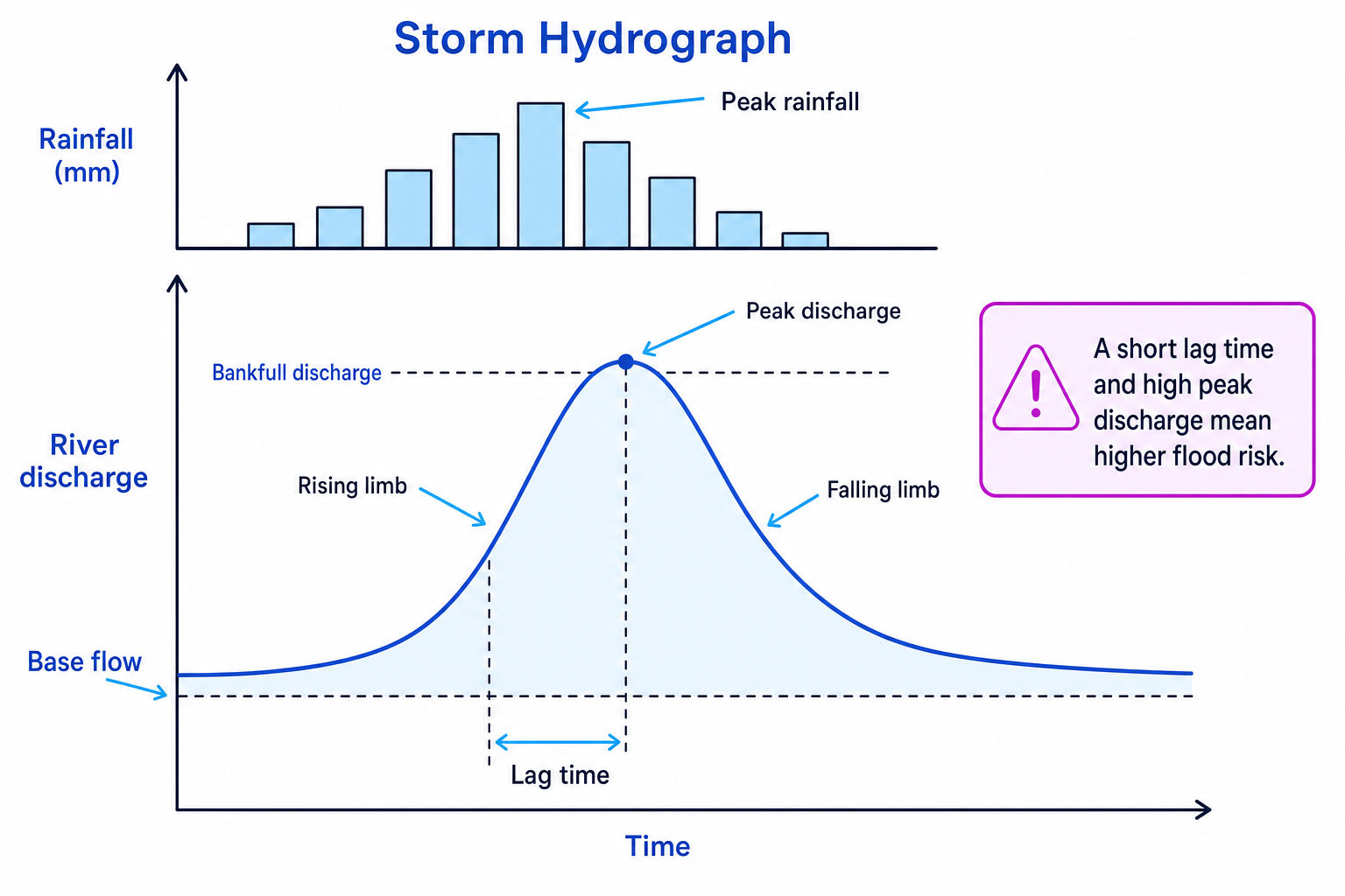
The rising limb shows discharge increasing. The falling limb shows discharge decreasing. Peak discharge is the highest discharge. Lag time is the delay between peak rainfall and peak discharge. Base flow is the normal flow of the river, often supplied by groundwater.
Discharge can be estimated using:
discharge=cross-sectional area×velocity\text{discharge} = \text{cross-sectional area} \times \text{velocity}discharge=cross-sectional area×velocityLag time is:
lag time=time of peak discharge−time of peak rainfall\text{lag time} = \text{time of peak discharge} - \text{time of peak rainfall}lag time=time of peak discharge−time of peak rainfallReading a hydrograph
- If peak rainfall is at 09:00 and peak discharge is at 13:00, the lag time is 4 hours.
- If peak discharge is 170 m³/s and bankfull discharge is 120 m³/s, the river is likely to flood because discharge exceeds the channel capacity.
- A steep rising limb and short lag time suggest a rapid response, often linked to intense rainfall, impermeable geology, steep relief or urban land use.
7. Managing flood risk
Hard engineering uses built structures to control the river. It can give strong protection, but it is often expensive and may increase flood risk elsewhere.
- Dams and reservoirs store water and can also supply drinking water or hydroelectric power, but they are costly and can damage habitats.
- Straightening makes a river flow faster through one area, but it can increase flood risk downstream.
- Embankments raise the river banks, but they need maintenance and can make flooding worse if they fail.
- Flood relief channels divert water around high-risk areas, but they require land and can be expensive.
Soft engineering works more with natural processes and planning.
- Flood warnings and preparation reduce risk to life and property, but they do not stop flooding.
- Flood plain zoning keeps important buildings away from high-risk areas, but it is difficult where towns already exist.
- Planting trees increases interception and infiltration, but it takes time and land.
- River restoration returns rivers to a more natural course, storing water on flood plains and improving habitats.
Hard does not always mean better
A hard-engineering scheme may protect one town but move flood water faster downstream. Strong exam answers consider social, economic and environmental impacts at different scales.
UK flood management example: Banbury, River Cherwell
Banbury in Oxfordshire flooded in 1998 and 2007. The flood management scheme, completed in 2012, used a flood storage area, embankments, flood walls, a pumping station and a raised road. Commonly used figures are about £18.5 million in cost, protecting around 441 homes and 73 businesses, though exact figures depend on your class source.
Evaluating the Banbury scheme
- Socially, the scheme reduces the chance of homes flooding, so residents face less stress, danger and disruption.
- Economically, the high cost can be justified because it protects homes, businesses, roads and local services from repeated flood damage.
- Environmentally, the flood storage area can create wetland habitats, but embankments and engineering works also change the landscape and may affect farmland.
- Overall, it is a strong scheme because it combines built defences with storage space, but it cannot remove flood risk completely.
In the exam
- For landform formation questions, write a clear sequence: process → action → landform feature.
- For hydrographs, quote evidence from the graph, such as lag time, peak discharge and whether bankfull discharge is exceeded.
- For management questions, balance benefits and costs using social, economic and environmental points, and name your UK example.
Check yourself
- How does a river’s long profile and cross profile change from source to mouth?
- Can you explain the formation of a waterfall or ox-bow lake using named processes?
- What does a short lag time and high peak discharge suggest about flood risk?