UK physical landscapes
What you'll learn
- How to locate the UK’s main upland areas — higher, hillier land — and lowland areas — lower, flatter land.
- The big national pattern: uplands are mainly in the north and west, while lowlands are mainly in the south and east.
- How major river systems — a main river and its smaller joining rivers — fit into that pattern.
- How to describe UK landscape patterns clearly using named places, compass directions and map evidence.
Where this fits in the course
This is the overview section for Physical landscapes in the UK. Everyone studies this national pattern first. Your class then studies two of the three landscape topics in more detail: coasts, rivers and glacial landscapes.
AQA will not expect a detailed case study for this overview section, but you do need to know the locations of major upland areas, lowland areas and river systems.
The UK as a physical landscape
The United Kingdom (UK) is made up of England, Scotland, Wales and Northern Ireland. Great Britain is the island containing England, Scotland and Wales, so it does not include Northern Ireland.
Physical landscape
A physical landscape is the natural shape and character of the land, including features such as mountains, valleys, plains, rivers and coasts.
When geographers describe landscapes, they often talk about relief.
Relief
Relief means the height and shape of the land. It includes how high the land is above sea level and how steep or flat it is.
So, in this topic, you are mainly asking: Where is the UK high and hilly, where is it low and flatter, and where do the main rivers flow?
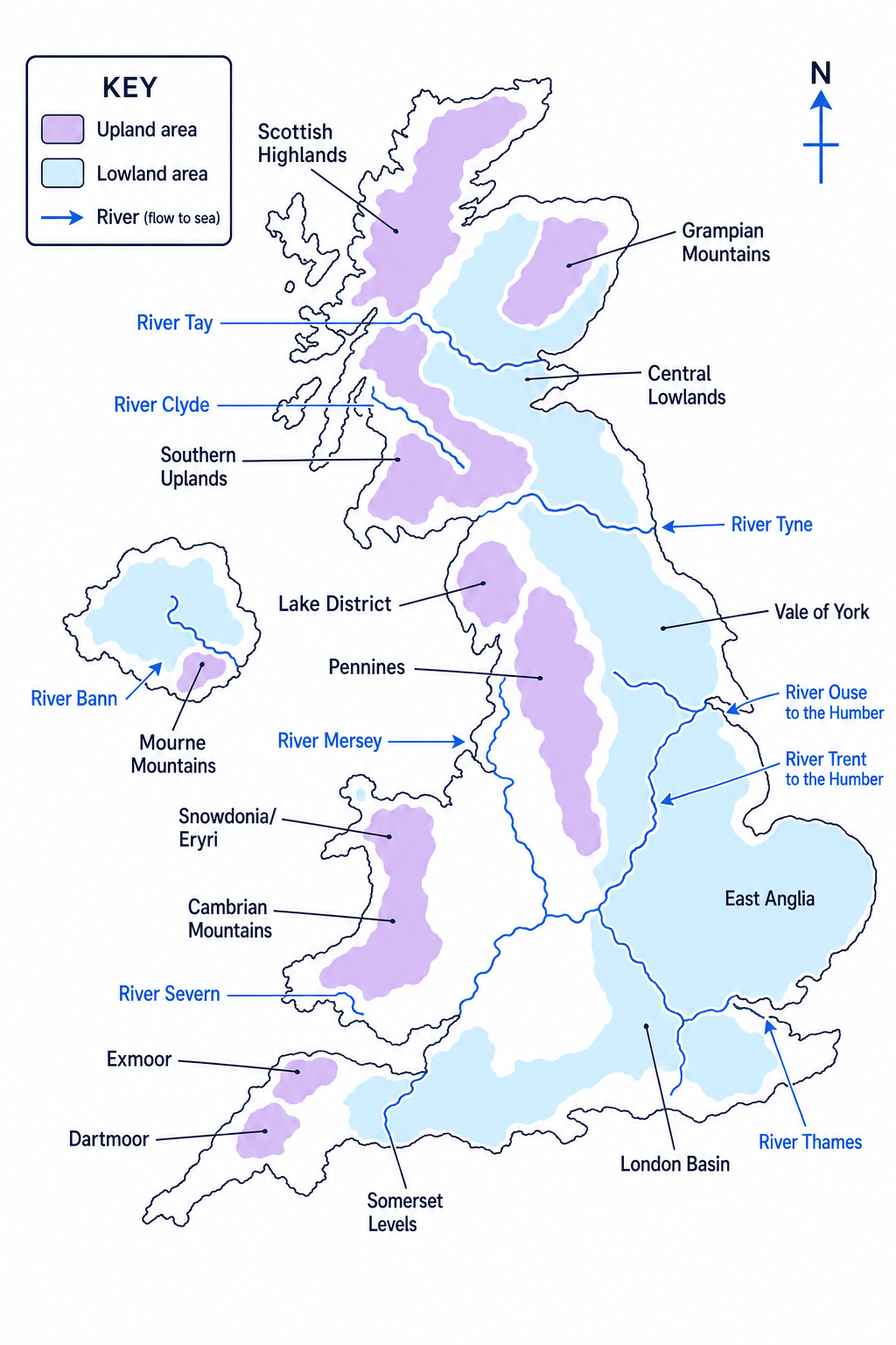
The map below is a simplified overview of the UK’s main upland areas, lowland areas and river systems. Use it to practise saying locations out loud with compass directions, such as “the Pennines are in northern England” or “East Anglia is in the east of England”.
Upland and lowland areas
Upland and lowland
Upland means higher, hillier land, often with steeper slopes and thinner soils. Lowland means lower, flatter or gently rolling land, often easier to farm, build on and travel across.
There is no single perfect height where “lowland” suddenly becomes “upland”, but on GCSE maps uplands are often shown as the higher, more rugged parts of the UK.
The big UK pattern
The UK’s uplands are mainly in the north and west, while the lowlands are mainly in the south and east.
Major upland areas
The main upland areas you should recognise are:
| UK area | Major uplands | Location clue |
|---|---|---|
| Scotland | Scottish Highlands, Grampian Mountains, Southern Uplands | Mostly northern, western and southern Scotland |
| Northern England | Lake District, Pennines | North-west England and a north-south “spine” through northern England |
| Wales | Snowdonia/Eryri, Cambrian Mountains, Brecon Beacons/Bannau Brycheiniog | Mainly north, central and south Wales |
| South-west England | Dartmoor and Exmoor | South-west peninsula |
| Northern Ireland | Mourne Mountains, Antrim uplands | Mostly north-east and south-east Northern Ireland |
The Pennines are especially important because they form a long upland “backbone” through northern England. Rivers often begin in or near upland areas like these.
Major lowland areas
The UK’s main lowland areas include:
| Lowland area | Where it is |
|---|---|
| Central Lowlands | Between the Scottish Highlands and Southern Uplands, including the Glasgow–Edinburgh belt |
| Vale of York | East of the Pennines in northern England |
| East Anglia | Eastern England, including Norfolk, Suffolk and Cambridgeshire |
| The Fens | Very flat, low-lying land around parts of Cambridgeshire, Lincolnshire and Norfolk |
| London Basin | South-east England around the River Thames and London |
| Somerset Levels | Low, flat land in south-west England |
Lowland areas are often where many people live, because flatter land is generally easier for farming, transport routes and settlements. For example, London developed on lowland around the Thames, while the Central Lowlands contain major Scottish cities such as Glasgow and Edinburgh.
Upland does not simply mean north
The north-west/south-east pattern is useful, but it is not perfect. Scotland has the Central Lowlands, and southern England has uplands such as Dartmoor and Exmoor.
Describing the pattern of uplands and lowlands
A question might ask you to describe the distribution of upland and lowland areas in the UK.
-
Compare the broad halves of the UK: the map shows a concentration of uplands in the north and west, especially Scotland, Wales and northern England, while many lowlands are in the south and east.
-
Add named evidence from more than one part of the UK: the Scottish Highlands, Pennines, Lake District, Snowdonia/Eryri and Cambrian Mountains support the upland pattern.
-
Add named lowland evidence: the Vale of York, East Anglia, London Basin and Fens show that much of eastern and south-eastern England is lowland.
-
Check the pattern against exceptions: Dartmoor and Exmoor are uplands in the south-west, while the Central Lowlands are in Scotland, so the pattern is strong but not absolute.
-
Combine this into a clear description: “UK uplands are mainly found in the north and west, including the Scottish Highlands, Pennines and uplands of Wales, while lowlands are more common in the south and east, including East Anglia, the Vale of York and the London Basin. However, there are exceptions such as Dartmoor in south-west England and the Central Lowlands in Scotland.”
River systems in the UK
A river is a natural channel of flowing water. Most rivers begin in higher land and flow downhill towards the sea, a lake or another river.
River system
A river system is the main river plus all its tributaries. A tributary is a smaller river or stream that joins a larger river.
A river’s source is where it begins. Its mouth is where it enters the sea, a lake or a larger body of water. The area of land drained by a river and its tributaries is called a drainage basin. The boundary between drainage basins is a watershed.
Why rivers link to uplands and lowlands
Many UK rivers begin in upland areas because these areas receive more rainfall and have steeper slopes. They then flow through lowlands towards the sea.
This means rivers help connect the UK’s physical landscape pattern: uplands often act as source areas, while lowlands often contain wider river valleys, estuaries and major settlements.
Estuary
An estuary is the tidal mouth of a river, where freshwater from the river meets saltwater from the sea.
Major UK river systems
You do not need to memorise every tributary, but you should recognise the major systems and roughly where they flow.
| River system | Basic location and flow |
|---|---|
| River Thames | Starts in the Cotswolds and flows east through southern England and London to the Thames Estuary |
| River Severn | Starts in the Cambrian Mountains in Wales and flows through the West Midlands to the Severn Estuary and Bristol Channel |
| River Trent | Drains much of the Midlands and flows north-east towards the Humber Estuary |
| River Ouse and Humber system | Drains parts of northern England, including the Vale of York, towards the Humber Estuary |
| River Mersey | Drains north-west England and flows west towards the Irish Sea near Liverpool |
| Rivers Tyne and Tees | Flow east from northern uplands towards the North Sea |
| River Clyde | Flows through the Central Lowlands of Scotland towards the Firth of Clyde |
| River Tay | Flows from the Scottish Highlands eastwards towards the North Sea |
| River Bann | A major river system in Northern Ireland, linked with Lough Neagh |
Source to mouth
For river locations, practise saying: source area → direction of flow → mouth. For example: “The River Severn starts in the Cambrian Mountains and flows generally south and west to the Severn Estuary.”
Assessing river flow direction
Suppose someone says: “Most major UK rivers flow south.” Use the UK landscape pattern to test this statement.
-
Apply the physical rule: rivers flow downhill from higher land to lower land or the sea, so their direction depends on where the uplands and nearest coasts are.
-
Test several named rivers: the Thames flows mainly east, the Severn flows south then west, the Trent flows north-east, the Tyne flows east, the Clyde flows west, and the Tay flows east.
-
Compare the evidence with the claim: because the named rivers flow in several directions, the statement “most flow south” is too simple.
-
Make a better judgement: many UK rivers begin in uplands in the north and west, but they flow towards the nearest lower land and sea, so their directions vary across the UK.
How to describe UK landscape location well
In this section, the skill is not just naming places. You need to describe their location accurately.
A weak answer might say: “Mountains are at the top and rivers go down.”
A stronger geography answer would say: “The UK’s main upland areas are concentrated in the north and west, including the Scottish Highlands, Lake District, Pennines and uplands of Wales. Major lowlands are more common in the south and east, such as East Anglia and the London Basin. Major rivers often rise in uplands and flow through lowlands to estuaries, such as the Severn and Thames.”
Do not use up and down on maps
On a map, say north, south, east and west instead of “up”, “down”, “left” and “right”. Maps are about direction, not the page.
Describe is not explain
If the question asks you to describe the location, focus on where places are found using compass directions and named examples. Do not spend the whole answer explaining rock type, climate or glaciation.
The core knowledge to remember
For this section, your “must know” list is fairly short:
- Uplands: mainly north and west.
- Lowlands: mainly south and east.
- Key uplands: Scottish Highlands, Grampian Mountains, Southern Uplands, Lake District, Pennines, Snowdonia/Eryri, Cambrian Mountains, Dartmoor, Exmoor, Mourne Mountains.
- Key lowlands: Central Lowlands, Vale of York, East Anglia, Fens, London Basin, Somerset Levels.
- Key rivers: Thames, Severn, Trent, Ouse/Humber, Mersey, Tyne, Tees, Clyde, Tay, Bann.
- Strong descriptions use pattern + named evidence + exception.
In the exam
-
When describing a map, give the overall pattern first, then support it with at least two named places.
-
Use accurate direction language: north-west, south-east, eastern England, western Scotland, not “top” or “bottom”.
-
For rivers, link the system to relief: mention whether it starts in uplands, the general direction it flows, and where it reaches the sea or an estuary.
Check yourself
- What is the broad pattern of upland and lowland areas across the UK?
- Can you name two upland areas and two lowland areas, and say where each one is?
- Choose one major UK river and describe its source area, direction of flow and mouth.