

What you'll learn
- How waves, weathering, mass movement, erosion, transportation and deposition shape UK coastlines.
- How rock type and geological structure help create landforms such as headlands, bays, stacks, spits and bars.
- How to use named UK examples for coastal landforms and coastal management.
- How to evaluate hard engineering, soft engineering and managed retreat. Coasts is one of the optional Physical landscapes topics, so learn it in detail if your class chose it.
1. The coast as a changing system
The coast is the zone where land, sea and air interact. It changes because energy from waves and gravity acts on rocks and sediment.
A physical process is a natural action that changes a landscape. At the coast, processes can break rock down, move sediment, build beaches, or cause cliffs to collapse.
Sediment
Sediment means loose material such as sand, shingle, pebbles, mud or broken rock fragments. Coastal sediment can be eroded from cliffs, brought by rivers, or moved along the shore by waves.
2. Waves: the main source of coastal energy
A wave is a movement of energy through water, usually caused by wind blowing over the sea surface. The longer the fetch — the distance wind blows over open water — the more energy waves can gain.
Important wave characteristics include:
- Crest: the highest point of a wave.
- Trough: the lowest point of a wave.
- Wave height: the vertical distance from trough to crest.
- Wavelength: the distance between two crests.
- Swash: water rushing up the beach after a wave breaks.
- Backwash: water flowing back down the beach under gravity.
Constructive and destructive waves
| Wave type | Main characteristics | Main effect |
|---|---|---|
| Constructive waves | Low, long waves; strong swash; weak backwash; often about 6 to 8 waves per minute | Build beaches by deposition |
| Destructive waves | Steep, high-energy waves; weak swash; strong backwash; often about 10 to 14 waves per minute | Erode beaches and cliffs |
Swash versus backwash
If swash is stronger than backwash, sediment tends to be pushed up the beach and deposited. If backwash is stronger than swash, sediment is dragged down the beach and erosion is more likely.
3. Processes that shape the coast
Weathering: breaking rock down in place
Weathering is the breakdown of rock where it is, without the material being carried away.
- Mechanical weathering breaks rock into smaller pieces without changing its chemical make-up. At the coast, freeze-thaw weathering can widen cracks when water freezes and expands.
- Chemical weathering changes the minerals in rock. For example, carbonation occurs when slightly acidic rainwater reacts with calcium carbonate in limestone or chalk.
Weathering is not erosion
Weathering breaks rock down in place. Erosion involves material being worn away and removed by the sea, rivers, wind or ice.
Mass movement: cliff material moving downhill
Mass movement is the downhill movement of rock or soil under gravity. It is common on coastal cliffs, especially after heavy rain.
- Rock falls happen when fragments break from a steep cliff and fall, often after cracks have been widened by weathering.
- Sliding happens when material moves downslope along a flat surface, such as a bedding plane.
- Slumping is a rotational movement along a curved slip plane. It is common in saturated clay cliffs and leaves a stepped or terraced cliff profile.
Erosion: wearing away the coast
Erosion is the wearing away and removal of rock or sediment.
The key coastal erosion processes are:
- Hydraulic power, also called hydraulic action: waves force water and air into cracks; pressure widens the cracks.
- Abrasion: rock fragments carried by waves scrape and grind against cliffs.
- Attrition: sediment particles collide with each other, becoming smaller, smoother and rounder.
Transportation and deposition
Transportation is the movement of sediment. The main process you need for coasts is longshore drift.
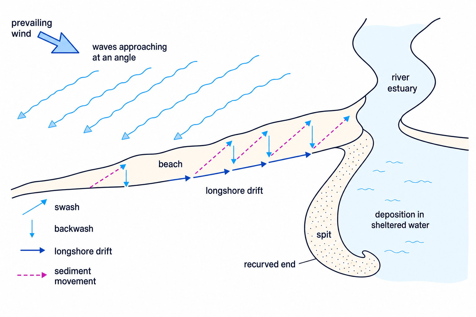
Longshore drift moves sediment along the beach in a zig-zag pattern. Waves usually approach the coast at an angle because of the prevailing wind. Swash carries sediment up the beach at that angle, while backwash pulls it straight back down under gravity.
Deposition happens when waves lose energy and can no longer carry their sediment. This often occurs in sheltered bays, behind spits, where water becomes shallower, or where the coastline changes direction.
The diagram shows how longshore drift can build a spit where sediment is deposited in sheltered water.
Predicting longshore drift
- Identify the wave approach: if the prevailing wind pushes waves towards the coast at an angle, swash will also move sediment up the beach at that angle.
- Apply gravity to the backwash: backwash flows straight down the beach slope, not back out at the same angle as the swash.
- Combine the two movements: each wave shifts sediment slightly along the coast, so deposition may build features such as spits where energy drops.
Calculating erosion rate
- Work out the time interval. If a cliff line retreated between 1980 and 2020, the time interval is 40 years.
- Divide distance retreated by time: erosion rate=72 m40 years=1.8 m/year\text{erosion rate} = \frac{72\ \text{m}}{40\ \text{years}} = 1.8\ \text{m/year}erosion rate=40 years72 m=1.8 m/year.
- Interpret the answer as an average. Future erosion may be faster or slower because storms, geology and management all affect cliff retreat.
4. Why coastlines look different
Rock type and geological structure
Rock type means what the rock is made from. Some rocks, such as granite or limestone, are more resistant than softer rocks such as clay or sand.
Geological structure means how rocks are arranged, including bedding planes, joints, faults and whether bands of rock run parallel or at right angles to the coast.
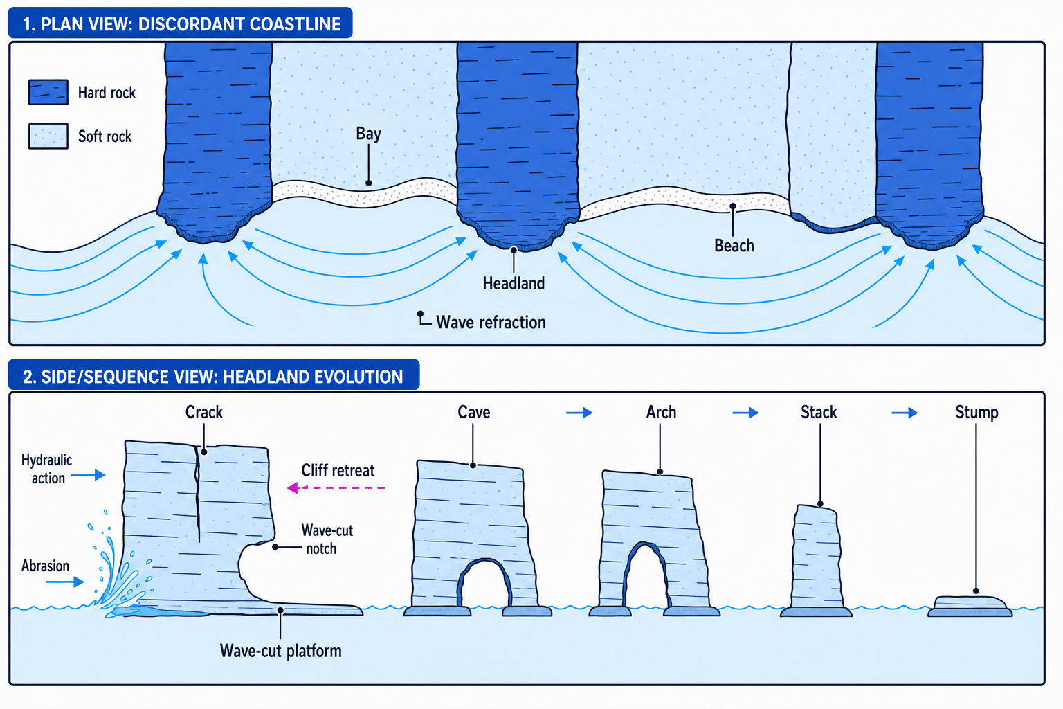
- A discordant coastline has alternating bands of hard and soft rock at right angles to the sea. Softer rock erodes faster to form bays, while harder rock remains as headlands.
- A concordant coastline has bands of rock parallel to the coast. A resistant outer band may protect softer rock behind it, but if it is breached, erosion can form a cove.
The diagram below brings together the main erosional landforms and shows how geology helps create headlands and bays.
5. Landforms created by erosion
Headlands and bays
A headland is a piece of land that sticks out into the sea. A bay is a curved inlet where the sea has eroded softer rock more quickly.
On a discordant coastline, soft rock erodes faster, creating bays. Hard rock erodes more slowly, forming headlands. Wave refraction bends waves around headlands, concentrating energy there and increasing erosion. Bays become more sheltered, so deposition often creates beaches.
Cliffs and wave-cut platforms
A cliff is a steep rock face along the coast. Destructive waves erode the cliff base, forming a wave-cut notch. Over time, the overhang becomes unsupported and collapses.
As this repeats, the cliff retreats inland and leaves a gently sloping rocky surface called a wave-cut platform, often visible at low tide.
Caves, arches, stacks and stumps
These usually form on headlands where there are cracks, joints or faults.
- Waves widen a crack using hydraulic power and abrasion.
- The crack becomes a cave.
- If erosion cuts through the headland, an arch forms.
- The arch roof collapses, leaving a stack.
- Further erosion reduces the stack to a stump.
Landform formation answers
For 4- or 6-mark formation questions, use a clear sequence: process → change to the rock → named landform. Include key terms such as hydraulic power, abrasion, collapse and deposition.
6. Landforms created by deposition
Beaches
A beach is an accumulation of sand or shingle between the high and low tide marks. Sandy beaches are often wide and gently sloping. Shingle beaches are usually steeper because larger particles are harder for backwash to move.
Sand dunes
Sand dunes are ridges or hills of sand found behind beaches. They form where there is a large supply of dry sand, an onshore wind, and obstacles such as driftwood or vegetation.
Plants such as marram grass trap sand. Their roots help bind the dune together, making the dune more stable over time.
Spits
A spit is a long, narrow ridge of sand or shingle attached to the land at one end. It forms when longshore drift moves sediment along the coast and the coastline suddenly changes direction, such as at a river estuary. Wave energy drops, so sediment is deposited. The end may curve due to changing wind or wave direction.
Bars
A bar is a ridge of sand or shingle that extends across a bay or estuary. If it traps water behind it, a lagoon may form. A related feature, a tombolo, links the mainland to an island.
Identifying landforms on the Dorset coast
- Link landforms to geology: on parts of the Dorset coast, resistant limestone and chalk form headlands, while softer clays and sands erode more quickly to form bays.
- Match erosional landforms to named places: Old Harry Rocks are chalk stacks, Durdle Door is a limestone arch, and Swanage Bay shows softer rock eroded between harder headlands.
- Match depositional landforms to named places: Chesil Beach is a major shingle beach and barrier feature, with The Fleet lagoon behind it, while Studland has sand dunes.
7. Managing the coast
Coastal management means using strategies to reduce risks from erosion and coastal flooding. The best strategy depends on land value, erosion rate, population, habitats, cost and long-term sustainability.
There are three main approaches:
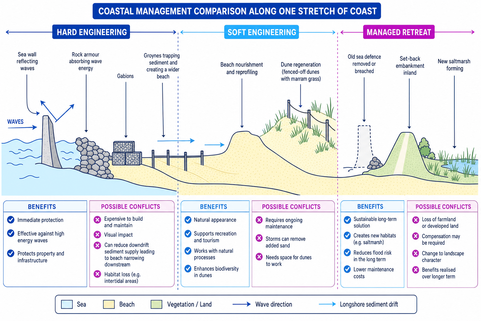
- Hard engineering: building artificial structures to control the sea.
- Soft engineering: working with natural processes, often by adding or managing sediment.
- Managed retreat, also called coastal realignment: allowing the sea to flood selected low-value land in a controlled way, with defences moved inland.
This diagram compares common coastal management methods and the conflicts they can create.
| Strategy | How it works | Benefits | Costs and conflicts |
|---|---|---|---|
| Sea wall | Concrete wall reflects or absorbs wave energy | Strong protection; can create a promenade | Very expensive; reflected waves may scour the beach |
| Rock armour | Large boulders absorb wave energy | Cheaper than sea walls; quick to build | Can look unnatural; boulders may be costly to transport |
| Gabions | Wire cages filled with rocks absorb energy | Relatively cheap and flexible | Wire can rust or break; often visually unattractive |
| Groynes | Wooden or rock barriers trap sediment moved by longshore drift | Wider beach absorbs wave energy; helps tourism | Can starve beaches down-drift, increasing erosion elsewhere |
| Beach nourishment and reprofiling | Sand or shingle is added or reshaped | Natural appearance; improves beach amenity | Needs repeated maintenance after storms |
| Dune regeneration | Marram grass, fencing and boardwalks protect dunes | Creates a natural buffer and habitat | Fragile; needs space and access control |
| Managed retreat | Defences are moved inland and some land is allowed to flood | Can create saltmarsh habitats; lower long-term maintenance | Loss of farmland or property can cause conflict |
Explaining management at Mappleton
- Give the reason for management: Mappleton is on the Holderness Coast in East Yorkshire, where soft boulder clay cliffs are eroded by North Sea waves. Homes and the B1242 road were at risk.
- Name the strategy: in 1991, rock armour and two rock groynes were built to protect the village and trap sediment, creating a wider beach.
- Explain the local effects: erosion at Mappleton was reduced, and the village and road gained stronger protection.
- Explain the conflict: the groynes reduced sediment moving south by longshore drift, so beaches down-drift received less material and erosion increased near Great Cowden.
In the exam
- For landform formation, write in a sequence and name the processes: for example, “hydraulic power widens cracks, abrasion enlarges the cave, collapse leaves a stack.”
- For management questions, balance benefits and costs rather than saying a strategy is simply “good” or “bad”.
- Use place detail in examples: name the coastline, describe the geology or risk, identify the strategy, and explain effects or conflicts.
Check yourself
- Can you explain the difference between constructive and destructive waves using swash and backwash?
- Can you describe how a crack in a headland can eventually become a stack?
- Can you give one UK example of coastal management and explain both a benefit and a conflict?
