What you'll learn
- What makes a hot desert ecosystem distinctive.
- How climate, water, soils, plants, animals and people depend on each other.
- A case study of development opportunities and challenges in a hot desert.
- Why desertification happens on desert fringes, and how it can be managed.
Hot deserts is the optional Living World environment if your class is not studying cold environments. You still need the ecosystems overview and tropical rainforests as well.
1. What is a hot desert?
Hot desert
A hot desert is an arid ecosystem, meaning it receives very little rainfall, usually less than 250 mm per year, and has high temperatures for at least part of the year.
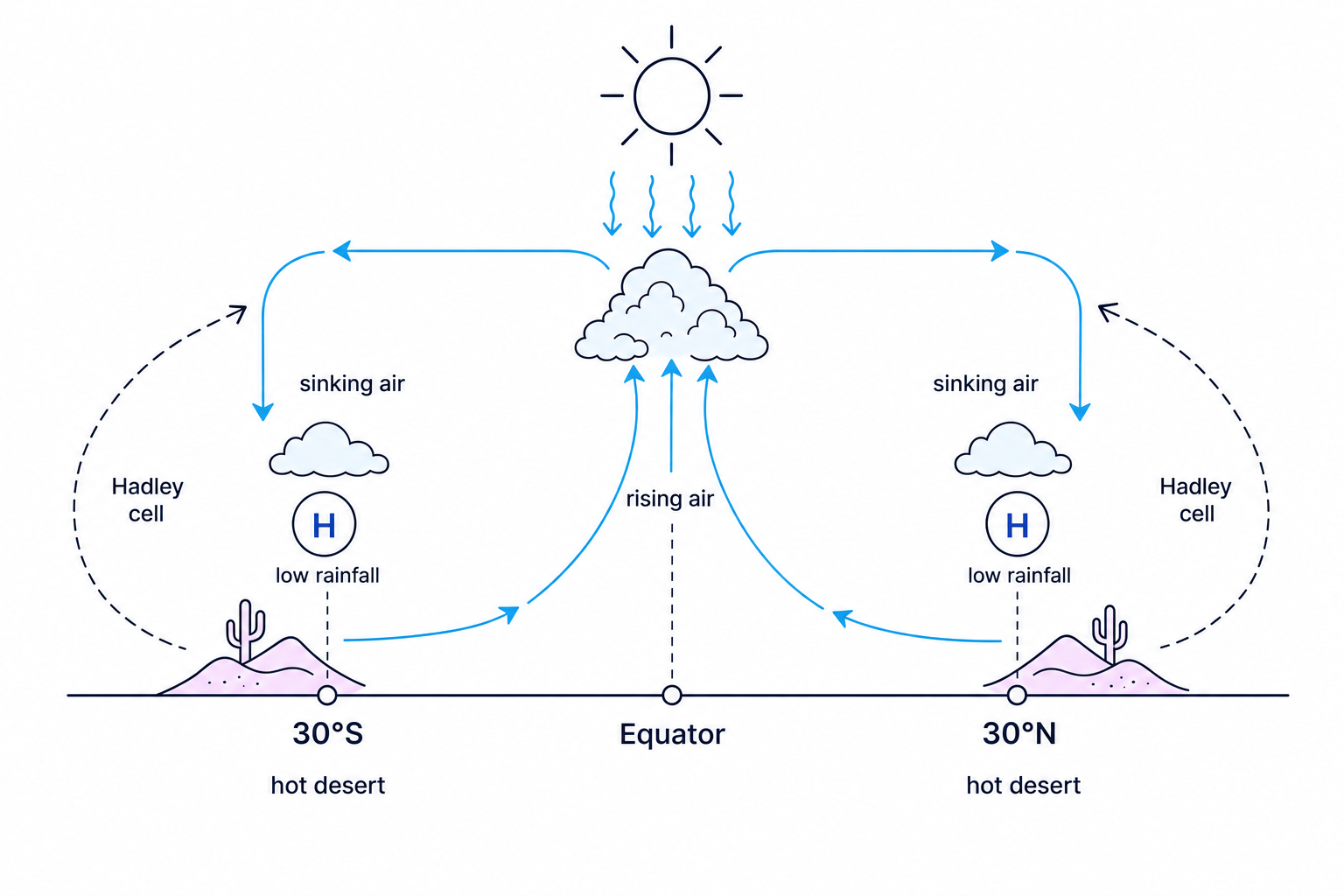
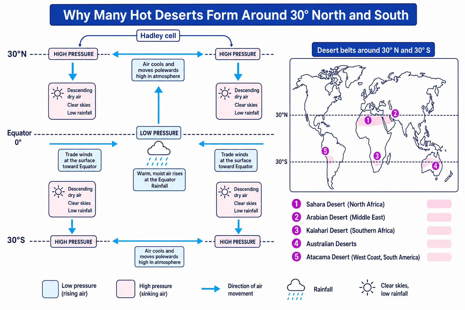
Most hot deserts are found between about 15° and 35° north and south of the Equator, especially around 30°N and 30°S. This is linked to global atmospheric circulation, the large-scale movement of air around the planet. A Hadley cell is a loop of air where warm air rises near the Equator, moves polewards, then sinks around 30° latitude. Sinking air creates high pressure, clear skies and low rainfall.
Physical characteristics
Hot deserts are not all identical, but they commonly have:
- Very low rainfall: rain is unreliable and may fall in short, intense storms.
- High daytime temperatures: often above 40°C in summer.
- Large diurnal temperature range: the difference between day and night temperatures can be large because clear skies allow heat to escape at night.
- High evaporation: water changes from liquid to vapour quickly in the heat.
- Sparse vegetation: plants are widely spaced because water is limited.
- Dry soils: often sandy or stony, with little organic matter from dead plants and animals.
- Temporary rivers: a wadi is a dry river channel that only carries water after rainfall.
- Oases: places where groundwater reaches the surface, allowing settlement or farming.
Classifying a hot desert climate
A place has annual rainfall of 160 mm. In July, the daytime temperature reaches 40°C and the night temperature falls to 18°C.
- Compare the rainfall with the desert threshold: 160 mm is below 250 mm, so the place is arid.
- Check the heat: 40°C daytime temperatures show the environment is hot, not just dry.
- Calculate the day-night temperature range: 40−18=2240 - 18 = 2240−18=22, so the range is 22°C.
- Use all three pieces of evidence together: low rainfall, high daytime heat and a large daily temperature range strongly suggest a hot desert climate.
2. How the desert ecosystem works
An ecosystem is a community of living things interacting with each other and with the non-living environment. The living parts are biotic factors, such as plants and animals. The non-living parts are abiotic factors, such as climate, water and soil.
Interdependence
Interdependence means that the parts of an ecosystem rely on each other, so a change in one part affects others.
In a hot desert, water is the key limiting factor. Low rainfall means few plants can grow. Fewer plants means less food and shelter for animals. Thin vegetation also means soils are less protected from wind and sudden rainstorms.
People are part of this system too. Settlements often grow near oases, rivers, canals or boreholes. Farming, tourism, mining and road building can bring income, but they can also increase pressure on water supplies and fragile soils.
Water links the ecosystem
In hot deserts, climate controls water availability; water controls soils and vegetation; vegetation supports animals and people. This is the main chain to remember.
3. Plant and animal adaptations
An adaptation is a feature or behaviour that helps a living thing survive in its environment. A xerophyte is a plant adapted to dry conditions.
| Organism | Adaptation | How it helps |
|---|---|---|
| Cactus or succulent plant | Stores water in thick stems | Survives long dry periods |
| Cactus | Spines instead of broad leaves | Reduces water loss through transpiration, which is water loss from plant leaves |
| Desert shrub | Waxy leaves | Reduces evaporation from the leaf surface |
| Acacia tree | Deep roots | Reaches groundwater far below the surface |
| Ephemeral plant | Rapid life cycle after rain | Flowers and sets seed before the soil dries |
| Camel | Fat stored in hump | Provides energy when food is scarce |
| Fennec fox | Large ears | Releases heat from the body |
| Many reptiles and rodents | Nocturnal behaviour | Avoids the hottest part of the day |
| Kangaroo rat | Very concentrated urine | Loses less water from the body |
Deserts are not lifeless
Hot deserts often have low biomass, meaning a low total mass of living material, but they can still contain specialised and important species.
4. Biodiversity issues
Biodiversity means the variety of living things in an area. Hot desert biodiversity is often fragile because plants grow slowly and recovery after damage can take a long time.
Key threats include:
- Water abstraction: taking groundwater faster than it is replaced.
- Overgrazing: too many animals eating vegetation, exposing soil.
- Mineral extraction: mines, roads and pipelines can break up habitats.
- Tourism pressure: off-road vehicles can damage plants and soil crusts.
- Climate change: higher temperatures and longer droughts may make survival harder.
5. Case study: Thar Desert, India and Pakistan
A case study is a detailed place example. A common GCSE case study is the Thar Desert, which covers parts of Rajasthan in north-west India and south-east Pakistan. Exact figures vary by source, but it is around 200,000 km² and is one of the most densely populated desert areas in the world.
Development opportunities
- Mineral extraction: gypsum, limestone, feldspar and phosphorite are quarried or mined. These create jobs and provide raw materials for industries such as cement.
- Energy: the Thar has high sunshine levels, making it suitable for solar power. Rajasthan contains very large solar developments, including Bhadla Solar Park.
- Farming: irrigation from schemes such as the Indira Gandhi Canal allows crops such as wheat, mustard and cotton in some areas. Goats, sheep and camels are also kept.
- Tourism: Jaisalmer, desert festivals, camel safaris and historic forts bring income to local people.
Development challenges
- Extreme temperatures: very high heat makes construction, farming and outdoor work difficult and can cause heat stress.
- Water supply: rainfall is low and unreliable; groundwater may be salty or overused.
- Inaccessibility: dunes, long distances and sparse transport links make it expensive to move people, goods and services.
Balancing solar energy development in the Thar Desert
- Identify the opportunity: high sunshine and large open spaces make solar power efficient and can create jobs.
- Weigh the challenge: panels need cleaning, workers need water, and remote sites need expensive grid connections.
- Make a judgement: solar energy is a strong opportunity, but it is most sustainable where water use is managed and links to the electricity grid already exist or can be built.
6. Desertification on desert fringes
Desertification
Desertification is the degradation of land in dry areas, making it less productive and more desert-like. It often affects semi-arid areas, which are dry but not true deserts.
A key located example is the Sahel, a semi-arid belt south of the Sahara across countries such as Senegal, Mali, Niger, Chad and Sudan.
Causes of desertification
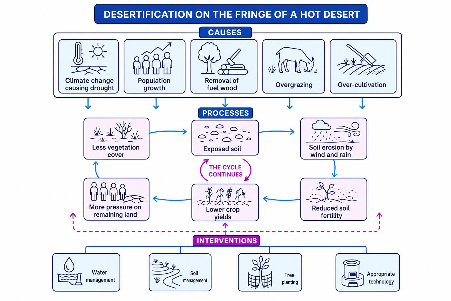
- Climate change: higher temperatures increase evaporation, and rainfall may become less reliable.
- Population growth: more people need food, fuel and farmland.
- Removal of fuel wood: cutting trees for cooking fuel removes roots that bind soil.
- Overgrazing: animals eat vegetation faster than it can regrow.
- Over-cultivation: farming land too intensively reduces soil nutrients.
- Soil erosion: once vegetation is removed, wind and rain can strip away fertile topsoil.
Linking overgrazing to desertification
- More livestock graze the same area, so grasses and shrubs are eaten before they recover.
- With less vegetation, roots no longer bind the soil and leaves no longer protect it from rain or wind.
- Exposed topsoil is eroded, reducing soil fertility and making crop growth harder.
- Lower yields increase pressure to use more land, continuing the cycle of desertification.
7. Reducing the risk of desertification
Strategies work best when they are low-cost, local and maintainable.
- Water management: rainwater harvesting, small dams, drip irrigation and zai pits help store water and direct it to crops.
- Soil management: stone lines, contour bunds, terracing and mulching slow runoff, trap sediment and protect soil moisture.
- Tree planting: shelter belts and projects such as the Great Green Wall in the Sahel reduce wind erosion and add organic matter through leaf litter.
- Appropriate technology: simple, affordable tools such as fuel-efficient stoves, solar cookers and hand pumps reduce pressure on wood and water.
Boreholes are not always a simple fix
Boreholes can improve water access, but if too many animals gather around them, overgrazing near the water point can make land degradation worse.
Build chains, not lists
For desertification questions, link cause to process to impact: less vegetation → exposed soil → erosion → lower fertility → lower yields.
In the exam
- For hot desert characteristics, use precise evidence: low rainfall, high evaporation, sparse vegetation and thin soils.
- For the case study, name the desert and organise your answer into opportunities and challenges.
- For desertification, write in linked chains and include at least one named management strategy.
Check yourself
- Why do many hot deserts form around 30° north and south of the Equator?
- How does one plant and one animal adaptation help survival in hot deserts?
- How can overgrazing lead to desertification?